
Crime Patterns Made Clear for Portland, Oregon, Citizens via Internet Mapping
 A key approach the City of Portland, Oregon, uses to reduce crime is "community policing." Community policing is about citizens and police working together to understand when and, more importantly, where crime occurs to develop effective prevention and problem solving strategies. In February 2001, the City launched a neighborhood crime mapping application for the general public called CrimeMapper (www.portlandpolicebureau.com) to help do this. In addition to mapping, this application also creates detailed graphs and "spatial reports" to allow even the most novice user to access detailed crime pattern information.
Above right: Users can view overall crime report including percentage breakdown of specific types of crime.
The primary goal of the Portland Police Bureau is to reduce crime and the fear of crime. The new Web mapping application supports this goal by
- Providing information about reported crime to the public so people have a more comprehensive view of what is occurring in their neighborhood.
- Encouraging involvement in problem solving efforts through links to service providers.
- Providing a tool for public safety partners to evaluate their efforts to see if their activities are having an effect on reported crime in their neighborhood or Business district.
- Demonstrating partnership with the Office of Neighborhood Involvement (ONI), Neighborhood Watch block captains, and other municipalities and jurisdictions.
"Our goal of a '24-hour City Hall' is seeing success with this project. All community members with access to the Internet can now have this information 24 hours a day," said Portland Mayor Vera Katz. "This also shows that police are out front in sharing this information and being held accountable for it."
Portland Police Chief Mark Kroeker said the tool will be a vital communication link between Neighborhood Watch block captains, neighborhood crime prevention specialists, and senior neighborhood officers. "Timely information, combined with good analysis and partnership, will help people to make a difference in our neighborhoods," said Kroeker.
 When a citizen or police officer enters the City's site, they can either enter a street address or intersection or go directly to an interactive map. Once they have selected a location, the application automatically creates a map, report, and graphs that provide a comprehensive analysis of crimes in the vicinity of that location. Users can then view graphs showing total reported incidents for each crime type within a quarter mile grid or incidents by time (e.g., month, day, or time of day). Throughout, the Police Bureau is committed to retaining the confidentiality of sensitive information.
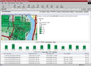
Above right: Users can also view incidence of a specific type of crime within one half mile of a selected address.
The Police Bureau obtained funding for this project in 1999 under a Bureau of Justice Assistance (BJA) Block Grant. Shortly thereafter, the Police Bureau formed a partnership with the City's Bureau of Information Technology, Corporate Geographic Information Systems (CGIS) Division, to design, develop, and host the new system.
CGIS built the crime mapping application in a few months using Esri's MapObjects Internet Map Server (IMS), Allaire's ColdFusion, and GeoNorth's MapOptix. CGIS selected these technologies because they were proven, leveraged the City's previous technology investment, and could be implemented rapidly and customized cost-effectively. It was also important for the application to perform well at typical household Internet connection speeds.
"I'm very pleased with the way this application leverages the City's technology investment and enhances the safety of our citizens," said Rick Schulte, CGIS manager.
A critical technical challenge CGIS faced in the development of this system was getting incident data from the Police Department's IBM OS 390 mainframe to the Internet mapping application for publication. This needed to be done monthly to provide timely information to citizens and the Police Department. Mike Quetel, CGIS solutions architect, developed a Visual Basic/MapObjects 2 program to make this process as quick and painless as possible.
The City regards its GIS as mission critical and has put in place a robust architecture for serving the crime mapping application and numerous other GIS applications to the general public and more than 5,000 City employees. CGIS hosts these applications on a multitiered system. Two four-way IntelPentiumIII 500 MHz Xeon servers deliver Web and ColdFusion content. Four dual IntelPentiumIII 1 GHz processor map servers running and MapOptix keep the maps flowing. Clustered file servers attached to fiber channel storage deliver shapefiles. A cluster of two eight-way IntelPentiumIII 550 MHz Xeon database servers performs all the dynamic data requirements. All servers run on a Windows 2000 server. The crime application has had 99.99 percent uptime with traffic peaking at more than 1,000 hits per minute.
For more information, contact Rick Schulte, CGIS manager, City of Portland (tel.: 503-823-5634, e-mail: ricks@ci.portland.or.us), or Andy Sloop, GeoNorth (tel.: 877-827-0827, e-mail: asloop@geonorth.com).