
I-Team Initiative Addresses Institutional and Financial Barriers to NSDI
 By Ronald Matzner, Senior Vice President, Trebizon International Enterprises, and Bruce Cahan, President, Urban Logic
The I-Team Geospatial Information Initiative (I-Team Initiative) inaugurates a new phase in efforts led by the Federal Geographic Data Committee (FGDC) to steward development of the National Spatial Data Infrastructure (NSDI). For nearly a decade, the FGDC focused on the common principles, technical and data standards, and clearinghouse networks needed to enable governments, Businesses, and the public to use spatial data most effectively. Although effective, the FGDC did not have available to it a mechanism to offer the financial and institutional incentives necessary to induce federal, state, and local authorities to collaborate fully. The I-Team process provides those incentives.
The I-Team Initiative is a collaboration among the FGDC; Federal Office of Management and Budget; the Council for Excellence in Government; Urban Logic; TIE; the National Association of Counties; other Federal, state, local, and tribal authorities; and the private sector. It addresses the institutional and financial barriers to development of the NSDI. The I-Team Initiative aims to offer a coherent set of institutional and financial incentives to make it easier for all levels of government and the private sector to collaborate in the building of the next generation of framework data.
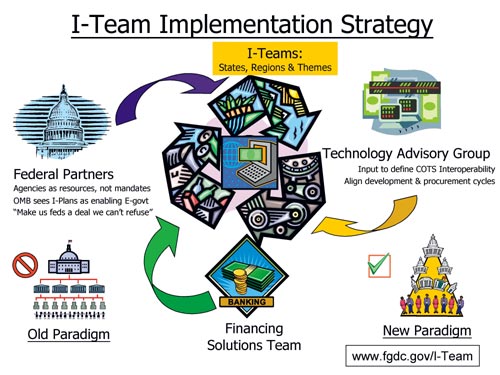
I-Teams
I-Teams are locally formed, interdependent partnerships of federal, state, local, and tribal authorities; academia; and the private sector. I-Teams implement state and regional portions of the NSDI in their own best interests as part of their ordinary Business processes, shaping and helping to define the very data standards and interoperability specifications that they need to use. What is unique about I-Teams is that they bring all relevant and affected providers and users of data together around the same table, shifting the balance of power for decision making downward from the federal to the state and local level. I-Teams are voluntary, open, flexible, and adaptive collaborations for sharing capital planning, building, use, and financing of spatial data. They align and optimize interdependencies, helping to develop standards and implement specifications by consensus among I-Teams.
Seventeen states and regions already have begun the I-Team process. The latest states to join the effort are California, Indiana, and Kansas. They join Delaware, Arkansas, Nebraska, Utah, New Jersey, Metro New York, Arizona, Maryland, Montana, Colorado, Texas, Virginia, and North Carolina. Other states are poised to do so.
Each I-Team develops a strategic I-Plan. Utah's I-Plan, the first to be completed, has become a model for other states. Montana and Maryland completed their I-Plans in July 2001.
In addition to I-Teams created to build out a state or region's framework and other layers, several counties and regions have begun application-oriented I-Teams focusing on one or more specific framework layers. Miami-Dade, Broward, and Palm Beach counties in Florida have created an Environmental Monitoring I-Team. Washington, Oregon, and Idaho are cooperating to form an I-Team focusing first on the transportation layer, and eight mid-Atlantic states are collaborating under the leadership of the EPA on a Land Use/Land Cover I-Plan.
Leveraging Investment
A Financing Solutions Team (FST) will develop the Business case for aligning investments to make the most of existing resources, ensure that adequate resources are available in the future, and explore opportunities for alternative mechanisms for financing spatial data investments. The FST held its first meeting on October 2 at the American Institute of Architecture in Washington, D.C. Scores of experts in government procurement and appropriations, as well as underwriting and other private sector funding mechanisms, were invited to participate.
Federal Partners
A Federal Partners Team composed of senior federal officials directs federal participation in the I-Team process. Federal Partners will make sure their agencies work together to align investments and explore interagency and intergovernmental partnerships. In conjunction with the FST session on October 2, the Council for Excellence in Government hosted a luncheon at which it introduced the I-Team Federal Partners. As of press time, Federal Partners are Dr. Charles Groat, director, USGS; Margaret Davidson, associate administrator, NOS, NOAA; Ghassam R. Asrar, associate administrator, Earth Science Enterprise, NASA; Mack Gray, acting associate undersecretary, USDA; Dr. Ashish Sen, director, Bureau of Transportation Statistics, DOT; Pete Culp, assistant director, Minerals, Realty, and Resource Protection, BLM; Margaret Schneider, acting assistant administrator, Office of Environmental Information, EPA; Bob Marx, chief, Geography Division, U.S. Census Bureau; Charles Challstrom, director, NGS; and Michael Buckley, director, Technical Services Division, Mitigation Directorate, FEMA.
Technology Advisory Group
The Open GIS Consortium has offered its assistance to form a Technology Advisory Group (TAG) and to provide a level of support to sustain TAG activities. The TAG will be a special interest group (SIG) of the Open GIS Consortium, convening as part of the OGC Technical Committee every two months. All I-Teams will be afforded OGC associate membership free of charge for one year provided that I-Team Business plans include clear criteria and incentives for the procurement of commercial off-the-shelf products that adhere to commercial and international interoperability standards. The Open GIS Consortium approach provides a venue for I-Teams to interact with industry to address technology trends, specific technology issues, and recommendations on the most appropriate use of standards-based spatial technologies in meeting I-Team Business plan objectives.
Web Site--A Virtual Community Center
The initiative will launch its Web site soon, styled as a virtual community center. The Web site is under development at www.fgdc.gov/I-Team. Each I-Team will have its own portion of the site at which I-Team participants can interact and collaborate with other I-Teams. The site will enable I-Team members to hold meetings on the Web and to work collaboratively on documents (such as I-Plans). Among other features, the site will have a master calendar of I-Team activities and a listing of funding and resource opportunities. The I-Team resource teams (Federal Partners, TAG, and FST) will have space on the site, enabling all members of the initiative to interact and leverage the knowledge and experience available within and outside their teams.
A Bridge to Policy Makers
I-Teams are ideally positioned to leverage federal and private sector participation. The I-Team Initiative optimizes the benefit, reduces collection burden, and improves the quality of spatial data in a way that carries out long-standing Office of Management and Budget (OMB) and congressional information technology objectives. I-Plans can be benchmarks for OMB to use to identify partnering opportunities and avoid duplication when considering agency budget and information collection requests. The I-Team Initiative engages OMB oversight more directly than previous NSDI efforts and provides a federal champion where it will do the most good at the nexus among OMB and the federal agencies.
For more information, visit the I-Team web site at www.fgdc.gov/I-Team or contact Ronald Matzner (e-mail: rmatzner@fgdc.gov) or Bruce Cahan (e-mail: bcahan@urbanlogic.org). Matzner is senior vice president of Trebizon International Enterprises, Alexandria, Virginia. He is coordinator of the I-Team Initiative. Cahan is president of Urban Logic, a nonprofit organization located in New York City. He is director of the Financing Solutions Team.
See sidebar, I-Team Contact Information