
Lighthouse Helps USDA-NRCS Clients
With an eye toward rapid and efficient access to natural resource data for its customers, the U.S. Department  of Agriculture (USDA) Natural Resources Conservation Service (NRCS) launched the Lighthouse Project in 2000.
Right: The Lighthouse Project brings together two ongoing projects--the Resource Data Gateway and Web Soil Data Viewer.
Since the 1930s, the NRCS has been mapping soils and delivering soil information to the public and providing technical assistance to other government agencies and agricultural and conservation groups. While the NRCS had accumulated a stockpile of information, it was not readily accessible. In 1995, following recommendations from a panel of specialists, the NRCS began developing a plan to release the data that was trapped on paper.
During an evaluation of its information technology architecture, the NRCS realized the importance of creating a Web-enabled, centralized repository of geospatial and tabular soil data. "USDA's goal is to provide one-stop shopping for natural resource data 'to anyone, at anytime, from anywhere,'" said Wendall Oaks, project manager at the USDA-NRCS Information Technology Center in Fort Collins, Colorado.
Into the Twenty-First Century
The goals of the project were to use commercial off-the-shelf technology to shorten system development life cycles, move to a distributed networked N-tier enterprise architecture, and convert user and database interfaces to user-friendly graphical user interfaces.
The effort brings together two ongoing projects that manage and deliver broad-scale, enterprise data from USDA and other federal data providers. The projects--Resource Data Gateway and Web Soil Data Viewer--when complete will support the data needs of 13,000 federal employees in 3,000 field offices, and farmers, ranchers, and other USDA customers.
NRCS began work collaboratively with Compaq and Microsoft to design and implement an integrated system that would offer easy online access to geospatial data. Esri is the geospatial technology provider for the Lighthouse Project, which implements Esri's ArcView GIS, ArcIMS, and ArcSDE.
Easy-to-Use Web Application
The Web Soil Data Viewer is an Internet application that takes advantage of soil surveys that have been digitized. With this tool, USDA employees can produce maps that 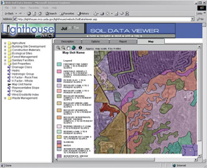 display soils information and combine soils themes with other geographic information. The Web Soil Data Viewer helps answer questions such as how the soils located in a specific site should be used to conserve resources and promote water quality.
Left: The Web Soil Data Viewer helps answer questions such as how the soils located in a specific site should be used to conserve resources and promote water quality.
The application uses ArcIMS and ArcSDE with a SQL Server 7 database. Using server-to-server communications, digital orthoquadrangle images are retrieved from Microsoft's TerraServer and merged with other map information. "Esri's strength in building cross-cutting technologies and working with solutions partners has paid off in this effort where ArcIMS is the mechanism whereby the merging of these various data sets takes place and is rendered into JPEG files for delivery to the end user through their Web browser," said John Steffenson, USDA account manager for Esri.
The Web Soil Data Viewer relies on four databases to provide real-time creation of user selected interpretive soil maps and reports. Custom-developed application software integrates the soil geospatial data with relational soil data contained in two separate SQL Server databases. The Microsoft TerraServer provides the digital orthophotography, and the Lighthouse ArcIMS server creates the soils map using the digital orthoimage as a backdrop.
Resource Data Gateway
The Resource Data Gateway offers a single access point to geospatial data and automates many of the manual processes associated with natural resource data delivery. 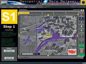 Users can browse, select, and order data from a particular location in a specified projection and format and have it automatically delivered.
Three GIS themes are currently available to users via the Resource Data Gateway--soils, orthophotography, and demographics. The USDA has identified more than 20 geospatial themes such as plants, climate, hydrography, roads and streams, and wetlands, which it plans to provide in the database.
Commercial Off-the-Shelf Software
"The USDA's Lighthouse Project represents a significant breakthrough in the use of commercial off-the-shelf software to integrate existing applications and data over the
Web," said Tom Barclay, program manager in Microsoft's Bay Area Research Center. "The USDA team has demonstrated how XML Web Services, built on W3C Web technologies and XML,
 can be integrated with high-performance servers such as Microsoft SQL Server to deploy very powerful systems rapidly and affordably."
Right: The Resource Data Gateway offers a single access point to geospatial data and automates many of the manual processes associated with natural resource data delivery.
Compaq provided the project with server and storage hardware and coordinated the overall system architecture, a solutions methodology that enabled the integration of all its components. "The Lighthouse Project is a great example of how complex, integrated solutions can be implemented using products from market leaders and following a structured methodology," said Robert Macfarlane, Compaq engagement manager.
Receiving Recognition
The Lighthouse Project won an award in the Data Warehousing Institute (TDWI) 2001 Best Practices in Data Warehousing Competition. TDWI of Seattle provides education and training to the data warehousing and Business intelligence industry. The competition brings examples of innovative best practices to thousands of information technology professionals.
DWI announced the winners May 21 and named 15 Best Practices winners in two categories--applications and industry. The USDA-NRCS was an industry winner. The award cited the department's efficiency in providing quality products and services.
The Soil Data Viewer also placed second in the Geography Network Challenge this year. The Geography Network Challenge, sponsored by Esri and the National Geographic Society, is a competition intended to increase the awareness and highlight the numerous capabilities of Internet-based mapping services and applications.
Access the Web Soil Data Viewer at lighthouse.nrcs.usda.gov/lighthouse. For more information, contact Steve Ekblad, the development team leader for the USDA Service Center Initiative (e-mail: sekblad@itc.nrcs.usda.gov).