
GIS-Formatted Weather Data Is Now Available to Broader Audience
Today's Forecast Mostly Sunny for GIS Users
Please note that since this article was first printed in ArcNews, Meteorlogix Weather Services LLC changed its name to Meteorlogix LLC. This page has been updated to reflect the new name.
Making plans for the weekend? More than likely, you'll check the weather forecast to see if you should pack your umbrella or sunglasses. Because meteorology reaches more people on a daily basis than any other science, weather images generated by satellite or radar are familiar to almost everyone. Now it's possible for those images to bring you more than just the weekend forecast.
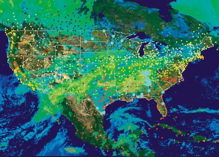
Maximumn temperature measurements can be analyzed using geostatistics
(or Esri's Geostatistical Analyst). Data courtesy of Meteorlogix LLC.
Predicting the weather has always been dicey, but it's come a long way--from the haphazard recording of weather events centuries ago to today's standardized collection of real-time weather data that's updated as often as once per second.
Combined with a GIS, real-time, historic, and forecast weather information can significantly improve weather-related decision support systems. Offering more than a typical display of weather graphics, GIS enables users to combine the weather data with other geospatial data for meaningful analysis. Meteorlogix, a leading provider of global weather data, weather forecast services, software programs, and an Esri Business Partner, offers weather data products that are easily integrated into GIS-based systems.
Broadcast TV stations use Meteorlogix's StormPro, a program that integrates Esri's MapObjects to track storm systems, storm epicenters, and the affected areas and predict the storm path over time. The GIS components of the software provide a detailed analysis of the geographical position of the storm and give users a better understanding of the storm's potential impact.
Clive Reece, GIS product manager at Meteorlogix, says that in the past, weather specialists have used graphic display systems that use geospatial data such as base terrain data, digital elevation models, or satellite imagery, but they weren't implementing GIS for analysis. "Now people can take the weather data in a GIS format and use it to analyze things like the amount of rainfall over a watershed and calculate a flood model or calculate the number of people within the path of a storm. Names and phone numbers can be fed into an automated dial-out service that can notify them that they are about to be affected by severe weather and give instructions on how to protect their lives and property."
A Weather Data Command Center
Meteorlogix has an extensive infrastructure for collecting, preparing, and distributing weather information. Its weather operations center in Minneapolis, Minnesota, receives real-time and forecast weather data from more than 8,000 worldwide surface observation stations, NEXRAD Doppler weather radar, and other sources. Every five minutes, Meteorlogix produces a mosaic of all precipitation activity in the country. Ground clutter, anomalous propagation, and other false radar signals are removed, and data is processed to add value and make it easier to use. For example, precipitation readings are encoded as rain, sleet, or snow.
The weather data is distributed to Meteorlogix customers worldwide via multiple communication satellites. At the customer site, the Meteorlogix MetWork FileServer, an integrated hardware/software solution, manages a constant stream of weather data and can convert the weather data directly into shapefile (point and polygon), GRID, and/or georeferenced TIFF formats.
Real-Time Weather Data on Geography Network
Until recently, Meteorlogix provided GIS weather data exclusively through its MetWork FileServer but now offers it to a much larger audience via the Geography Network. Implementing ArcIMS, ArcSDE, and SQL Server, the Geography Network enables users to browse real-time weather maps with current radar readings, precipitation, and storm tracks.
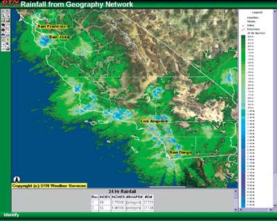
Real-time weather data such as rainfall estimates
are provided through the Geography Network.
Data courtesy of Meteorlogix LLC.
Meteorlogix' Geography Network weather offerings include high-resolution NEXRAD radar, surface data observations, rainfall estimates, and climatic statistics. Forecast data and historical event information will be added.
"Meteorlogix is helping to diversify how weather information can be used by thousands of innovators in numerous markets," says Jack Dangermond, president of Esri. "They already provide a number of ways to take advantage of this information in GIS format. The next generation of smart weather information for Esri users is here."
Industry Applications Abound
Many industry sectors are benefiting by merging weather data into their spatial data systems. And these efforts are spurring new applications. Shawn Truelson, Meteorlogix's GIS industry director, says the potential uses for this kind of technology are limitless. "People can see exactly what's happening to whatever area of interest they're responsible for. For instance, an insurance company can look at approaching weather and take a look at which of its clients will be affected and do property value calculations."
Integrating real-time weather information in a GIS-based transportation management system can help transportation organizations address their specific weather requirements. Traffic metering, road maintenance, rerouting, and fuel and safety management become more accurate when traffic managers use GIS to pinpoint which sections of a transportation system will be affected by a weather system.
Union Pacific Railroad uses a custom GIS-based track-warning network created by Meteorlogix. The system, which uses the MetWork FileServer and ArcView GIS 3.2, helps Union Pacific protect its employees from injury and equipment from damage and ensure timely service to its customers.
With GIS-based weather data, Union Pacific can monitor specific geographic locations for important weather conditions. When very exact predetermined weather conditions occur within a section of track, a dispatcher receives an immediate, fully automated alert. In October 2000, the system alerted Union Pacific to approaching high winds in Oklahoma. The dispatcher was able to stop a train and avert severe damage to both the train and tracks, which saved millions of dollars.
Accurate, Efficient Emergency Operations
Continuous real-time access to storm cell characteristics, including speed and direction of movement, intensity, presence and size of hail, and developing tornadic activity, is crucial to emergency management agencies.
GIS weather data can support modeling applications that enable emergency managers to make effective decisions and deliver faster response times during threatening weather. When population, transportation routes, and facility location layers are added to the data layers, they can pinpoint which people will be affected. Emergency vehicles can be rerouted to avoid flooded or damaged streets. Hospitals, schools, and high-risk residents can be notified in advance of a storm's arrival to prepare for it.
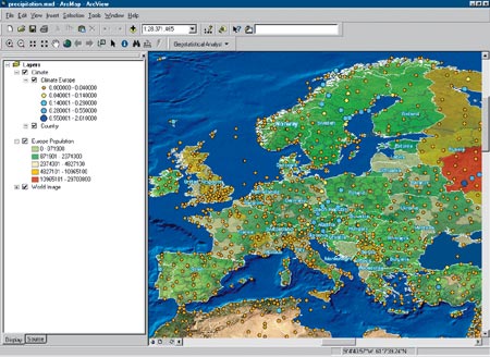
Now people can take weather data in a GIS format and use it to analyze the amount of rainfall over a watershed and calculate a food model or calculate the number of people within the path of a storm. Data courtesy of Meteorlogix LLC.
Weather data is also critically important when modeling toxic chemicals and other hazardous material releases in the case of a spill or even terrorist activity. Weather data collected locally and applied to GIS-based spatial plume modeling algorithms will produce much more accurate results than if general regional weather data is used.
Agriculture professionals who rely on accurate weather forecasts to optimize their harvests can use GIS-ready weather data for display and analysis. Georegistered weather information within a GIS can accurately map and calculate weather parameters for sections of cropland. Mapping accumulated precipitation from radar rather than using rain gauges enables the agricultural community to easily and quantitatively evaluate the space and time variations of rainfall.
High-resolution weather forecast information is available to electric utilities for merging into their operations. The forecast data derived from numerical weather prediction models at the National Center for Environmental Prediction is available in Esri grid formats. This data can be used to generate population and industry density-weighted calculations of energy load versus forecast temperature for potentially more realistic energy load forecasts. Improved energy load forecasts can help avoid power shortages and enable utilities to be competitive when buying and selling excess power on the national grid.
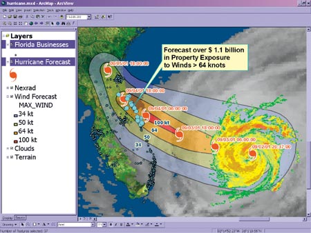
Meteorlogix's GIS weather data can be analyzed within ArcGIS to determine potential loss risks during a catastrophic event. Data courtesy of Meteorlogix LLC.
Meteorlogix also provides Esri-formatted national lightning information from Global Atmospherics Incorporated. Electric transmission operators will find this information useful for tracking problems along transmission lines. And the exact calculation of lightning strikes relative to outdoor recreation activities, fuel storage facilities, and other sensitive areas will be helpful to emergency managers.
In the health arena, Multidata, an environmental consulting firm, specializes in the study of the relationship between weather, climate, and the biology of the atmosphere. The company uses Meteorlogix' GIS-enabled weather data to produce pollen forecasts for use by major pharmaceutical companies and the media. "They get reports from their pollen collection stations and feed that into their model along with weather, predicted and current, and build their forecasts," says Truelson.
Introducing weather data to the powerful realm of GIS analysis and visualization is enabling users to do things they've never done before. The implications are boundless.
For more information, contact Shawn Truelson, GIS industry director, Meteorlogix, LLC (tel.: 952-890-0609, fax: 952-882-4500, e-mail: shawn.truelson@meteorlogix.com, Web: www.meteorlogix.com).