
Spotlight on San Diego Sector's Dedicated GIS Team
U.S. Border Patrol Maximizes Enforcement with GIS
 The United States Border Patrol has its hands full. With more than 8,000 miles of U.S. border to patrol and protect, these agents can certainly benefit from high-tech tools to help them get their jobs done.
The San Diego (California) Sector of the U.S. Border Patrol--which is responsible for 60 miles of tough terrain, 900 seismic sensors, and more than 2,000 agents--has some of the most diversified working conditions of any sector within the patrol. Many technological advances have come to the aid of the San Diego Sector--for example, infrared night vision equipment, air support, and seismic sensors. Perhaps one of the most powerful tools, however, is GIS.
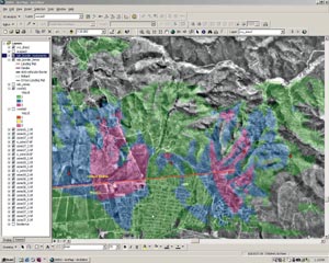
Below left: Viewshed analysis in ArcEditor 8.1. This is the technique used to analyze the placement of cameras and infrared scopes.
 The Enforcement Technology Office of the San Diego Sector feels that GIS assists the agents in fulfilling their mission much more effectively. "The Enforcement Technology Office is using GIS to maximize enforcement effort with regard to alien smuggling, border safety issues, and resource development," says John Block, agent and supervisor of the Enforcement Technology Office. "Through analysis of our apprehension data, we are now able to form a more complete picture of smuggling and other activities along the border."
Because most of what these agents do has a spatial nature (e.g., alien apprehensions, zone boundary identification, and determining locations for seismic sensors), GIS is a logical tool for resolving many of the issues involved in completing these tasks. GIS is a new tool for the Border Patrol, but the use of Esri's GIS product suite is increasing rapidly.
Running on Hewlett-Packard NT machines, the ArcView product line solves many of the problems the agents encounter in their day-to-day duties. The Enforcement Technology Office is the group responsible for putting together the system that gives the agents the information they need daily to get their jobs done. The team, made up of Border Patrol agents and enforcement officers, has the responsibility of incorporating and maintaining the most up-to-date technological implementations.
 Each of these team members brings a specialty to the table. It is important to recognize that a successful GIS includes personnel dedicated to understanding the task and the technology. Not only do these agents have the skills needed to patrol our nation's borders, but they are also experts at Web design, database operations, and Visual Basic for Applications (VBA).
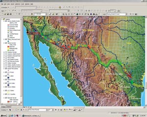
Above right: National map used to find trends on best times and positions to allocate resources for search and rescue efforts. GIS has been making a major impact in studying types of incidents vs. time of year and weather.
The San Diego Sector has fully embraced the GIS tools. To tackle the rough terrain of the mountainous areas around the sector, ArcView Spatial Analyst and ArcView 3D Analyst help the agents model the terrain for steep slope and cross-country mobility. By creating cost surfaces, the agents are able to determine the best route from one point to another. These points may be areas of apprehension, which is why it is vital that the agents get there quickly and without too much cost. In addition, ArcView and ArcView Tracking Analyst are used in conjunction with the Intelligent Computer-Aided Dispatch (ICAD) system to track sensor information and feed real-time intelligence on potential illegal immigrant paths to agents in order to allocate resources.
Dan Isenberg, Border Patrol agent and the GIS lead, says, "With the evolution of the real-time ICAD system, agents have situational awareness prior to their deployment into the field. Utilizing GIS with a cost path grid and trend analysis, agents have the ability to place themselves in a location to more effectively interdict alien traffic."
Each sector has field stations to gather intelligence on what is happening in their sector. Each of the stations in the San Diego Sector is equipped with ArcView plus extensions and a dedicated person to handle the GIS requirements.
 The Enforcement Technology Office will be installing ArcExplorer in each of these stations to assign latitudes and longitudes to apprehension points. These are entered as events, which are matched up with a tabular data set that is called ENFORCE. ENFORCE keeps track of data such as fingerprints and biological information on drug traffickers. By splicing together the latitude/longitude assignments from ArcExplorer and the information gathered from ENFORCE, the agents are able to plot the results in ArcView, and then run density analysis and filters on the seamed data. The end results show patterns of trafficking so that the enforcement of antismuggling efforts can be done more efficiently and effectively. The Enforcement Technology Office is currently working on a plan to Internet-enable this by using ArcIMS.
Above left: Query analysis is used to find smugglers' identification and trends based on geographic and temporal patterns.
The Enforcement Technology Office not only serves the San Diego Sector, it also supports operations nationally and regionally using ArcView and GPS. If there is a large-scale GIS project that needs to be done for the eastern region, for example, the Enforcement Technology Office will be called upon to handle the project because it has a dedicated GIS team. Each sector within each region has GIS capabilities, and all are moving to Esri technology. The hope is that eventually each sector will mirror the San Diego implementation. The Enforcement Technology Office is working hard to transfer technology knowledge to all the regions in hopes that GIS will be fully adopted.
Data sharing is another of the Enforcement Technology Office's future goals. With the recognition that crimes occur across zones and boundaries, the office is trying to pull together interested parties in law enforcement agencies other than the Border Patrol. The Enforcement Technology Office has already gathered information from the City of Chula Vista and plans to seek more geocoded data in the future.
For more information, please contact Daniel Isenberg, Border Patrol (tel.: 619-216-4198), or Wayne Sweeney, Esri-Washington, D.C. (tel.: 703-506-9515).