


|
|
||
|
|
|
|
|
|
ArcInfo 8 Embodies Modern GIS Theory So GIS Can Use DBMS Technology for Managing DataIntroducing the GeodatabaseArcInfo 8 makes sophisticated GIS easier to use and incorporates the latest concepts of GIS theory. The Summer 1999 issue of ArcNews included a special eight-page section that specified the features of ArcInfo 8 and introduced three new applications. ArcMap is the map-centric application for editing, displaying, querying, and analyzing map data. ArcCatalog is the data-centric application that locates, browses, and manages spatial data. ArcToolbox is the environment for performing geoprocessing operations.
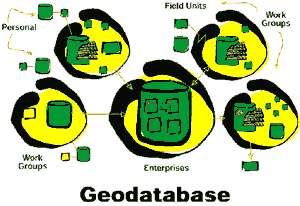
The chief purpose of this new object-oriented data model is to make it easier and more intuitive to use ArcInfo across many application areas. The geodatabase model achieves this by letting you add intelligence to features in your data sets in the form of behavior, properties, and relationships. In addition to generic features, such as points, lines, and areas, you can create features that more closely resemble the real world such as parcels, buildings, and transformers. According to Bob Parlock, the director of engineering products development for Telecordia Technologies, Inc., "The new object-oriented data model is superior to the old in that we can work directly with actual domain objects rather than just simple rows in a table." A geodatabase is a physical store of geographical information inside a relational database. You can implement multiuser geodatabases or single user, personal geodatabases. A personal geodatabase is stored in Microsoft Jet Engine (the format used by Microsoft Access). Available as an ArcInfo 8 extension, ArcSDE 8 can manage large sets of geographic data and serve large numbers of viewers and editors. ArcSDE allows ArcInfo to manage geodatabases on a variety of database platforms including Oracle, Microsoft SQL Server, Sybase, and Informix. In ArcInfo 8, you can view, manage, and create geodatabases with ArcCatalog and map and edit them with ArcMap. ArcToolbox also contains tools for converting other data formats to geodatabases. Some of the benefits of the geodatabase data model are
"ArcInfo 8 continues to support all existing Esri file formats and adds the new geodatabase format," says David Maguire, Esri director of product planning. "Users can keep their data as coverages or use the new geodatabase format if they want to take advantage of its advanced capabilities." You can learn more about ArcInfo 8 and the geodatabase by signing up for the free Virtual Campus course titled Introducing ArcInfo 8 at Esri Training and Education. ArcInfo 8 will soon be available and supports Windows NT and UNIX platforms. For more information on ArcInfo 8, please visit Esri online at www.esri.com/arcinfo, or contact Esri at 1-800-447-9778. Outside the United States, please contact your local Esri distributor. |
 Just as significant as these three new ArcInfo 8 applications is the newly introduced object-oriented data model called the geodatabase model--which is added to the existing georelational model (i.e., coverages and shapefiles with attributes) and increases data model flexibility.