
From Planning to Implementation
Cook County GIS Makes Steady Progress
 Cook County, Illinois, is working toward implementing a land records management system that is going to revolutionize both its internal operations and the services it provides to the public.
As reported in ArcNews (Winter 1999/2000), in 1999 the Cook County Assessor's Office awarded Esri a $15 million contract to manage 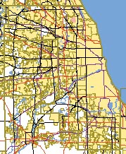 the implementation of a GIS that would give both County departments and the public access to current, consistent land information.
The project has now advanced from the planning to the implementation stage. A prototype of the system has been set up at Esri headquarters in Redlands, California. Hardware for the system has been purchased and installed, standard relational database management system (RDBMS) and GIS software have been installed, and portions of the custom GIS software were demonstrated in December 2000. County staff will soon be able to access the system in Redlands through a secure Internet connection.
With a population of 5.2 million, Cook County is the second most populous County in the country (after Los Angeles). Except in its northwestern portion, the County is almost entirely built up. The County's 1.6 million parcels are represented on 8,800 tax maps.
 To improve service and efficiency, the County, led by the Assessor's Office, embarked in 1998 on three concurrent modernization efforts: implementing a GIS, creating an office automation system to modernize the County's property tax records, and acquiring digital property imagery.
Esri is responsible for implementing the GIS, and since both the digital images and the digital documents generated by the office automation system will be related to the data in the geodatabase, the implementation of the GIS is in effect driving all three efforts. The property imagery is being captured from a van that is currently traveling the County's 8,000 miles of streets to acquire digital video images of every property in the County.
The prototype hardware and the core software for the GIS have now been installed. Specifically, a series of IBM Netfinity Servers have been installed with ArcGIS 8 software including ArcInfo, ArcView, ArcSDE, and ArcIMS. This hardware and software form the core of the system, with custom Esri software to be completed and installed in 2001.
The system is designed using a three-tiered architecture:
- Client (presentation) tier—The client tier consists of three software configurations and runs on different workstation configurations depending on the type of user:
- The heavy client provides ArcInfo 8 functionality (specifically, ArcMap and ArcCatalog).
- The medium client provides ArcView functionality.
- The light client provides Internet browser functionality.
- Middle (Business) tier—The middle tier software consists of database access and transaction processing software based on Microsoft Transaction Server (MTS).
- Database tier—The database tier software consists of ArcSDE and the relational database software.
Esri's ArcGIS software satisfies the requirements of many current and future Cook County users out of the box (i.e., without the development of custom code). Other Cook County users need custom software, which is currently in prototype form. The custom software, like standard Esri software, is object-oriented; object-oriented software is becoming standard for the industry, because individual software modules (or objects) can be customized for particular users (clerks, draftsmen, division writers, etc.), maintained independently, and still interact successfully with one another.
The effectiveness of object-oriented software depends partly on how accurately user needs are understood. 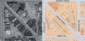 To allow the custom code for this project to be developed as efficiently as possible, a new kind of project document, one defining Cook County's use cases, was prepared for this project.
Right: The planimetric basemap is derived from aerial photographs (left) and Assessor's Office tax maps. These blocks are northwest of downtown Chicago.
In addition to installing hardware, standard software and developing custom software, this project calls for Esri to develop an extensive spatial database that will serve as the foundation of the modernization effort. The base for the County-wide GIS will be a planimetric basemap containing street centerlines, road edges, railroads, and hydrographic data. Referenced to this accurate planimetric base will be a cadastral database consisting of all data currently contained on the County's tax maps including parcels, lots, subdivisions, blocks, rights of way, and associated annotation. Production of the planimetric and cadastral databases has been under way for several months.
Although the database will not be completed until early 2002, the operational system, including hardware, core software, and custom software, is scheduled to be rolled out in the third quarter of 2001. The Cook County government and the public will be able to access land information via the Web.
For further information, please contact Charlie Wells, project manager, Esri (tel.: 909-793-2853, ext. 1-2126, e-mail: cwells@esri.com).