
Fliers and Explorers Globe Signing Ceremony
Explorers Honored by American Geographical Society
On December 11, 2000, Neil Armstrong and five other holders of exploration records signed the American Geographical Society (AGS) Fliers and 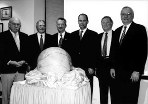 Explorers Globe at the Wings Club in New York City. Established in 1851, AGS is the oldest professional geographical organization in the United States. It is recognized worldwide as a pioneer in geographical research and education.
Over the past century, more than 60 famous fliers and explorers, such as Charles Lindbergh and Sir Edmund Hillary, have signed the globe and drawn the routes of their exploits on it. The new signers on this occasion were
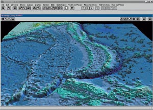
- Don Walsh, who, with Jacques Piccard, dove in 1960 to the bottom of the Marianas Trench in the Pacific Ocean—a record depth of 35,800 feet.
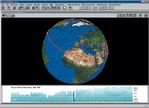
Below right: At 35,800 feet in depth, the Challenger Deep is almost seven miles deep. As a comparison, it is almost a mile deeper than Mount Everest is high. In the upper left is Japan. - Brian Jones and Bertrand Piccard were the first fliers ever to circumnavigate the globe by balloon in 1999.
Below left: ArcView GIS shows Jones and Piccard's globe circumnavigation route. Underneath the globe is an elevation chart for each of their 21 days in the air. - Walter Pitman and William Ryan, who explored the Black Sea floor and discovered a massive flood that occurred there about 7,500 years ago, possibly explaining Noah's flood. Ryan and colleagues also discovered a similar inundation in the Mediterranean that occurred five million years ago.
- And, of course, Neil Armstrong was the first person to set foot on the moon, helping to change the human view of earth and space.
Esri Presentation
 Part of the globe signing ceremony included an exciting GIS demo/presentation using ArcView GIS. Jerry Dobson, director of exploration of the AGS and senior development staff member at Oak Ridge National Laboratory, helped organize the presentation of the explorers' monumental achievements with a dynamic and exciting visualization using ArcView GIS, including a "fly-by" into the Marianas Trench, the route of Jones and Piccard's circumnavigation of the globe, the flooding of the Mediterranean and Black Seas, and Armstrong's orbits around the moon and subsequent lunar landing. Video was also embedded into ArcView GIS to provide actual footage of each of the events to help the audience envision what each of the explorers saw and experienced as realistically as possible. Afterward, speaking about the presentation, Dobson said, "The presentation was a smashing success with many prominent people introduced to GIS in an imaginative way."
For more information about the AGS or the Fliers and Explorers Globe, contact Jerry Dobson, Oak Ridge National Laboratory (tel.: 865-574-5937, e-mail: dobsonje@ornl.gov).