
GIS Day 2000 Is a Worldwide Triumph
November 15, 2000, marked the second global GIS Day. With thousands of local events held in 81 countries, millions of children and adults were educated on the benefits of geography and the role that GIS plays in its support of geography. While the sponsors of this event continue to provide leadership, it appears that GIS Day is more and more taking on a life of its own with many unaffiliated GIS events by many types of organizations, even some on different days. The following are descriptions of a few of these events.
Elementary School No. 311, Bucharest, Romania
During a symposium dedicated to GIS Day this year, eight pupils from Elementary School No. 311, Bucharest, Romania, shared an application, called "The House of my Childhood," that involved a presentation about each of their grandparents' counties (Mures, Arges, Prahova, Mehedinti, Neamt, Braila, Tulcea, and Buzau), which are the places they have spent their holidays. The routes they chose in each county are some of the most important routes in Romania. The software used was ArcView GIS 3.2 for Windows and PC ARC/INFO 3.5.2. Their project was coordinated by their geography teacher, Professor Miloiu Steliana, and the symposium was sponsored by the Romanian Esri distributor (Esri Romania S.R.L.).
There were 20 geography teachers from all over Bucharest who took part in this symposium, along with the staff of Esri Romania, the school inspector for districts 2, 3, and 5 of Bucharest, and the Romania 1 national television post.
For more information, visit www.gisday.com/gisday/success2000/event226.html.
The City of Solon GIS, Ohio
The City of Solon Geographic Information System (COSGIS) was incorporated into the Annual KIDS CITY program organized by the Planning Department in the City of Solon, Ohio. KIDS CITY, held November 6-9 with an open house on November 14, was an opportunity 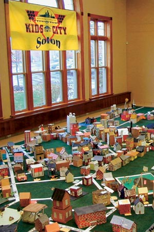 for the third graders to learn how cities are planned and how, consequently, to construct a one-quarter-inch scale community. This was the fourth year of KIDS CITY and the first year utilizing GIS, which coincided nicely with GIS Day.
About 400 third grade students from the four elementary schools participated in this year's program. Another 120 students from Solon High School's senior government class also participated.
At right and below: The final layout of the City of Solon's KIDS CITY in both miniature and GIS versions.
Each elementary school was responsible for the development of a 50-year time period in the community history. One class started with a blank landscape except for the main crossroads of the community. As the community grew, high school students assumed the roles of mayor, city council, and planning commission to guide the growth of the City through such problems as determining how new streets were to be laid out, proposing new zoning codes, and working with proposed City ordinances. Other positions held by the high school students consisted of planners, building officials, engineers, and architectural review board members.
The students were provided with a list of the types of development that might be appropriate for their time period. Construction of courthouses, fire stations, jails, carriage factories, farmhouses, gas stations, malls, airports, and whatever else makes up a community, past and present, became the children's assignments.
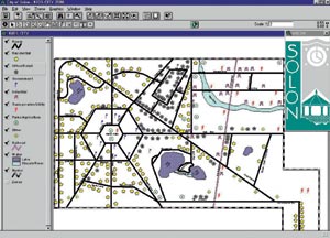 The buildings, roads, and water bodies were added into the COSGIS ArcView GIS system with the intent of allowing the growth of the City to be viewed in real time. Once a building was placed or a street approved and placed, COSGIS made instant updates on the map within ArcView GIS. This allowed for the mayor, city council, and planning commission to have up-to-date information on the layout of the City and how it was progressing.
For more information, contact Paula Brumbelow, planning ombudsman (tel.: 440-349-6327). For information on the City of Solon GIS, contact Andrew Faley, GIS coordinator (tel.: 440-349-6745).
GeoLogic at Sachsenbrunn High School Near Vienna, Austria
This GIS Day project was a collaboration between GeoLogic's Dr. Josef Benedikt and Christian Handler, a geography teacher from Sachsenbrunn High School. Dr. Benedikt has specialized in GIS teaching and offers workshops on a K-12 level as well as for adult education.
Sachsenbrunn High School is located 100 kilometers south of Vienna, Austria. The reason for choosing this topic was the change of Sachsenbrunn High School from a boarding school to a public school, thus the origins of students changed. Sachsenbrunn's students today come from local communities. The GIS students spent a lot of time locating their fellow classmates according to the regional boundaries of ArcData files. The results of this project led to a different attitude toward collecting data in the future.
The results were summarized in a poster and presented at a school event on November 14, since November 15 was a public holiday in lower Austria. The project was reviewed in local newspapers and made it to the Web site of www.gisday.at.
The Nature Conservancy, Arlington, Virginia
The International Conservation Science Department of The Nature Conservancy in Arlington, Virginia, celebrated GIS Day 2000 with multiple events. Staff members from the home office of The Nature Conservancy had several opportunities to become more exposed to and learn more about GIS and its uses in conservation around the world. The event offered staff members several opportunities to learn about ArcView GIS and its uses in conservation. A map gallery was displayed in the building lobby, greeting Conservancy staff and others entering the building. The day also included an introductory course on GIS for those with little experience using GIS.
As closure to an already very successful GIS Day at the home office of The Nature Conservancy, the Conservation Mapping Center opened its doors to the entire building and had a GIS Lab open house. Some staff, who had not been able to join the training earlier, visited the lab to see what types of maps are often used for conservation purposes in the International Conservation Program. Several maps were displayed including the vegetation and land cover of Jamaica, Puerto Rico, and Dominica; and the results of a joint pilot project between the EROS Data Center, the International Institute of Tropical Forestry, and The Nature Conservancy to map the vegetation in the Caribbean. Other maps on display included the vegetation and elevation of Latin America and the Caribbean (LACR) and Africa, as well as the ecoregions of LACR and Africa.
For more information, visit www.gisday.com/gisday/success2000/event1712.html.
McMaster University, Hamilton, Ontario, Canada
McMaster University's GIS Lab in the School of Geography and Geology hosted a day-long GIS Day event specifically aimed at educating high school students from local areas. The Ontario Ministry of Education introduced GIS into the high school geography curriculum in September 1999. To assist in teaching GIS to the students, undergraduate and postgraduate volunteers taught approximately 150 high school students (from eight high schools) hands-on ArcView tutorials throughout the day.
In addition, the program included the following presentations:
- Introduction to GIS
- Careers in GIS
- Multidisciplinary Applications in GIS
- GIS and Public Health Mini-Conference
- GIS Education at the High School Level
The presentations consisted of GIS research in resource management activities, statistical significance of geographic clusters, spatial and temporal variation of asthma morbidity in Canada, analysis of cardiovascular disease hot spots in Ontario, and environmental effects in the Great Lakes Basin.
The "GIS Education at the High School Level" presentation consisted of a hands-on ArcView tutorial for teachers and contributions from the Esri K-12 Program, Let's Talk Science, and the McMaster University GIS High School Outreach Initiative. A poster competition was held with entrants from Hillfield-Strathallan College in Hamilton, Ontario.
Approximately 200 faculty, staff, and students attended this successful day. For further information and images of this event, please refer to www.science.mcmaster.ca/gislab/gisday2000/gisday_2000.html.
Kootenai County, Idaho, and Medical Lake, Washington
GIS Day 2000 was a smashing success at the University of Idaho Research Park in Post Falls, Idaho. Cosponsored by SpatialTek (Post Falls, Idaho) and Esri Business Partner Ascent GIS (Spokane, Washington), more than 100 students, teachers, and interested citizens attended the event from five participating Kootenai County, Idaho, schools, as well as a class that came all the way from Medical Lake, Washington. CEOs Rick Lovel and Mike Mcguire of the two companies interacted one-on-one with the students all day showcasing the latest in Esri technology. Twelve computers featured hands-on projects generating much excitement among future geographers.
The main attraction was the virtual map of the local Centennial Trail, created by three students from the Riverbend Technical Professional Academy. The events were featured four times in local publications. The Spokesman Review of Spokane, Washington, ran an article about the event as well as an article before GIS Day specifically announcing the event. The same happened with The Couer D'Alene Press. It ran a pre-event article and a nice, larger article afterwards.
For more information, visit www.spatialtek.com/spatialtek/maps/maps.htm.
Riding the GIS Train, Trenton and New Brunswick, New Jersey
Train travel is one of the most vivid ways of experiencing geography. That is why it was chosen as the theme around which to develop this year's GIS Day by participating New Jersey offices. Two 5th grade classes participated—one from Grant Elementary School in Trenton, New Jersey, and the other from Roosevelt Elementary School in New Brunswick, New Jersey. The day was split between exploring mapped information with GIS and riding a train to identify the mapped features in reality.
Students from Trenton started in the GIS lab at the New Jersey Department of Environmental Protection. Students from New Brunswick started in the computer lab at the Bloustein School of Planning and Public Policy at Rutgers University. In the morning they had a brief introduction to GIS and hands-on exercises with the ArcView software. They identified the train line between New Brunswick and Trenton and then used aerial photography to identify seven sites that could be seen from the train. These included man-made structures (parking lots, schools, and industrial buildings) and natural features (woods and wetlands).
After this introduction, students from the two schools traded places by taking the GIS train, courtesy of New Jersey Transit. Trenton kids went to New Brunswick and New Brunswick kids went to Trenton. While on the train, they tried to identify the seven sites they saw in the aerial photographs. Answers to the identification problems were discovered when they reached their destinations. A second set of hands-on exercises were completed after the train ride, using GIS to explore the urban and natural environment of their destination or home city.
Support came from employees and students of New Jersey Transit, Rutgers University, New Jersey Department of Environmental Protection, New Jersey Office of State Planning, and New Jersey Office of Information Technology. For more information, contact Angela Witcher of the New Jersey Department of Environmental Protection (e-mail: awitcher@gis.dep.state.nj.us) or Lyna Wiggins of Rutgers University (e-mail: lyna@rci.rutgers.edu).
HNIT-Baltic GeoInfoServisas, Vilnius, Lithuania
HNIT contributed again to GIS education and knowledge dissemination by organizing the GIS Day 2000 event in its office and promoting it during an annually organized IT Baltic exhibition, Infobalt 2000. As a result, more than 40 students studying geography, engineering, and hydrology were welcomed from different Vilnius universities. In addition, 40 land reclamation specialists from all over the country showed great interest in seeing extensive GIS application measures. GIS Day 2000 events were also organized by the Institute of Aerial Geodesy, Ltd., in Kaunas, where the total number of visitors reached 140; and the Siauliai Gas Company "Siaures dujos" in Siauliai, where the total number of participants was 45. Moreover, GIS Day 2000 was supported and organized by other Lithuanian companies including GIS Centras in Vilnius, which introduced an exciting idea of encouraging people to make a map of their own using ArcExplorer; Bite GSM, Ltd.; and Anyksciai City Municipality.
For more information, visit www.hnit-baltic.lt.
The City and County of Wilson, North Carolina
The City and County of Wilson cosponsored GIS Day 2000. GIS classes were taught at every high school in the County, and GIS activity booklets were provided to nine elementary schools and one day care center. A GIS documentary was also videotaped that aired on cable channels throughout North Carolina. Additionally, the Wilson Daily Times ran a story on GIS in its education section. Lastly, map galleries were established in City and County lobby areas. It is estimated that Wilson educated more than 500 children within its community. More than 650,000 households had access to view the GIS documentary.
For more information, contact Nathan Mark Wells, City of Wilson, North Carolina, GIS coordinator (tel.: 252-399-2158, e-mail: nmwells@wilsonnc.org).
Kuala Lumpur, Malaysia
PLUS is the concessionaire for the North-South Expressway in Malaysia. This year, the GIS Unit at PLUS organized an event to celebrate GIS Day 2000. Fifty-one students ages 13 to 15 years old from four schools signed up for the event, accompanied by six of their teachers. A full program of activities was planned for the children including a drawing competition, do-and-learn exercises, an ArcView demo, and, of course, a presentation on GIS and GIS Day. Maps of the North-South Expressway were also displayed at the map gallery, which attracted additional visitors comprised of members of the public and the press.
For more information, see www.gisday.com/gisday/success2000/event301.pdf.
GIS Day 2001
GIS Day 2001 is Wednesday, November 14, 2001. Please check the GIS Day Web site (www.gisday.com) to learn more about upcoming plans and register to host a GIS Day 2001 event.