
Data and Knowledge to Affect Public Policy
GIS Gives Foresters a Better Way to Look at Trees
Founded in 1875 by citizens concerned about the waste and abuse of the nation's forests, American Forests is the oldest nonprofit citizen conservation organization and has led the way in developing new approaches to conservation. With a mission to help people improve the environment with trees and forests, American Forests sponsors many national and international tree planting, forest policy, and urban forestry programs.
A Smart Investment for Any Community
In addition to the awe-inspiring beauty of trees, there are many tangible benefits derived from maintaining healthy forests. Forest conservation is a smart investment for any community because trees protect watersheds, reduce stormwater runoff, lower energy consumption, provide recreational opportunities, reduce air pollution and global warming, cool urban areas, and offer wildlife habitats.
Ecologists at American Forests' headquarters in Washington, D.C., have spent more than 20 years studying the condition of urban and suburban forests. They have observed a dramatic decline in urban tree canopies as urban sprawl gobbles up tree after tree in the name of progress.
To help reverse this trend, American Forests, an Esri Business Partner, has launched an ambitious five-step program that encourages a grassroots approach to affecting public 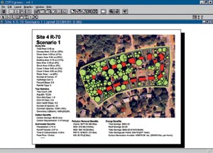 policy by ensuring substantial tree canopy coverage in communities. To accomplish this, researchers use imagery to analyze existing conditions and establish their monetary values and then provide information and tools for decision makers to use.
The first step in American Forests' plan to combat urban sprawl is for communities to assess their tree canopy cover, which is a proven indicator of a healthy and sustainable urban ecosystem. Informed decisions that take the value of natural resources into account can save cities money and help to integrate the built environment with the natural environment.
To help cities uncover the hidden value that trees and greenspace provide, American Forests developed a GIS analysis technique called the Regional Ecosystem Analysis (REA). The process uses satellite data, field surveys, CITYgreen software, which is bundled with Esri's ArcView GIS, and several other Esri software products such as ArcInfo, ArcView Spatial Analyst, ArcView Image Analysis, and ArcView 3D Analyst.
Gary Moll, a forester and vice president at American Forests, helped to design the techniques used in REA. "We were studying urban ecosystems, and we wanted to come up with a better way of quantifying this important resource. Our better way was GIS technology," Moll says. On selecting the software tools for the effort, Moll has this to say, "We had so much good guidance and support from Esri, plus the software is so good, we just never thought about anything else."
"As we looked at these urban forests, we wanted to evaluate a 20-year period of change, so we used Landsat imagery. This involved large data sets, and ArcInfo was the perfect tool for this," he says. In some cities, especially in the West, Moll saw that the tree coverage actually increased, but nowhere near the extent to which pavement had. By applying a stormwater engineering formula, he determined that the cities were "producing a lot more stormwater, their air quality was going down, and the heat was going up." Moll says, "To balance that out, you can figure out the percentage of trees they ought to put in to change the ecology. The cities can let the trees do the work for them."
Making a Point—Region by Region
REAs are big, complex analyses, and American Forests has conducted them in many areas throughout the country. Visitors to the American Forests Web site (www.americanforests.org) can download the full reports and images. These REAs document how tree losses are costing communities billions of dollars.
For example, the REA for the Chesapeake Bay Region and the Baltimore-Washington Corridor states that tree loss "from 1973 to 1997 resulted in a 19 percent increase in runoff." The urban forest in 1997 provided about $4.68 billion in stormwater retention capacity. If the trees lost since 1973 were replaced, that value would be at $5.7 billion.
The REA for the Puget Sound Metropolitan Area found that natural tree cover declined by 37 percent from 1.64 million acres to 1.04 million acres. The lost trees each year would have removed 35 million pounds of air pollution at a value of $95 million.
A recent REA in Garland, Texas, has concluded that the City's tree cover reduces stormwater runoff by 19 million cubic feet during a major storm event. The tree canopy stores approximately 209,000 tons of carbon and removes 497,000 pounds of carbon. In terms of stormwater and air quality, the value of Garland's existing urban forest is estimated at $5.3 million annually.
Community activists can take the REA findings to their decision makers to promote new planning and zoning ordinances, preserve urban greenspace, and educate citizens and the media about the value of natural resources. The REAs provide concrete information about the environment in practical terms. They show how changes in the environment are related to budgets.
For additional information, contact Steve Walsh at American Forests in Washington, D.C. (tel.: 202-955-4500, ext. 227; e-mail: swalsh@amfor.org).