|
GIS in Kruger National Park, South Africa
Xamina Xawena
(It is mine; it is yours)
The above is a Shangaan expression and the theme for the Kruger National Park's centenary celebration (1898 to 1998).
 Kruger National Park (KNP) celebrated its centenary this past year. In keeping with the new South African democracy, the park has embarked on a process of transformation and affirmative action. This provides the vision that all South Africans have a joint stake in and stewardship of the KNP--it is theirs and ours. People throughout South Africa as well as the rest of the world are being welcomed to "come share our heritage." Kruger National Park (KNP) celebrated its centenary this past year. In keeping with the new South African democracy, the park has embarked on a process of transformation and affirmative action. This provides the vision that all South Africans have a joint stake in and stewardship of the KNP--it is theirs and ours. People throughout South Africa as well as the rest of the world are being welcomed to "come share our heritage."
This new drive of shared ownership and stewardship is also being vigorously promoted in the park's spatial information systems. Information system (IS) staff members at Kruger are embarking on a landmark project to build and integrate a Central Spatial Data Warehouse--GISCENTRAL--throughout the organization. It will be implemented in all departments, disciplines, and systems that are charged with managing this world famous national resource. In keeping with current IS trends it will make the appropriate maps and data available to the world via the World Wide Web. This vision obviously does not stop with the KNP but will eventually include all of the areas (about 20) currently under South African National Parks (SANP) control. It is hoped to also involve the local provincial and even private game reserves or natural heritage areas so that they too may participate in a Southern African Natural Areas Information System (SANAIS) and be "put on the map." Ambitious--yes! Impossible--no!
The KPN staff have been active in GIS for 10 years, using three or four mainstream products from various vendors to accomplish different "specialist" or "niche" tasks mostly in the ecological field and to a lesser degree for facilities management (FM). This approach, while serving these tasks well, has always been essentially a stand-alone system and has never taken part in a larger, enterprisewide Spatial Data Warehouse solution. Common map data has been shared by the traditional "sneakernet." More recently it has been shared by means of direct file transfer and E-mail via the Kruger local area network (LAN) and wide area network (WAN).
There has been a lot of synergy of ideas between the various specialists at the applications level, with the IS staff always being involved in technical matters--hardware, network and operating system support, application design and even GIS support. This led to a common goal among all involved; a central data repository had to be created and managed--preferably by IS. In 1996 the IS Division in Kruger took this need to corporate IS management and received a very tentative go-ahead for the project.
A start was made; Esri's ArcInfo was implemented on a UNIX platform; and a serious attempt was made by IS to gather, verify, convert, and then store all relevant baseline data layers in GISCENTRAL. These data layers consisted of "best of" natural themes (landscapes, land types, geology, rivers, drainage channels), operational themes (management blocks, veldt condition assessment plots, burn blocks), and man-made themes (roads, bridges, dams, rest camps and other visitor facilities, entrance gates and boundaries). ArcView GIS was implemented as a GIS tool for resident specialist staff, while some especially eager users made direct use of the ArcInfo system.
 Most of these users were researchers who came from overseas academic institutions to work on graduate or postgraduate projects. IS staff provided much assistance here. Derived layers and other map layers of interest were created using ArcInfo, converted to the required output format, and then transferred to the researchers' laptop computers for their further analysis and presentation in a variety of PC-based GIS packages, usually IDRISI and ArcView GIS. In early 1997, a GIS seminar was held in KNP to inform top management and the users of the progress and future directions of GIS in general and GISCENTRAL in particular. In mid-1997 Geographic Information Management Systems (GIMS), the South Africa Esri distributor, was commissioned to create a data set consisting of the topographic 1:50,000 map sheets for all of the SANP-controlled areas, which comprised more than 140 sheets, and was added to the ArcInfo system. A few CDs of this data set were distributed internally within KNP, the SANP head office, and the Cape Town regional office. And there things stood. Most of these users were researchers who came from overseas academic institutions to work on graduate or postgraduate projects. IS staff provided much assistance here. Derived layers and other map layers of interest were created using ArcInfo, converted to the required output format, and then transferred to the researchers' laptop computers for their further analysis and presentation in a variety of PC-based GIS packages, usually IDRISI and ArcView GIS. In early 1997, a GIS seminar was held in KNP to inform top management and the users of the progress and future directions of GIS in general and GISCENTRAL in particular. In mid-1997 Geographic Information Management Systems (GIMS), the South Africa Esri distributor, was commissioned to create a data set consisting of the topographic 1:50,000 map sheets for all of the SANP-controlled areas, which comprised more than 140 sheets, and was added to the ArcInfo system. A few CDs of this data set were distributed internally within KNP, the SANP head office, and the Cape Town regional office. And there things stood.
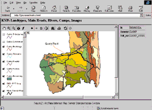
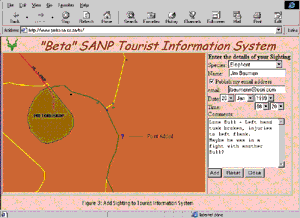
In 1998 extensive restructuring and transformation operations began within the SANP and the KNP. IS staff in Kruger again addressed the GISCENTRAL issue. "Suddenly the right software technology was there, we have a good network--LAN and WAN--in place, and spare hardware capacity is available. And without realizing it, we had, by a process of subtle informal lobbying and by the changes taking place within SANP and KNP, created a need among our users for Internet based GIS," comments Rob Clark, senior manager, IS Kruger National Park. "Our users are using E-mail, surfing the Web, and trying out some of the Internet WWW-based mapping facilities they either stumble upon or read about," adds Clark. "We immediately set to work and built two demonstration Internet-based systems using ArcView Internet Map Server (IMS) and ." He continues, "They are both relatively simple, test-drive applications--one being a query/lookup type system on existing ArcInfo KNP data and the second aimed at visitors to allow them to add their game sightings on a live Kruger map for others to query, say for where all buffalo had been seen on a particular day. The eventual goal here is to replace the traditional paper maps and colored pins currently found in each rest camp with a PC connected to our existing network."
Both systems have been successfully showcased via a short user awareness course to SANP management and potential users in the Kruger head office and the southern (Cape Town) region. GIMS played a major role in these events, which concentrated on industry trends, the importance of having a good spatial database, and the applications themselves.
"Awareness of Esri's software and GIS in general has been given a boost," said Clark. "We are now converting to ArcInfo for Microsoft Windows NT for professional GIS, ArcView GIS for our specialists and management who feel they want that level of flexibility, and IMS technology, including ArcExplorer, for the data users and viewers. All will operate with an SDE-enabled Microsoft SQL Server back end database."
The area earmarked for rapid deployment is Kruger's Technical Services department, which operates like a mini-municipality or local authority. They manage all man-made infrastructures within the park--roads, bridges, earthen and concrete dams, artificial water holes for game, visitor facilities (rest camps, gates, and the associated buildings and servitudes that go along with such "almost suburban" developments)--both in the construction and maintenance thereof. Thus, the labor- and cost-saving benefits of implementing an Intranet/Internet-based facilities management system, integrated into the existing SANP financial system, are enormous. "Our communication facility extends as a LAN/WAN from every camp in the KNP to Skukuza where GISCENTRAL is located, and from there on to the SANP Pretoria head office, and then countrywide as far as the recently proclaimed Cape Peninsula National Park (Table Mountain and surrounds) in Cape Town," states Clark.
Concludes Clark, "We intend to make as much available to our own staff and colleagues from other conservation bodies as soon and cost-effectively as possible, with the worldwide Internet audience following on, so that we can all proudly proclaim, 'It is mine; it is yours; come and share our heritage!'"
For more information, contact Rob Clark, Kruger National Park (tel.: 27-82-928-8463, fax: 27-13-735-5636, E-mail: RobC@parks-sa.co.za, clarkr@aqua.ccwr.ac.za), or Steve Hine, GIMS (Pty.) Ltd. (tel.: 27-11-315-0390, fax: 27-11-315-0395, E-mail: shine@gims.com).
ArcNews home page
|
|


