


|
|
||
|
|
|
|
|
|
Whirlwind of GIS Activity in NashvilleBy Arthur S. Bushing, P.E., Nashville Electric Service, Tennessee"Nashville Electric Service (NES), one of the 10 largest public electric utilities in the United States, began operations in August 1939. NES does not generate power. All electrical energy distributed to customers is purchased from the Tennessee Valley Authority, the nation's largest generator of electricity." (Quoted from "From the Director [Terry Cobb]" Metro Codes News, vol. V, no. 2, 1998.) NES has a service area covering about 700 square miles in middle Tennessee. Led by President and CEO Matthew C. Cordaro, NES's approximately 1,000 employees serve more than 300,000 customers in parts of seven counties from a central office and two outlying service centers in Nashville.
Given a mandate from top management to react "better and faster" next time, several key factors were addressed. Among them were
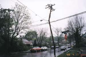
NES identified three vendors as being most appropriate to their situation. Such software uses mapped data and geographic and electrical relationships to infer outage locations and to tabulate numbers of affected customers. Talks with, and bid proposals from, these three companies revealed that two of the three based (at least parts of) their systems on ArcInfo software. Linda Bozza, Mapping Group leader in the Civil and Environmental Engineering Department of Nashville Electric Service, says that facility maps at the utility had evolved from 417 "ink-on-linen" sheets through several steps into AutoCAD maps. With the help of a GIS consultant, Nashville Electric Service chose to convert the 417 map tiles to ArcInfo format in-house rather than sending the data conversion out to contractors. With ArcInfo installed on one DEC Alpha 2000 server, a DEC Alpha 250 workstation, and three DEC Alpha 500 workstations, NES now has eight mappers and three GIS specialists utilizing ArcInfo. Each user has a 400 MHz PC running X Windows terminal emulation. NES completed the "seamless map" in October 1998. During the data conversion, which required working double shifts to complete, ". . . an F3 (severe) tornado struck Nashville with 158-206 mph winds. It touched down near Knob Hill and cut a nearly straight line of devastation three-quarters of a mile wide, from there through downtown Nashville, to Andrew Jackson's historical home, the Hermitage, 11 miles away. For 24 minutes it pounded the City, damaging 2,767 homes, 600 Businesses, and wreaking more than $100 million in total damages. Awed, silent observers agreed, a nearly mile-wide path through the heart of Nashville looked like a war zone." (Quoted from Fiscal Facts for Year Ending June 30, 1997. Nashville Electric Service.) It took NES a few hours to mount a storm response because the main operations building stood squarely in the path of the tornado and had, itself, lost power. Damage to electric facilities City-wide totaled about $8 million. Nashville Electric Service employees met the challenge head-on. Realizing that information is the key to directing action, employees surveyed the damaged parts of town and quickly identified those sections with severe damage. It was evident that some areas were beyond repair; those areas would have to be completely rebuilt after clearing away debris.
In eight days Nashville Electric Service restored or built new facilities to provide power to 75,000 customers, with more than 90 percent back in service within two days. A 69,000 volt transmission line, which had originally taken 18 months to construct, was rebuilt within those eight days. "These maps were used to identify crew locations and work areas vital to both planning and tracking construction progress," said Winston Smith, vice president of transmission and distribution operations at Nashville Electric Service. "The maps were a key element in the orderly restoration of service and communicating our progress to other utilities and agencies working in the area." For months after the storm effort was completed, maps were requested by governmental agencies, other utilities, and the Federal Emergency Management Agency (FEMA). One request even came in from a cable network television film crew who filmed a story about the Nashville tornado. After implementation of the outage restoration system is completed, Buri says that future GIS activities will focus on making the GIS data available to more users in the utility. "We plan to utilize Esri's ArcInfo, Spatial Database Engine (SDE), ArcView GIS, and possibly ArcFM to get more users in a common data environment," Buri said. For more information, contact Arthur S. Bushing, supervisor of mapping, GIS, and job order records of the Civil and Environmental Engineering Department, Nashville Electric Service, Tennessee (E-mail: abushing@NESPOWER.com). |
 In February of 1994, middle Tennessee was hit with the area's worst ice storm since 1952. As trees, limbs, poles, and service wires fell across the utility area, customer service lines began lighting up with outage reports. Calls came in such high volume that the entire Business process overloaded. Customers had difficulty reaching NES and did not stop calling for several days. After service was restored to all NES customers, the NES post-incident review pointed out several opportunities for improvement; one key area was information gathering and information transfer. NES needed a better way to locate and manage system problems.
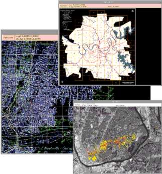 Using GIS, the group at NES (led by Mike Buri, project manager) was able to pull data from City land records stored in ArcInfo, electric facility records (with GPS locations) stored in Oracle data tables, and mapping information from AutoCAD DXF files to produce highly accurate maps of the affected areas, incorporating such features as areas of crew responsibility, damage level, and completeness of restoration. In seven days, the GIS group produced about 1,500 custom color maps in 24-inch by 36-inch format, keeping four Hewlett-Packard 650C plotters working around the clock. These maps were used by NES service crews, foreign (contracted from other utilities) crews, television stations, and the local police department to display and coordinate restoration work.