


|
|
||
|
|
|
|
|
|
Delivers Immediate UpdatesPhoenix Intranet Plugs Leaks in Water DepartmentStaff members at the City of Phoenix, Arizona, Water Service Department work hard to maintain the City's water and sewer infrastructure and keep accurate records of structural changes and revisions. However, getting the updates out to field personnel and other internal divisions that regularly need and use that information had turned into a bottleneck.
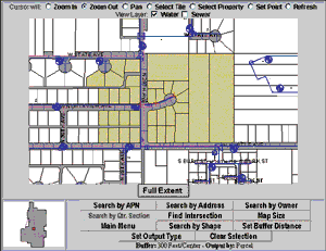
Now, equipped with Esri's MapObjects Internet Map Server (IMS), the Water Service Department's systems services area is dishing out fresh data to its remote offices in no time at all. Motivated by the need to improve the turnaround time and presentation quality of the data, the Water Service Department called on Esri-Denver for a solution. "They already had a wide area network to all the field service offices, and they wanted to take the latest data and serve it up to the field people," said Jeff Garland, applications developer at Esri-Denver. "When they saw a demonstration of the capabilities of , they realized they could get their database directly to the field via an Intranet." Garland built the Water Service Department a custom application that cuts the time it takes to get the data out to field service personnel from months to less than a day. Using the MapObjects Internet starter application templates, he adapted the application to integrate the water and sewer data, which is linear in nature rather than polygon based. "The bottom line was to port the starter application to their data structure and customize the application for different functionalities that weren't inherent in the templates," he said. Improving the FlowThe development and testing stage for the application started in the summer of 1998 and ended within a few months. The software uses and SDE as well as incorporating Visual Basic and HTML for the creation of the pages. SQL requests retrieve land information data for display or download. Running on the Water Service Department's Windows NT server, the system connects to the City's UNIX Web server and GIS data. The application enables users to view a variety of water and sewer data including parcel ownership and facility information. Field personnel can search for an address, assessor parcel number, street intersection, quarter section, and owner name. Other features identify attributes on each layer. All of the property records information have PINs that are linked to SDE. Screen prints provide users with hard-copy output. Another unique aspect of the application enables users to create mailing labels of defined areas. These labels are helpful for notifying customers about service interruptions and other events. Users retrieve the mailing label information in a Microsoft Excel spreadsheet within the browser. More than half of the department's remote sites already have the new application up and running. Terry Dorschied, the Application Development Team supervisor at the Water Service Department, said that his group is still in the process of training personnel and testing some of the connections to the field offices. Dorschied said the decision to go with this software was inspired by its time- and money-saving qualities. "We went with MapObjects Internet Map Server because we wanted to provide desktop access to our internal customers--water collections, water distribution, customer service, and development service. They all use our maps for their Business, and because it's HTML they can plot whatever is on the screen. "One of the things that's nice about the application is all you need to have is Microsoft's Internet Explorer, which everybody at the City already had. We didn't have to buy a lot of software to enable a lot of people to view our maps," Dorschied continued. For more information, contact Terry Dorschied (tel.: 602-256-4277, E-mail: tdorschi@ci.phoenix.az.us). |
 Linked to the City's enterprise GIS database, the department had no problem sending updates to Spatial Database Engine (SDE), but disbursing the revised data to the 27 water and wastewater remote sites was another matter. That involved copying quarter-section maps to microfiche and then distributing the film. The process often took several months, and the mechanisms for viewing the maps were inferior. When the field crews finally got the microfiche, the data on it was old. Frustrated with the stale information they were left to work with, field operators resorted to traveling to the department's headquarters to retrieve the latest information--at the additional expense of time and money.