


|
|
||
|
|
|
|
|
|
An Overview of the Geography NetworkAs more and more people begin to see the value of using geographic thinking to structure their organization and solve their problems, the need for easy access to geographic information continues to rise. The demand for geographic information is already outstripping our ability to supply it as files on CDs and other digital media. Many people see the Internet as the only feasible way to meet accelerating demand for geographic and other information. 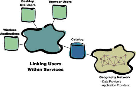 The Geography Network is a global network of geographic information users and providers. It uses the infrastructure of the Internet to deliver geographic content to user browsers and desktops. Content may be provided in the form of raw data, maps, or more advanced services dealing with, for example, lifestyle mapping, flood risk mapping, address geocoding, and network routing. The Geography Network is also a global community of governmental and commercial users, data publishers, and service providers, large and small, who are committed to making geographic content more widely available. The main theme of the Geography Network is the sharing of geographic information. Users of the Geography Network can discover what information is available by consulting the Geography Network catalog or channel guide. The Geography Network channel guide is maintained on a network server node by Esri. The channel guide is a searchable index of all geographic information and services available to Geography Network users. Each channel may have one or many services. The information and services that use it can be physically located on any server on the Internet and can be accessed from any Internet browser or Geography Network-enabled desktop GIS (for example, ArcInfo, ArcView GIS, and ArcExplorer). Much of the content on the Geography Network is accessible for free, but commercial content is also provided and maintained by its owners. This information is accessible in the same way as free content, but every time a map is viewed, a service utilized, or a data set downloaded, a charge is recorded by the Geography Network e-commerce system. Esri is also responsible for maintaining the e-commerce system and for billing users and paying providers. The Geography Network is an open system. Anyone with an Internet browser can use the network, and becoming a provider is free and simple. An open protocol is used for communication that is compatible with emerging Internet standards for geographic information sharing. Indeed, the Geography Network technology has been used in the Open GIS Consortium Web mapping test bed. The Geography Network can be used for many types of projects. For example, a health care worker familiar with GIS who is interested in researching possible cancer clusters could access street maps from a Geography Network data publisher such as GDT, a toxic hazard map from the EPA, and the locations of cancer clusters from local health records. The worker would be assured that the data was the most recent available from these sources and that the layers could be visually integrated with other mapping services available via the Geography Network. For users without direct GIS experience, but seeking answers to geographic questions, the Geography Network offers higher-level spatial solutions in the form of a suite of online application services. For example, a user shopping for a home would like to know if it lies within a 100-year floodplain and, therefore, requires flood insurance. Using one of the Geography Network application services, the users can enter a street address, confirm the location of the home on a map, and then view an online report that indicates whether or not the home is in a special flood hazard area. Other online Geography Network contributors will provide similar services relating to Business, governmental, environmental, and educational concerns. www.GeographyNetwork.comUsers will begin exploration of the Geography Network by visiting the Geography Network portal (Web site) at www.GeographyNetwork.com. The Geography Network content is constantly increasing, and so for a complete, up-to-date channel listing you should visit the Geography Network portal. The Technology Behind the Geography NetworkThe Geography Network is built on the technology of the Internet and the World Wide Web. The clients communicate with a Geography Network channel built using the ArcIMS technology. Any standard, out-of-the-box ArcIMS implementation can be registered as a Geography Network channel. Commercial data and service providers will need to license ArcIMS as an Application Service Provider (ASP), a Business model for commercial use. Communication takes place using an open, published XML protocol called AXL (Arc eXtended markup Language). AXL allows geographic information to be transferred over standard Web connections. It defines the request for content for a specific area and the resulting map or data content. Evolution of the Geography NetworkThe Geography Network started to become a reality with the release of ArcIMS 3 in May 2000. In summer 2000 the Geography Network portal will become available, allowing users and providers to begin to share both free and commercial content. In the fall of 2000, with the release of ArcView GIS and ArcInfo 8.1, standard desktop GIS software products will also be able to use the Geography Network. By the start of 2001, we envision over 100 provider channels and more than 10,000 users of the Geography Network. Getting Started as a UserTo learn more about the Geography Network and to search and use content, visit the Geography Network portal at www.GeographyNetwork.com. This site provides an online overview of the Geography Network and access to many free data and mapping services. To use the Geography Network, all you need is a regular Web browser and an Internet connection. Participating as a ProviderThere are just two easy steps to becoming a content provider on the Geography Network. First, publish an ArcIMS map service on the Internet. You can use ArcIMS to author and publish a map service containing your geographic data. The map service can contain a single data layer (e.g., imagery, parcels, or streets) or a collection of many layers. You design the way you want people to see your data and publish it with ArcIMS. Second, register your ArcIMS map service on the Geography Network Web site. Visit the Geography Network site (www.GeographyNetwork.com) to let others know about your map service. As soon as you have registered, your map service will be featured as one of the Geography Network channels. For more information visit www.GeographyNetwork.com or contact your local Esri office. |
 This site provides information about the Geography Network, available content services, and service accessibility. Online tools are available to define areas of interest and search for specific geographic content. Searches can extend to data held in U.S. National Spatial Data Infrastructure (NSDI) clearinghouse nodes. Further menus guide users to mapping services and geographic data for a selected study area. The Geography Network not only eliminates the need for protracted Web searches in order to find project data but will also make the content available immediately in standard browser and desktop GIS applications.
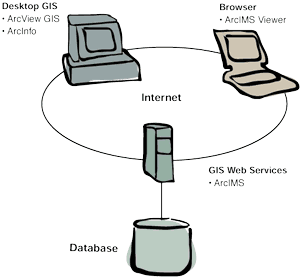 Any user with a conventional Internet Web browser can access the Geography Network. Desktop GIS software such as ArcInfo, ArcView GIS, and ArcExplorer can also access data and services in the same way that they work with local data.