|
|
||
|
|
|
|
|
|
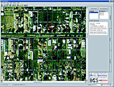
Based on MapObjectsGIS Application Inducted into SmithsonianA law enforcement software application built using MapObjects embeddable mapping components has been included in the Smithsonian Institute's 2000 Information Technology Innovation Collection. The collection, which was formally inducted into the Smithsonian's National Museum of American History on April 3, 2000, represents the year's most innovative applications of technology from 21 countries. William H. Gates, chairman and chief software architect of Microsoft Corporation, nominated the application for this honor.
MapObjects is used in conjunction with ShotSpotter from Trilon Technology, LLC, and Bradshaw Consulting Services, Inc. (BCS), as well as The Communicator! from Dialogic Communications Corporation (DCC), to form an innovative solution to reducing illicit gunfire in urban areas. According to Tony Bradshaw, BCS president, MapObjects basically acts as the link between ShotSpotter and The Communicator! ShotSpotter first detects gunfire by means of a set of specialized microphones strategically placed around high-crime areas. It then uses MapObjects to locate exactly where the shots were fired. MapObjects generates map and aerial photograph displays and provides law enforcement with the name, address, and phone number of the home or Business closest to the gunshot activity. This information is then used by The Communicator! to initiate a system of rapid notification to area residents. "MapObjects is the ideal tool for providing the mapping and identification capabilities that are essential to this application," says Bradshaw. For more information about this application, contact BCS President Tony Bradshaw at 803-641-0960. For more information about MapObjects, visit www.esri.com/mapobjects. |