|
|
||
|
|
|
|
|
|
GIS Helps Make Your Vote CountThe decennial census is required by the U.S. Constitution in order to determine the representation afforded each state in the U.S. House of Representatives. However, census data is used by government agencies and various other Businesses and organizations for the demographic data it provides. In particular, state and local governments, as well as many special interest groups, will use the Census 2000 data for political redistricting. By using Census 2000 data, legislatures in every state will redefine their voting districts so that each citizen is equally represented, thus ensuring that your vote counts.
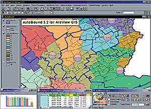
Redistricting NeedAccording to Bob Heath, a redistricting attorney with Bickerstaff, Heath, Smiley, Pollan, Kever, and McDaniel, L.L.P., "In 2001, jurisdictions all over the country will need to address the issue of redistricting." Bickerstaff, Heath, et al., is a Texas law firm that specializes in redistricting and voting rights litigation. The jurisdictions must first examine their old election districts and determine their population according to Census 2000 totals. If the population deviation between the largest and smallest districts is more than 10 percent, the jurisdiction should redistrict to prevent future litigation. In order for the one-person, one-vote Supreme Court decisions of the 1960s to be honored, legislative and other election districts are drawn with the goal of creating districts with equal population. Congressional districts in a state must be as close to equal population as possible. For other districts, such as legislative districts, city council districts, and school board trustee districts, a deviation of less than 10 percent is considered to be acceptable for creating balanced districts. Equal population is not the only criteria for acceptable district boundaries. Jurisdictions must also adhere to the guidelines set forth in the Voting Rights Act of 1965. The two sections that are most likely to hinder passage of a redistricting plan are Section 2 and Section 5. Under Section 2, any person who is a minority can sue by claiming their right to vote is being diluted or denied. Fracturing, or cracking, and packing are the two methods used for diluting a minority vote. To fracture a minority is to divide the group between several districts such that they cannot form a majority in any of the districts. In this way, the voting strength of the minority group is diminished. Packing involves creating a district that encompasses the entire minority group, instead of allowing them to have the majority in more than one district. Both cases are considered racially discriminatory and may be challenged in court.Section 5 only applies to certain jurisdictions and requires those states or localities to submit any changes to their election law to the U.S. Department of Justice before they can be enacted. Heath notes that redistricting has become even more complex "as new Supreme Court decisions are forcing governments to find just the right balance between recognition of traditional districting principles, such as compactness and contiguity, and preservation of minority voting strength." Performing this task has been an extremely time-consuming and expensive undertaking. Computer technology for redistricting was available after the 1990 Census, but it was very costly. Therefore, states spent large sums of money for redistricting applications, which were for the most part cumbersome. In most cases, special interest groups and local jurisdictions did not have the resources to afford the technology available at that time. Redistricting SolutionSince the round of redistricting after the 1990 Census, computer technology and GIS technology have improved at a fast rate. In 1990, most states needed to use minicomputers to handle the amount of data analyzed in the redistricting effort. Today, laptops may be used to perform redistricting tasks in a fraction of the time. In the realm of GIS, ArcView GIS has brought the leading GIS technology to the desktop. Redistricting attorneys such as Heath are using the latest in GIS technology to help their clients create districts that will hold up in court. Heath has chosen autoBound Intelligent Redistricting Software, developed by Digital Engineering Corporation, as his tool for redistricting. autoBound, an extension to ArcView GIS, allows him to examine several plans and view the impact of each. Sherry McCall, an autoBound user at Bickerstaff, Heath, et al., used autoBound in the final stages of a redistricting lawsuit case for the City of Houston. McCall stated that "autoBound early on would have been a tremendous benefit." autoBound provides the tools to take a jurisdiction from the first to the final steps of the redistricting process. First, autoBound offers a data administrator, which provides wizards for importing census data, such as TIGER files and PL 94-171 data, as well as non-Census data, such as election data. autoBound's enhanced manual editing tools allow a user to build districts using any level of census geography from census blocks to counties on countywide or statewide plans. The automated tool will create a district plan from scratch or will balance out the remaining districts of a partial plan created by the user. Finally, autoBound provides tools for exporting plans in a format required by the U.S. Census Bureau. In addition, plans may be exported to HTML format for viewing on the Web. A workspace manager is provided with autoBound to organize the plans within an organization. This tool catalogs the district plans created in autoBound and allows users to tag their plans as public or private. If a plan is made public by the user, others may view that plan using the workspace manager. AutoBound also provides an array of security features for accessing various plans and workspaces. Other tools include checks for contiguity, completeness, and compactness. BenefitsautoBound makes it easier for government to fulfill its obligation to create balanced voting districts so that each person's vote counts. Nevada, Washington, Arizona, Nebraska, and Virginia are just a few of the states that are using autoBound Intelligent Redistricting Software as part of the Census 2000 Redistricting Data Program. Because of autoBound's low cost, special interest groups and nonprofit organizations will also have the opportunity to be involved in the redistricting process. Redistricting is an excellent example of a GIS application helping the community. In addition, schools, police departments, local governments, and private Businesses use autoBound for redistricting applications. For more information, contact Monica Dombrowski, Digital Engineering Corporation, 5525 Twin Knolls Road, Suite 321, Columbia, Maryland 21045 (tel.: 410-772-0194, e-mail: fhejazi@digitalcorp.com, Web: www.digitalcorp.com). |