|
|
||
|
|
|
|
|
|
Police Department Crime Analysis Unit Improves Efficiency, CommunicationOverland Park, Kansas, Stays on Top with GISIn 1993, Overland Park, Kansas, reached some enviable goals—a low crime rate, good schools and hospitals, and sensible development. Those factors helped the City earn a top slot in the book, Fifty Fabulous Places to Raise a Family, on more than one occasion. That same year, the Overland Park Police Department established a crime analysis unit (CAU). Police Chief John Douglass says it was a move designed to streamline the department's efficiency, improve communications and dissemination of information, and help meet the high standards in crime prevention the City had come to enjoy.
The Crime Analysis Unit prepares maps for various officers or teams to support efforts to combat specific crime problem areas. The analysts in the CAU use Esri's ArcView GIS 3.1, ArcView Spatial Analyst, and ArcInfo to map crime data. Esri's software was a likely choice because the Overland Park Planning Department had been using ArcView GIS for several years. The GIS planning staff provided support to the newly formed CAU and also assisted in the development of several customized crime mapping applications. The CAU transfers data on a daily basis from Records Management (RMS), Computer-Aided Dispatch (CAD), and Field Interview Forms (FIFS) into the unit's FoxPro databases. Along with creating reports, bulletins, and responding to public requests, the unit uses the data to produce custom maps displaying both criminal and noncriminal information.
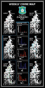
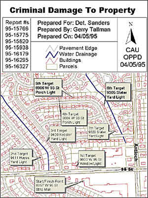
The Weekly Persons Crime Map is another map series showing robberies, purse snatches, rapes, window peepers, and lewd activity for the past 90 days. It also provides the home address of all registered sex offenders as well as the known sex offenders (those who have been arrested within the last 180 days for a sex offense) living in the City. The address of the incident and the name and physical description of the arrestee/suspect and suspect vehicle description are also provided. Because of its confidential content, this map is not released to the public and is only placed in secure locations within the department. The Viewable Daily Patrol Maps are an ArcView GIS application developed internally by GIS analysts that officers can access from several secured department computers. Officers can view and/or print out a map with details from the division level to individual patrol districts. Symbology on the map depicts the location of each target crime for the previous 48 hours. A report accompanies the map. An interactive crime mapping application, also developed internally, enables an officer, detective, or analyst to quickly and easily create a map of selected crime types (including modus operandi [MO] factors), areas, and date ranges. The CAU staff prepares Monthly Statistics Maps to show the locations of each month's residential, auto, and commercial burglaries, auto theft, robberies, and traffic accidents. They also prepare maps for their CAU Bulletins that typically concentrate on one single crime type or trend. During court testimony, detectives often use Court Prosecution Maps, which show crime scenes at a large scale. The CAU also prepares miscellaneous maps to support efforts to combat a specific crime or for noncriminal purposes such as redistricting and public safety meetings. The Monthly Traffic Safety Map is under development. It will show maps of fatalities, injury accidents, noninjury accidents, DUI arrests, traffic complaint areas, a list of top traffic accident locations, and a series of graphs with information about traffic accidents such as causal factors, day of week, and time of day. The CAU is in the process of purchasing The Communicator, an automated telephone notification system that will interface with the existing GIS data. This system will enable analysts to geographically select an area of the City, program a recorded message, and automatically call all residents and/or Businesses in that geographic area with information regarding crime patterns, trends, or notifications. This system will be shared with other city departments such as the fire department and public works. GIS has been a welcome resource to the Overland Park Police Department. It has been the primary tool in helping them provide timely, accurate, and useful crime analysis data. Overland Park is definitely on the right track—Fifty Fabulous Places to Raise a Family named Overland Park again in 1997 and various Washington, D.C., agencies have repeatedly placed Overland Park on the top 10 list of places to live, work, and raise a family. Ladies' Home Journal recently listed Overland Park as the second smartest city in the country, with 35.8 percent of its residents(25 years and older) having a four-year college degree. For more information, contact Gerald G. Tallman, manager, Crime Analysis Unit, at 913-327-6904, or e-mail: gtallman@opkansas.org. —Adapted from an article by Gerald G. Tallman, Susan Wernicke, and Jamie May of the Overland Park Police Department. |
 With a fast-growing population presently at 144,520, Overland Park is the third largest city in Kansas covering approximately 58 square miles and located in the Kansas City, Missouri, metropolitan area on the Kansas side of the State line. The police department employs 201 sworn officers and 75 civilians and is divided into two police patrol divisions consisting of 18 patrol districts. The CAU serves both patrol divisions, investigations, command staff, specialized units, governing body, and citizens. The CAU is staffed with four full-time employees and four citizen volunteers.