|
|
||
|
|
|
|
|
|
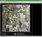
Updating Tax Maps in MississippiOutside the capital of Jackson, Mississippi, Rankin County is one of the top three fastest growing counties within the State. Since 1990, the County's population has grown from 80,000 to almost 110,000 people, spurring new housing developments, industrial sites, and other retail Business developments. Along with this expansion, the number of tax parcels has increased and now exceeds 60,000, requiring the County to launch new initiatives to meet Mississippi's 1997 Tax Commission regulations, stipulating that any county with more than 20,000 tax parcels must update its aerial photo inventory every 10 years. Like many growing counties, Rankin County's tax maps vary in their degree of geospatial accuracy. In this case, the County was using aerial photos taken in 1980 as a base for generating tax assessment information to the State. The deadline for the County to comply with the new State regulations was the spring of 2000. Getting StartedIn the spring of 1998, the County Tax Assessor initiated an extensive effort to update the aerial photo archive and create an up-to-date parcel map base that could be combined with existing vector data from the County's ArcInfo-based GIS and compatible with AutoCAD. The County hired consultant David Rankin from Pike County, Mississippi, to help them develop bid specifications for collecting aerial photography and rectifying the digital images. The County carefully considered many options for contracting the aerial imagery and finally determined that the necessary staffing levels and workload made the project well suited for outsourcing. The County received the first group of proposals from local photogrammetric services firms in December of 1998, but the proposed fees varied so widely that the County revised the specifications and issued a second Request for Proposal in January of 1999. The new proposals were evaluated for both qualifications and price and in February, the County selected GeoGraphix Inc., of Huntsville, Alabama, for the job. During the final stages of the selection process, the consultant along with representatives from the County and the State's Tax Commission Office made a visit to GeoGraphix to confirm their choice. "Our on-site visit confirmed that we had made the right choice in selecting GeoGraphix," said Barbara Collier, Rankin County's Tax Assessor. "We were impressed with their staff and working environment and were confident they could do the job." Following the site visit, the Rankin County Board of Supervisors approved the recommendation to award the contract to GeoGraphix. The aerial photography mission started immediately after the selection. An aerial photography crew, temporarily based in Memphis, Tennessee, captured the photos over the course of three days, carefully planning the mission during optimal weather conditions. The project included 30 flight lines and more than 2,600 aerial photos taken at a scale of 1"=1,000'. In May of 1999, GeoGraphix President Jorge Ferreira attended the American Society of Photogrammetry and Remote Sensing (ASPRS) conference in Portland, Oregon, where he viewed a demonstration of the newly released digital mapping software, IMAGINE OrthoBASE. By this time, GeoGraphix had already started Phase 2 of the project, the Pilot Area. Two of the County's map sheets were selected (one urban and one rural), and GeoGraphix rectified the imagery in these areas to the vector base using another software package. Following the demonstration of IMAGINE OrthoBASE, Ferreira decided that the software could help GeoGraphix produce a superior end product without raising the company's in-house production costs, primarily because of the software's capability to perform aerial triangulation on the fly.
"We needed to rectify the scanned aerial images and determine the accuracy of the anchor points in the existing vector data," said Ferreira. "Once I saw IMAGINE OrthoBASE, I was convinced that it would give us the accuracy we needed." GeoGraphix acquired IMAGINE OrthoBASE soon after ASPRS and went to work immediately to get trained and convert the project to the new software. ERDAS sent a trainer to Huntsville in June, allowing GeoGraphix enough time to master the new software and prepare for a proof-of-concept meeting scheduled with the County in July, during which the results of Phase 2 were to be analyzed. When officials from Rankin County arrived at GeoGraphix in July, they expected to analyze the first two sheets of the project and approve/disapprove the final County-wide production. Instead of seeing mismatched and warped data, however, they discovered that the final product would yield seamless and precisely edgematched coverage. GeoGraphix had also completed extra sheets around the preselected Phase 2 sheets to illustrate the advantages of the new process, clearly demonstrating the edgematching capability. "The edgematching and seamless coverage is what makes this project remarkable," said Ferreira. "IMAGINE OrthoBASE allowed us to deliver so much more to our client." The representatives of Rankin County and their consultant were very impressed with the results as well. "We were very pleased with what we saw at this first stage," said Collier. "It was clear that the ERDAS software enabled GeoGraphix to produce a far superior product than what we had expected." In January 2000, GeoGraphix completed the Rankin County tax map project. A total of 214 map sheets at 1"=400' scale, each containing four Public Land Survey sections, were delivered ahead of schedule and within budget. All of the digital map files are available for use in ArcInfo by the County's GIS users. How Did GeoGraphix Do It?GeoGraphix used a Vexcel VX4000 digital image scanner to scan the aerial imagery directly to ERDAS IMAGINE (.img) format for orthorectification. The final digital imagery had a ground pixel resolution of 1.0' and was registered to the AutoCAD vector tax base in 1"=400' sheets. USGS DEMs were used in conjunction with the control data provided by the County for linking to the existing ArcInfo GIS, resulting in an accurate geospatial database. Like most counties across the United States, Rankin County's digital database was compiled from a multitude of sources including tax parcels created by coordinate geometry from legal descriptions, road data digitized from rectified enlargements, and various data collected using GPS units. For this reason, the on-the-fly aerial triangulation capability of IMAGINE OrthoBASE was pivotal in the project's success (see "Achieving Ortho-accuracy in a GIS" for more information about aerial triangulation). Long Lasting BenefitsRankin County is now providing better service to its taxpayers by producing plots of any area, at any scale, with a digital image backdrop. The one-foot pixel resolution allows the Mapping Department to clearly plot up to 1"=100'scale anywhere within the County, which will be helpful to the County's appraisers as they conduct physical inventory of parcels. But there are other rewards that the County is realizing as well. Consider the County's E-911 road maps. They were derived from topographical quadrangle maps then augmented with heads-up drawings and GPS data, making it difficult to "guess" which data was good and accurate and which vector data was "off." IMAGINE OrthoBASE's aerial triangulation residuals allowed GeoGraphix to analyze several large areas, pinpoint the trouble spots, and identify which data were the most accurate. The residuals also provided GeoGraphix the means to choose accurate ground control points and helped to direct the County to the data most in need of updating and rectification to the new digital image map, which eliminated the guesswork and increased the accuracy of the results. "The new map not only helps us to accurately assess improvements among parcels," said Collier, "but we can also identify high growth areas and, if necessary in the next two to five years, focus on a particular area that might need updating without having to fly the entire County. This will save us thousands of dollars and thousands of hours." The success of the project has spread across the State, spurring other counties to turn to Rankin County for advice on how they can cost effectively update their digital map base. For more information, contact Sally Rochelle, Certified Photogrammetrist with GeoGraphix and Rankin County project manager (tel.: 256-721-0706, e-mail: sally@geographix-inc.com). |