
ArcGIS Data Models—Standards for Implementation and Data Sharing
Esri has been working with more than a dozen user communities to develop a series of ArcGIS data models. The purpose of these data model projects is to create standard "templates" and documentation for how a series of generic geographic data types should be modeled in a geodatabase. This will:
- Facilitate interoperability of data sets between users.
- Simplify GIS system implementation.
- Simplify GIS data sharing.
- Create agreement for how data can bemodeled.
As we continue to share and make our data more available via networks, we will need more standardized data models for facilitating 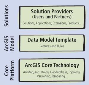 interoperability and providing ways of accessing data. This will require a need for consistency between data sets within organizations and for society as a whole.
In each discipline/industry, Esri has been facilitating the participation of industry experts, end users, Business partners, and academic leadership. The purpose is to assist these groups in the development of a data model for their particular field. The focus is on developing an "essential" data model (e.g., the common data model that meets the basic need of both producers and consumers of the GIS data).
The design participants have gone through practical, hands-on exercises that build on industry standards, successful project team experience, and technical knowledge of the geodatabase to develop a template for the ArcGIS platform.
"The templates are typically a great starting point for project teams, a way to simplify project implementation by capitalizing on existing industry knowledge," according to Steve Grisé, ArcGIS data model product manager. "The support from each industry has been outstanding. A special thanks to everyone who has been involved for your continued support and teamwork."
The data models are also a great starting point for Esri Business partners who are building applications and solutions—they can get started faster, and users quickly understand the value of the applications that are being built on a combination of the data models and the ArcGIS platform. Overall, there are many benefits to the data models, but their primary value continues to be a way for people to start with more than a blank sheet of paper at the beginning of their project.
Planned data model initiatives include the following:
- Administrative Boundaries/Census
- Basemap
- Biodiversity/Conservation
- Defense
- Energy Utilities
- Environmental Regulated Facilities
- Forestry
- Land Parcels
- Petroleum
- Telecommunications
- Transportation
- Water Utilities
- Water Resources (Hydro)
For more information, contact Steve Grisé, Esri (tel.: 909-793-2853, ext. 1-2494; e-mail: sgrise@esri.com).