
ArcView 8.1 Now Shipping
ArcGIS 8.1: A Single, Integrated GIS
ArcGIS is a family of software products that form a complete GIS built on industry standards that provide exceptional, yet easy-to-use, capabilities right out of the box. 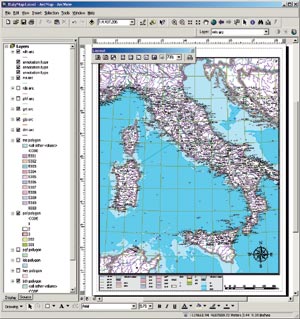 This release features a common architecture, common code base, common extension model, and a single development environment for ArcView and ArcInfo.
At right: Enhanced cartographic tools are some of the key features in the ArcGIS Desktop products (ArcView 8.1, ArcEditor 8.1, and ArcInfo 8.1). Data courtesy of the National Geographic Society.
ArcView 8.1, ArcEditor 8.1, and ArcInfo 8.1 share a common interface. This shared interface along with shared architecture make ArcGIS and geographic information accessible to a host of users with various GIS needs. The common architecture also allows users to share scripts, custom tools, applications, and extensions. The release of ArcGIS 8.1 makes the geographic information system and its tools accessible to virtually everyone within an organization. The ArcGIS 8.1 release consists of ArcView, ArcEditor, ArcInfo, ArcSDE, and six new ArcGIS extensions (see "ArcGIS Extensions for ArcView 8.1").
ArcView 8.1 Built with Exciting New Architecture and User Environment
ArcView 8.1, the most significant release in the history of ArcView, is now shipping. Esri has built ArcView 8.1 with a completely new architecture and user environment  based on current standards in the information technology (IT) arena. ArcView 8.1 features an intuitive Windows user interface and includes Visual Basic Applications (VBA) for customization.
ArcView 8.1 maintains the base functionality of ArcView 3.x and adds a host of improvements driven by user requests. New features include a catalog for browsing and managing data, on-the-fly coordinate and datum projection, metadata creation, new editor tools, support for static annotation, enhanced cartographic tools, direct access to Internet data, and much more.
Above and below: The ArcGIS Desktop products provide advanced visualization tools including an optional extension for three-dimensional analysis.
ArcView 8.1 is an exceptional stand-alone GIS as well as the entry point to ArcGIS, an integrated and scalable family of GIS software products. ArcGIS consists of ArcView, 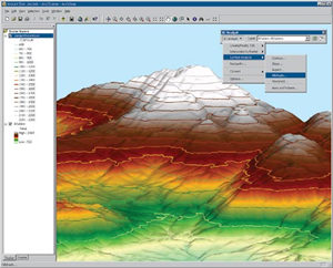 ArcEditor, ArcInfo, and ArcSDE. ArcGIS extends ArcView by providing multiuser editing, advanced analysis, Internet services, and high-performance spatial database services.
For more information, visit www.esri.com/arcgis or www.esri.com/arcview or call Esri at 1-800-447-9778. To order ArcGIS 8.1 or ArcView 8.1 in the United States, call Esri at 1-800-447-9778, call your Esri regional office, or contact your local reseller. Outside the United States, please contact your local Esri distributor.