
Czech Republic Produces Military Maps According to NATO Standards
Czechoslovakia's "Velvet Revolution" in November of 1989 set the stage for a democratically elected government later that year, followed by the peaceful division of Czechoslovakia into the Czech Republic and Slovakia in 1993.
The Czech Republic then began to prepare for membership in the North Atlantic Treaty Organization (NATO). One of the requirements was the standardization of military geodesy  and cartography products required for strategic planning and geographic support of both national forces and NATO alliance peacekeeping operations.
Right: MTI has 72 ArcInfo seats, which they use for data collection, maintenance, and analysis.
According to Captain Lubo Reimann of the Military Topographic Institute (MTI) of the Army of the Czech Republic, the military decided at that time to take advantage of the necessity to remap the Czech Republic by implementing a digital system rather than continue with their existing traditional mapping methods.
"The MTI is part of the government's topographic service and is responsible for the creation, collection, and maintenance of all geographically related information for military use," comments Reimann.
Adhering to NATO's Digital Geographic Information Exchange Standard (DIGEST) to facilitate data exchange among different military groups, including planning, management, and weapon systems, the MTI digitized more than 1,000 map sheets at a scale of 1:25,000. Previous military maps were used as the primary data source, and orthorectified aerial photography images are now used as a backdrop to expedite basemap 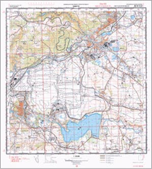 development. Fieldwork is necessary to establish such things as specific land use, building type, and the heights of various manmade and natural features.
Left: MTI produces a number of products including some special maps derived from aerial images and are commonly used to map airports, military training bases, and other strategic facilities.
The resulting project is DMU25, a vector database with the same spatial precision as the military topographic maps at a scale of 1:25,000. The graphic information is stored in 20 coverages. When complete, its extent will be more than 70,000 square kilometers. A recent application concerns the creation of topographic maps in user-defined projections, symbolizations, and scales ranging from 1:10,000-25,000 to 1:25,000-100,000.
MTI has 72 ArcInfo seats, which they use for data collection, maintenance, and analysis. Specialists at MTI developed their primary production technology using ArcInfo software tools. ArcView is used throughout the agency for data viewing purposes.
MTI used Esri's Production Line Tool Set (PLTS) software programs to help standardize its GIS development. PLTS tools produce standard National Imagery and Mapping Agency (NIMA) products such as digital data in Vector Product Format (VPF). MTI produced VMap 1 data from the territory of the Czech Republic and two other geographic data libraries, as well as printed military topographic maps and nautical charts that meet NIMA specifications.
"The Czech Military Topographical Survey originally signed an agreement in 1990 with America's Defense Mapping Agency (DMA), the organization that preceded NIMA. This was the first agreement between the U.S. and Czech militaries," observed Reimann.
Attributes are extensive in the MTI database, which includes more than 300 distinct features that are categorized into roads, railways, bridges, boundaries, populated places, drainage, relief, vegetation, and miscellaneous. This promotes its use by civilian authorities in times of national emergency such as the catastrophic flooding of the Moravia River in 1997.
MTI is making efforts to develop cooperative relationships with civilian mapping agencies within the Czech Republic and has allowed the West Bohemian electric facility to make use of its comprehensive database in developing its own GIS. The electric company has promised that it will offer its data to the MTI when it has completed work 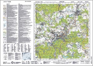 on developing its database for high voltage electricity, which will be very useful to the agency.
MTI produces a number of products including some special maps such as satellite training maps at a scale of 1:50,000 and 1:250,000, cross-country mobility maps at a scale of 1:100,000, Position Information Graphics (PIG) at a scale of 1:50,000, and photomaps at a scale of 1:10,000. They are derived from aerial images and are commonly used in the mapping of airports, military training bases, and other strategic facilities. They can also be used for a variety of other applications including agriculture, forestry, ecology, civil engineering, regional land management, terrain analysis, and so on.
In the near future, MTI plans to put all of its topographic data into a single database. This will not only allow the performance of global GIS tasks, but it will also facilitate the creation of maps that have coordinate systems different from the original topographic maps to allow better coordination with the Czech Republic's NATO partners.
Concludes Reimann, "I believe that the future of GIS use at MTI is in putting our data on a military Intranet to allow greater use of the information throughout our agency and to perform faster transactions from the database. Use of products such as Esri's ArcGIS, ArcSDE, and ArcIMS is the direction that we will be moving as we upgrade our software."
For more information, contact Petr Seidl (e-mail: petrs@arcdata.cz).