
European Geological Survey Organizations Focus on GIS Initiatives
There are more than 40 individual nations in greater Europe, most smaller than the average state in the United States. Each of these countries has a geological survey 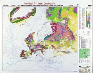 organization (GSO) and every one produces high-quality geological maps and related geoscience data, often at scales as detailed as 1:10,000. This is a high-resolution, spatially related knowledge base with a pedigree of more than 150 years! Yet so few outside the geological profession seem to be aware of its availability and the relevance of this immense, comprehensive, and unique but underexploited resource.
Above right: A Geological GIS Under Construction: When it is complete, the IGME 5000 GIS will hold geological map information for the whole of Europe.
Today's decision makers, the politicians, financiers, Businessmen, legal professionals, and those in the geoinformation Business who support them, are often woefully unaware of the critical role geological factors play in disaster mitigation and planning, environmental protection, and sustainable resource development. The importance of geology to human health, the environment, property, and assets is grossly underestimated. The failure to take it into account leads to increased financial costs (e.g., poorly designed construction schemes), reduction in the quality of life of citizens (e.g., radon emission and polluted water supplies), and at worse, loss of life (e.g., due to earthquakes and landslides).
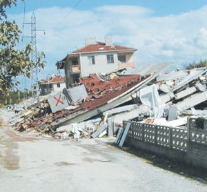 Left: Damage in the Gölchuk region of Turkey from the Kocaeli earthquake of August 17, 1999. BGS staff were involved in the post-earthquake damage survey. (Photo: Russ Evans, BGA © NERC).
To some extent, the GSOs themselves accept responsibility for the failure of potential users to exploit their knowledge base. After all, for many years the traditional output of their work has been complex, technical, and academic paper geological maps and reports. The quality of their science was never in question but the relevance of their output to our society and environment was not obvious to the public, governments, and commerce.
However, over the last 20 years many European GSOs have been trying to address that shortcoming and meet user needs with a whole range of applied and thematic products, many of them driven by the users themselves. The more advanced GSOs started to apply CAD and RDBMS software in the 1980s, and the majority are now using Esri GIS and mapping technology to create maps and customized products for a whole range of clients.
A Harmonized and Searchable Database
In 1997, 15 GSOs (operating through EuroGeoSurveys, their umbrella association based in Brussels) were successful in obtaining European Community (EC) funding for a proposal to construct a harmonized and searchable database of geoscience information as far as the metadata level. The aim was to exploit GIS and the Internet to advertise and improve 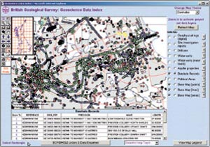 the visibility and accessibility of their information bases. The proposed system, the Geological Electronic Information eXchange System (GEIXS), was to be implemented on a Web server, creating a one-stop-shop access point to 15 disparate national data sources (geixs.brgm.fr). The bid to the EC argued the difficulty of approaching each national survey separately to determine what pertinent information existed, especially as each utilized different standards, formats, and languages. It also stressed the point that geology and its associated problems do not respect national borders.
Above right: A screenshot from an iGDI session displaying borehole information held by BGS in the Newcastle-upon-Tyne area, United Kingdom.
The metadata within GEIXS is spatially referenced, and in addition to text retrieval, a graphical user interface (innovative at the time) was developed. The database is also linked to a multilingual thesaurus so that it can be interrogated using 12 European languages.
GEIXS was extended in December 1998 to include eight central European nations and Norway, and the EC contract was completed successfully in December 1999. Perhaps one of the more understated but fundamental achievements of the project is that it galvanized 24 independent geological survey organizations to pool expertise and resources and work toward a common goal! The GEIXS system continues to be managed and maintained by the EuroGeoSurveys association. The virtues of the concept remain, but, as one might expect of an information system whose initial development started more than four years ago, its implementation is now in need of an overhaul. A major upgrade is therefore currently underway; the centralized database model, appropriate four years ago when few GSOs had the capability to organize their metadata, has proved increasingly difficult to maintain and will be replaced by a distributed system accessed via a single portal. The hardware and software platform will be upgraded, taking full advantage of Web-enabled GIS technology to ensure that the unique and invaluable geological survey knowledge bases continue to be visible and accessible.
High-level data catalogs like GEIXS have a crucial role to play, but GSOs now have the bit between their teeth and, both collectively and individually, are exploiting GIS technology to make more detailed information available across a whole range of geoscience disciplines. Following are some descriptions of only a few of these services and initiatives.
An International Geological Jigsaw Puzzle
An ambitious GIS project, the 1:5 million International Geological Map of Europe and Adjacent Areas (IGME 5000), is being managed and implemented by the German Federal Institute for Geosciences and Natural Resources under the aegis of the Commission of the Geological Map of the World (CGMW). The project now involves more than 50 European and adjacent countries and the final area covered will reach from the Caspian Sea in the east to the Mid-Ocean Ridge in the west, and from Svalbard in the north to the southern shore of the Mediterranean Sea. The project is developing a GIS underpinned by a geological database, from which standard and customized geological and thematic maps providing up-to-date and consistent information will be produced. The GIS will hold significantly more information than the previous printed maps could ever provide. It will also offer versatility, for example, the ability to retrieve and present for the whole of Europe information on rock age, composition, and structural and metamorphic features.
More importantly, the IGME 5000 GIS will provide the essential foundation for pan-European applied geological/thematic mapping. The project platform is ArcInfo 8, ubiquitous in GSOs across Europe. However, the ultimate intention is to make the IGME 5000 GIS available on the Internet using Web-based mapping software. To deliver harmonized geological information across Europe in digital form, even at such a low resolution, requires exacting and extensive pan-national standards that simply did not exist and thus, in many respects, the IGME 5000 project is acting as a vehicle to initiate such standards in Europe. While previous paper geological maps have, and will, tolerate inconsistency between map sheets, GIS and related digital systems need a much more stringent approach. The goals of interoperability and data integration, of obtaining the optimum benefit from information technology, and the ability to share and supply harmonious information for scientific research to address pan-national geological problems across frontiers are entirely dependent on the continuity and consistency that these standards will bring.
For more information, contact Kristine Asch (e-mail: K.Asch@bgr.de, Web: www.bgr.de/karten/IGME5000).
Climate Control Through Applications of Carbon Dioxide Storage
Following the 1997 Kyoto, Japan, climate conference, a consortium of eight European GSOs launched a project for 2000, spanning three years, that studies the technical and economical feasibility of wide-scale application of carbon dioxide (CO2) storage in the subsurface. This project (named GESTCO) will undertake research into whether sufficient geological storage capacity is available for specific emission sources within selected key areas in Europe. Surveys of these key areas will result in a GIS database describing CO2 sources (e.g., power plants and industrial emitters), potential geological storage 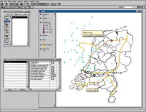 locations (e.g., aquifers, depleted oil and gas fields, geothermal reservoirs, coal and salt mines), and already existing transport infrastructure (e.g., pipeline systems). As part of the project the Netherlands Institute of Applied Geoscience TNO, one of the GESTCO participants, will develop a decision-support system (DSS) (currently in design stage) that calculates costs and economic risks of realistic combinations of CO2 emission sources, transport possibilities, and storage capacities for each of the selected areas.
Above left: This image shows a prototype GESTCO DSS.
The DSS will be founded on ArcView GIS extended with ArcView Spatial Analyst. The end user interfaces with ArcView GIS and defines a removal scenario by selecting CO2 sources, a storage location (e.g., sink) and, optionally, pipelines. After scenario composition, ArcView Spatial Analyst will determine the least costly transport route in case the scenario demands new and/or additional pipeline(s). For this, ArcView GIS is fed with data that expresses costs related to pipeline construction and costs determined by aspects such as land use, elevation, artificial, and natural barriers. Existing pipeline corridors can be added in grid format so that ArcView Spatial Analyst can take these into account when searching for the optimal route. Once the scenario is completed with an optimal routing between sources and sink, calculation models will kick in and evaluate remaining technical and economical aspects of the problem definition.
The cost for CO2 separation at the source is calculated and the size of the CO2 flow in time from source(s) to sink is used to calculate the needed dimensions of pipelines and the number of compression stations along the route. Storage models will evaluate the chosen sink on volumetrics (e.g., pore volume, compressibility, and sweep efficiency) and injectivity behavior (e.g., fluid mobility, injection rate, and number of needed wells). These calculation models will be implemented outside ArcView GIS and coupled as dynamic link libraries. When all calculations are finished, the results are gathered within ArcView GIS and the whole scenario evaluation will be presented to the end user in numbers and graphs and, of course, the chosen route is geographically mapped. The end user will get an answer on whether it is technically possible to separate, transport, and store an amount of CO2 over time and how much such a scenario will cost.
For more information on the GESTCO project, visit www.nitg.tno.nl/projects/eurogeosurveys/projects/Gestcoweb or contact Frank Keppel (e-mail: f.keppel@nitg.tno.nl).
Harnessing the Web
Individual European GSOs are now incredibly active in harnessing the Web in a whole range of innovative ways. The British Geological Survey (BGS) was among the first to exploit Web-enabled GIS, using ArcIMS to provide comprehensive access to all its data sets. In line with United Kingdom (UK) government policies on open government and e-science, BGS has been working hard to make more and more of its information available to the general public and professional clients. The Internet Geoscience Data Index (GDI) (www.bgs.ac.uk/geoindex) allows users to access a comprehensive set of geoscience information online. Against Ordnance Survey topographic backdrops, users can search the UK territory, onshore and offshore, for borehole records, geochemical sample sites, geophysical surveys, hydrogeological observations, and much more. 1:625,000-scale geological maps are available online, as are false-color satellite images, which provide a dramatic view of the UK landscape.
BGS has also worked in partnership with Esri (UK) Ltd. to develop a comprehensive, Web-enabled GIS to provide an oil and gas exploration and production data service for Common Data Access Limited (CDA). The system, known as Digital Energy Atlas and Library (DEAL), is a concept promoted by the UK Offshore Oil Operators Association (UKOOA) who are the owners of CDA. The aim is to increase the competitiveness and efficiency of the UK hydrocarbon industry. The DEAL database is intended to become the single virtual repository for UK data. Users will be able to select data and be directed to the data vendor Web site or e-mail contact. DEAL went live in September 2000 and may be accessed at www.ukdeal.co.uk.
For more information, contact Ian Jackson, British Geological Survey, Nottingham, United Kingdom (e-mail: ij@bgs.ac.uk, tel.: 44-115-936-3214, fax: 44-115-936-3269, Web: www.bgs.ac.uk).
Going Strong Since 1850
Founded in 1850, the Bavarian Geological Survey is among the oldest institutions of its kind and is responsible for the collection, evaluation, and dissemination of geoscientific data for the state of Bavaria. The survey implemented Esri's ArcInfo in 1991, and today, nearly every department uses GIS as a standard tool for data analysis and thematic map production. The staff uses 15 ArcInfo licenses with ARC TIN and ARC GRID, ArcPress, and 40 ArcView licenses with ArcView Spatial Analyst and ArcView 3D Analyst extensions. For more about the Bavarian Geological Survey, see "Mapping an Ancient Meteorite Crater Gives Scientists Insight About Future Risks".
These are just a few of Europe's GIS-based initiatives. To explore the others, visit EuroGeoSurvey's www.eurogeosurveys.org/index.html.