
Israel Civil Aviation Authority Flies with Permit Tracking System
The Israel Civil Aviation Authority (ICAA) has stringent air safety requirements, making construction at or near airports and related facilities highly regulated. To expedite the construction permit approval process, the ICAA decided to implement a GIS-based solution. The GIS is called the "Yahav" system and has eliminated 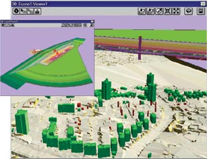 key bottlenecks in the approval process. Yahav is a Hebrew abbreviation for the building restriction department.
To accomplish this, the ICAA approached Advanced Geographic Information Systems Ltd. (AGIS) of Tel Aviv and asked the company to develop a GIS-based building permit and town plans tracking system that complies with International Civil Aviation Organization (ICAO) regulations.
Right: Both of these images are three-dimensional displays of height restrictions around an airport runway on the datum plan of the City of Eilat.
As an initial step, documents required by the applicants were redesigned so they could be integrated into the GIS to help automate the approval process and then georeferenced to the database to be used for review and analysis purposes. An application was then developed that determines whether or not a submitted town plan or building permit application complies with established height limitations and other restrictions.
Restriction boundaries contained in the database include height restrictions, noise limitations, and avian zones. The main inspection module of the GIS includes the ICAA compliance categories related to each restriction and their zones and subzones. This allows a quick analysis of a submitted building permit and indicates whether or not approval will be forthcoming. If not, the system indicates what needs to be modified in order to obtain approval. It also filters all construction requests submitted to the local planning committee and sends those that fall within airport boundaries to the ICAA for approval.
The module keeps track of all events during the approval process for review and archival purposes. When an applicant fulfills all of the requirements to submit an 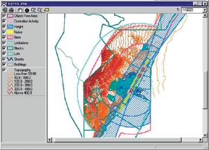 application for a building permit, the system automatically compares the submitted application with the existing restrictions or conditions for the permit approval. The system also issues forms to be approved by parallel departments that deal with flight safety, flight control, airport management, and the airport operations center. Responses are entered into the system and monitored according to the timetable allocated for the approval/disapproval of a permit.
Above left: A two-dimensional geo-inspection screen.
The Yahav system includes MapObjects, ArcView GIS, and ArcView 3D Analyst software. The GIS gives the ICAA a three-dimensional visualization of the airport and any significant obstructions. A spatial algorithm was developed to compute both the three-dimensional height zone restriction and earth surface to enable immediate spatial intersection results.
A successful pilot study was recently completed at Eilat airport, which lies in the southern part of Israel. There, the simulated geometric plane of a landing aircraft and related restriction zones are intersected by the existing mountainous terrain, which made use of the Yahav system essential. Following this 18-month pilot project, implementation began at six major civilian airports with the remaining airports in Israel to follow.
Comments Doron Cohen, managing director of AGIS, "The ICAA is very happy with the effectiveness of the Yahav system. They have even asked us to extend the functionality of the GIS to include more administrative procedures."
In the future, the Yahav system will create on-the-fly obstacle maps and transmit them to onboard flight computers as soon as an airplane enters the control tower domain to increase flight safety.
For more information, please contact D. Cohen (e-mail: agis@netvision.net.il).