
USGS Powers Planetary Science Research Site with ArcView IMS and ArcIMS
Mars Research Supported by Online GIS
In 2003, when two Mars Exploration Rovers (MER A and B) take off for the red planet, their Martian itinerary will have been mapped out with the help of GIS. Landing in 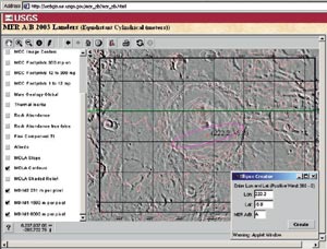 different regions of the planet, each robotic explorer will carry a sophisticated set of instruments and a sampling tool designed to assist in their major mission—to find evidence of water.
Right: The customized ArcView IMS MER 2003 interface is shown. The layers visible are the Mars Digital Image Mosaic 2, elevation contours, and MOC footprints. The client generated the ellipse using the applet window show on the right.
In preparation for this and other planetary research, the U.S. Geological Survey (USGS) Astro-geology team in Flagstaff, Arizona, is providing a Planetary Interactive GIS-on-the-Web Analyzable Database (PIGWAD) for the entire science community to use (webgis.wr.usgs.gov). The Planetary Geology and Geophysics Program of the National Aeronautics and Space Administration (NASA) supports this USGS endeavor under the auspices of the Planetary Cartography and Geologic Mapping Working Group (PCGMWG) and the Mars Exploration Rover mission.
Powered by Esri's ArcView Internet Map Server (IMS) and ArcIMS, PIGWAD is bringing together Viking and Mars Global Surveyor (MGS) orbital mission data sets to help researchers address issues such as Martian channel formation, surface ages based on impact crater densities, and overall geologic makeup. More recently, with the addition of information including engineering constraints on where to land MER A and B, the database is playing an important role in premission phases to assess feasibility and safety of potential landing sites and to plan objectives.
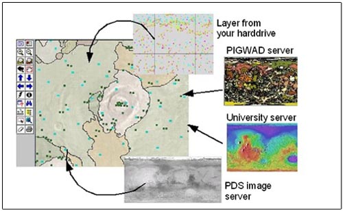
A diagram depicting how in the near future a researcher can build a multilayered planetary database from multiple GIS Internet services residing at different locations.
USGS scientists in Flagstaff and Trent Hare, a USGS GIS and computer specialist, are now focusing on creating a Web-based landing site analysis page for the Mars Exploration Rovers. "We are working on getting all of the data GIS-capable so that it is research ready," says Hare. The data keeps coming. "We already have gigs and gigs of data, but Mars Global Surveyor continues to send us more—and not just imagery. MGS is also sending thermal spectroscopy [used for mineral analysis] and billions of elevation point data." And with the Mars Odyssey orbiter to arrive at Mars in October of this year, the data volume will continue to grow.
Flexibility the Key
The use of GIS technology in planetary research has been explosive because of its flexibility in data management, time and cost efficiency, ease of updates, and one of its most important strengths—the ability to produce multilayered databases for comparison studies.
This layering capability is helping tremendously with the landing site selection. Even with restricting the landing site to the middle latitudes of Mars, according to Hare, taking all of the variables into account can be overwhelming. "Just looking at the engineering constraints, you have to make sure that the surface albedo is not too bright, because that indicates there's too much dust. The rover could possibly sink too far into the dust. And we have to make sure that the parachute has enough time to slow down the descent vehicle on entry. Otherwise, if you choose a site with a high elevation, you're going to hit the ground before you slow down enough. There are so many variables. We want to pick an area that's interesting but safe," says Hare.
Asking Informed Questions
The PIGWAD site offers researchers working on the landing site selection a landing site ellipse generator, which gathers statistical information about a site's rock abundance, elevation, slope, morphological descriptions, and other data that an optimally safe and scientifically interesting landing site requires.
The ArcIMS interface gives users the ability to view any combination of data sets and performs complex queries. Its image-streaming capability streams small, compressed 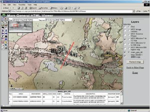 snapshots (points, lines, or polygons) of selected map layers. The PIGWAD site also offers many of its online layers in a vector format that can be used with a Java interface; ArcExplorer; or the new ArcView 8.1, ArcEditor 8.1, and ArcInfo 8.1 software. After the features are downloaded to the user's computer, the response rate is faster because the interface does not ask the server for every map. This also enables users to change how a layer is drawn. Researchers also have the option to download data from PIGWAD and incorporate that with data from other locations to create and query their own unique maps.
Above left: The layers visible are the Mars Digital Image Mosaic 1 global geologic map, and MOC narrow angle footprints. The red line, drawn by the user, selected the intersected geologic units listed in the bottom frame.
Selecting a landing site and sampling the soil from it will be a few more steps in the direction of trying to answer the question that nobody is sure of—whether there was or is water on Mars. "You definitely don't want to choose sides yet," says Hare. "We don't want to say that there's definitely lots of water on Mars. And we need to ask what form it may be in? Is it simply liquid water, or is it charged with CO2, or are all the river-channel-looking features created from glaciers or catastrophic debris flows? Having these new data sets has been phenomenal. It just opens up more doors."
Answering the water on Mars questions will help scientists determine if a human mission to Mars would be possible and will also give them a basis for understanding the evolution of geology and climate and whether life ever arose.
There Are No Limits
Most of the databases at PIGWAD are Martian but there is one Venus site. Hare is also hoping to support several lunar data sets by the end of the year. The Martian sites contain the Viking digital image mosaics, Viking image- and stereo-resolution maps, 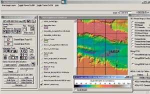 geologic maps, Mars Orbiter Laser Altimeter (MOLA) tracks, MOLA topography, MOLA shaded relief, Mars Orbiter Camera (MOC) footprints and image centers, and Viking Infrared Thermal Mapper data.
Right: The MER 2003 ArcView Data Publisher is shown, with the Interface on the left showing some of the unique tools built for this product. The layers shown include a MOLA shaded relief and a priority landing site in the Valles Marineris region of Mars. The window on the right displays more image layers that can be added.
Space exploration research is ongoing. "For every researcher using these data sets, there are probably just as many people in the education system using the data," says Hare. "We're seeing a nice trend now with college students graduating with a GIS background. And so a lot of people are starting to get on the bandwagon and make sure when they generate a data set, others will be able to bring them into a GIS and use them."
In addition to the MER Web page, Hare has also produced a CD-ROM to help scientists find a safe place to land the rovers. For more information about PIGWAD, visit webgis.wr.usgs.gov or contact the USGS (tel.: 520-556-7126, e-mail: thare@usgs.gov).