
MapObjects 2.1 Is Now Available
The newest version of Esri's powerful set of embeddable mapping and GIS components is now available. MapObjects 2.1 offers many new features including support for 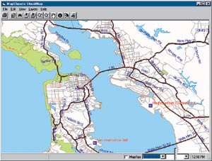 AutoCAD 2000 DWG files, ActiveX Data Objects (ADO), image catalogs, ArcSDE 8.1 support, a projection engine update, ArcView StreetMap 1.1 for geocoding, custom symbols for chart rendering, and a new run-time deployment utility for easier application distribution.
Right: MapObjects 2.1 supports ArcView StreetMap 1.1 for geocoding.
MapObjects 2.1 can also read ArcSDE versioned layers; it can connect to any ArcSDE version and allow users to view it. Users can also identify and select versions based on version names.
To help users develop Web-based mapping and GIS applications, MapObjects 2.1 has built-in compatibility with Esri's ArcIMS Web connectivity middleware. This means you can use MapObjects to put dynamic, customizable maps on the Internet via the latest ArcIMS technology.
According to Victoria Kouyoumjian, Esri's MapObjects product manager, "With these new capabilities, we've extended the functionality of the product to allow developers to design their most effective embeddable mapping application and redistribute it easier than ever before."
MapObjects users who acquired a license for version 2 on or after March 1, 2001, will receive a free upgrade to version 2.1.
For more information, visit www.esri.com/mapobjects or call Esri at 1-800-447-9778, call your Esri regional office, or contact your local reseller. Outside the United States, please contact your local Esri distributor. MapObjects can also be purchased online from Esri's GIS Store at http://store.esri.com.