
The Study of Kerkenes—GIS Innovations in Central Turkey
Simulation and Dynamics of an Ancient City
By Geoffrey D. Summers, Middle East Technical University, Ankara, TurkeyThe City of Kerkenes, on the Kerkenes Mountain in central Turkey, was constructed around 600 B.C., in the middle of the Iron Age. It was, for a brief period, the largest and one of the most important cities on the high plateau of Anatolia. Kerkenes would 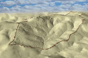 have been subject to many of the problems familiar to modern urban life: bustle, noise, foul air, and congestion. It would have been a thriving, dynamic place, crowded with horses, mules, donkeys, camels, carts, and barrows. The porticoes would have echoed with the calls of vendors and animal drivers and with the shouts and groans of laborers and builders. The streets and drains would have swarmed with flies. Then around 547 B.C., Kerkenes was sacked and put to the torch by Croesus, king of Lydia and the richest man of the ancient world. Today, the remains of the City lie inches below the surface—mute witness to a long forgotten civilization.
Above right: Simulation of the Iron Age city at Kerkenes in central Turkey: The GPS data was processed in ArcView 3D Analyst and exported to Photoshop for final image production.
Though long gone, Kerkenes can now be re-created, analyzed, and brought to life in ways that reach out to modern-day students and the public alike. Modern technologies have provided archaeologists with the ability to recover the plan of this City, with its laid out streets and public spaces, its springs and reservoirs, its public buildings, and its urban blocks—all within a 7 km circuit of colossal stone defenses. In its heyday, caravans of camels would have traveled between Kerkenes and Mesopotamia and Iran. Fuel and food would have been constantly brought into the City, soldiers would have trained, weapons would have been manufactured and repaired, new buildings would have been erected, and children would have shrieked in the streets.
GIS provides powerful tools that are allowing archaeologists to create virtual simulations of the remains as they survive today and holds the potential for making virtual reconstructions of the City as it once was. Kerkenes, because it had such a short life and because almost the entire plan is recoverable in remarkable detail, provides a laboratory for experimentation with and development of these new tools. The Kerkenes Project has created a database that descends from high-level aerial photography with a manned hot air balloon through detailed low-level photography from a blimp to precise simulation of the ground surface using kinematic GPS.
Between 1997 and 2000, Scott Branting of Chicago University, assisted by Nurdan Atalan of Hacettepe University and K�ksal Sanli of Middle 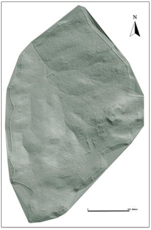 East Technical University, conducted a GPS survey over the entire area of the City. An enormous 1,400,000 GPS readings were processed in ArcView 3D Analyst to produce triangulated irregular network (TIN) images. Modern survey techniques also enable us to discover what is below the ground surface and to do so without resorting to the destructive, expensive, and intensive methods of excavation that are the mainstay of traditional archaeology. Magnetic maps, made with Geoscan fluxgate gradiometers, depict not only walls and buildings but can even reveal the position and size of doorways. It is thus possible to descend, in a manner of speaking, below the surface of the ground.
Above left: A TIN simulation of Kerkenes made in ArcView 3D Analyst from 1,400,000 collected GPS readings.
The result is a series of maps made by combining the two-dimensional images from aerial photography and geomagnetic mapping with three-dimensional GPS models. From these maps it will be possible to use CAD programs to make architectural reconstruction of buildings and to use imaging programs to render these reconstructions in realistic ways. Designers, city planners, and architects routinely use this arsenal of techniques to visualize and display their designs. The demands of the Kerkenes Project, however, pose particular problems. The database is huge and the level of detail very high. Attempts are being made at creating accurate representations of real structures based on the exact position of their foundations. All of these issues are, of course, primarily graphical. Images are combined, interpreted, reconstructed, rendered, and displayed.
The potential of GIS for archaeology is not, however, merely graphical. The great importance of GIS for the study of ancient cities lies in its analytical power. Modern city planners use GIS to monitor urban dynamics and to predict how new developments will affect the city. It ought, therefore, to be possible to use these same GIS tools to predict how an ancient city behaved to reconstruct the ancient dynamics. Slope and aspect maps have been created in ArcView GIS, and relational databases that include urban blocks, building plans, city gates, streets, hydrology, and water management are now being constructed. It is predicted that analysis using ArcView GIS, together with its broad range of extensions, will not only provide a study of the urban geography of 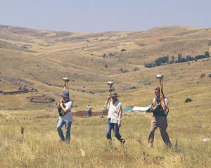 Kerkenes but will also eventually permit both the identification and the quantification of those cultural characteristics that underlay the creation and use of urban space. This has never before been attempted. At Kerkenes we have a city that was stopped at a single point in time when it was destroyed. Certain elements of its development over two or three generations leading up to the final destruction can already be determined, others can be postulated, and yet more will emerge as understanding increases. Predictions made through GIS can be tested, either by different survey techniques or through carefully positioned excavations. This is not restricted to our own site but could be applied to many ancient cities in both the New World and the Old World.
Above right: A total of 1,400,000 GPS readings were collected by kinematic survey with Trimble equipment using one base station and three roving antenna.
Kerkenes, in the future, will become a tourist attraction. Tourism is a mixed blessing for archaeologists. It disturbs our peace but greatly justifies our existence. Archaeologists are thus playing increasing roles in heritage management, a field in which GIS is firmly established.
It is not easy being pioneers in the use of new tools and techniques. When the way forward becomes unclear, or solutions to problems turn out to be elusive, there is no established body of experience to turn to. Funding for nonprofitable academic research is always difficult to obtain, and the current financial climate does not encourage generosity. Yet the excitement of the new is there. We are, we believe, changing the face of much archaeological method and theory. Survey, whether of regions or cities, has generally been aimed at telling archaeologists where they should dig in order to find what they are looking for, be it a tomb, a kiln, or a particular type of site. Our combination of noninvasive techniques, culminating in analytical GIS applications, is posing questions about the past that will only be answered through the development of new research designs tailored to test new theory that arises from new techniques.
For more information, contact Geoffrey Summers, Department of Political Science & Public Administration, Middle East Technical University, Ankara TR-06531, Turkey (tel.: 90-312-210-2045, e-mail: summers@metu.edu.tr) or the Kerkenes Project (fax: 90-312-210-6216, Web: www.metu.edu.tr/home/wwwkerk).