
University Collaboration and Imagery Help Columbia, Missouri, Prepare for Its Future
As many regions face expanding urbanization, increased pressure is placed on natural resources and existing infrastructures. New state and federal regulations mandate the monitoring and tracking of numerous issues, placing additional demands on agencies at the local government level. These factors are occurring at a rate at which municipal and local government resources, both labor and fiscal, cannot keep pace.
Growth assessments, infrastructure planning, risk management, and environmental impacts are among the many concerns shared by local and regional government managers. 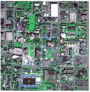 For effective policy decisions, these managers require timely and accurate information products. Unfortunately, their decisions are often based on inaccurate or nonexistent data. Such is the case for the City of Columbia, Missouri.
Left: Sharpened one-meter panchromatic IKONOS image shows density of urganization in the Columbia, Missouri, area.
Columbia, Missouri, rated as one of the best places in the United States in which to live, work, raise a family, and retire (Money Magazine, 2000), is also one of the fastest growing cities in the State. This pressure of urbanization is jeopardizing the City's treasured greenbelt system and protected hardwoods (namely oak and hickory), and placing a heavy demand on municipal planners and managers to seek better development and management approaches for new and existing urban areas.
In February 2001, the City officially adopted "Columbia Metro 2020: A Planning Guide for Columbia's Future," to serve as a focal point of its concerted efforts to meet the challenging urbanization problems and sustain the City's quality of living. The plan's success depends on up-to-date, timely, affordable data in manageable formats that can be shared between various government entities and the public.
Mapping as It Was
Traditionally, the City has relied on hard-copy aerial photos and contracting services for the development of its land cover and land use maps. These processes are time consuming, expensive, and difficult to update. In 1992, the City acquired SPOT panchromatic imagery to enhance their updating efforts. However, to pinpoint specific tree species and track development trends, planners needed higher resolution multispectral data.
"Preserving our greenbelt and the older oak and hickory trees found in this area is very important to this community," explains John Fleck, senior planner for the City of Columbia. "Relying on the older methods and data sources was limiting our ability to help identify climax forest areas and know for certain that we were in compliance with the City's protection ordinance."
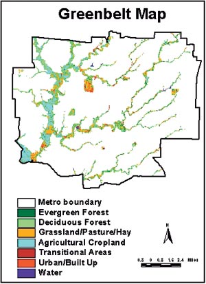 A greenbelt map was developed using the newly classified land cover map, showing only the land cover areas that fall within specified GIS layers. |
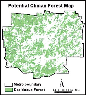 A statistical method in ERDAS IMAGINE was applied to IKONOS imagery to extract the potential climax forest from the delineated deciduous forest. |
Climax forest is defined as any woodland community of more than 20,000 square feet that is dominated by species such as oak and hickory, which are considered native forests in Missouri, and as such, must be protected. Identifying these forests will help the planning department to better manage the building permit process and ensure that these areas are not affected by new development.
"We've been identifying these areas by in-the-field surveys, which are costly and very time consuming," says Fleck. "As a result, we have only been able to conduct the surveys on an as-needed basis."
CARES Steps in to Help
Through collaboration with the Center for Agricultural, Resource and Environmental Systems (CARES) at the University of Missouri-Columbia, City planners are gaining access to geographic imaging resources and expertise that will expedite their current data processing practices and provide them with accurate and current information on which to base their plans.
CARES was established in 1992 with the purpose of helping people better understand and address agricultural, natural resource, and environmental issues using knowledge and information technologies. CARES is a cooperating partner with the Institute for the Commercial Development of Remote Sensing (ICREST), which is dedicated to integrating the commercial remote sensing activities of the University of Missouri, NASA, and the private sector.
In August of 1999, ICREST enrolled in ERDAS' Higher Education Annual Kit (HEAK) program, which is a multiseat discounted licensing program available to colleges and
 universities. Through HEAK, CARES acquired ERDAS IMAGINE geographic imaging software, including various add-on modules, to help students and researchers explore the realm of imagery and its practical application in real-world problems.
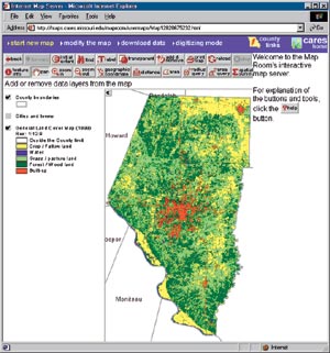
Left: CARES completely customized the tool bar in the ArcView IMS Web tool created for the city of Columbia and Boone County, Missouri. (Image credits: CARES).
In February 2000, ICREST received funding from Raytheon (Lexington, Massachusetts) to support CARES' collaboration with the City to cost-effectively develop current and accurate land cover information using high-resolution multispectral IKONOS satellite imagery (Space Imaging, Thornton, Colorado).
"We selected ERDAS IMAGINE for this project because of its powerful image processing capabilities and because of its tight integration with Esri products," says Ramanathan Sugumaran, Research Assistant Professor at the University of Columbia-Missouri.
Using the maximum likelihood classifier in ERDAS IMAGINE, the IKONOS images were classified to seven land cover classes: evergreen forest, deciduous forest, grassland/hay/pasture, cropland, transitional areas, urban/built-up, and water. Data sets previously created using ArcView GIS were combined with the IKONOS classifications creating a comprehensive, current, and accurate land cover and land use map that exceeded the City's expectations and satisfied a long-standing need.
"The difference these new image-based maps have made to the planning staff is dramatic," notes Fleck. "Before, our ability to keep up with the City's ongoing annexation and accurately track building permits was a real challenge, to say the least. Now, with IKONOS imagery, we can virtually count rooftops and identify building locations and their proximity to protected areas without leaving the office."
CARES also produced a climax forest map and a greenbelt map that display land cover falling within certain specified areas. Greenbelt maps assist planners and managers to protect sensitive areas, such as floodplains and hilly terrain, from development and preserve prime natural areas. The greenbelt map was developed using the new land cover map and clipping only the land cover areas that fall within specified GIS layers such as the 100-year floodplain boundary, parks, and public lands.
Web Tools for Access and Information Sharing
Traditionally, most of the geographical data sets, such as parcel maps, soil, geology, and administrative boundaries, were distributed to the public and other departments through photocopies, CDs, or disks. However, planners wanted simpler tools for distributing geographic data that would save them time and money.
In the final phase of the project, CARES developed a customized interactive Web-tool using ArcView Internet Map Server (IMS) software, HTML, Java, JavaScript, and Avenue programming. The process involves client/server transaction wherein the client makes a 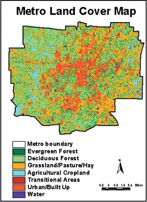 request to the server and the server, using ArcView GIS and the ArcView Spatial Analyst extension, gives the results back to the client. CARES plans to move the ArcView IMS-based tool to ArcIMS in the near future.
Right: Final classified land cover map created by processing IKONOS satellite imagery with ERDAS IMAGINE's maximum likelihood classifier.
The new Web tool allows any department/agency to access common geographical data and has made it easy for the public to browse the data.
The Final Analysis
The City's planning staff is convinced that high-resolution imagery is the ideal data source for their planning and management efforts.
"We plan to combine IKONOS imagery with the new census data, and then ultimately integrate it all into our GIS," says Fleck. "This combination of information sources will help us accurately inventory and manage developable land and help us update data that supports the transportation models we use to forecast future travel demand."
Using the high-resolution imagery to develop the new maps, along with the ArcView IMS-based data delivery system, has given planners a real boost in productivity and saved the City and its tax payers thousands of dollars. Plus, the new image maps will help planners provide accurate information to managers and elected officials as they pursue smart growth strategies that preserve the area's reputation for quality of life.
For more information, contact Ramanathan Sugumaran, research assistant professor (e-mail: sugumaranr@missouri.edu), or Daniel Zerr, research associate (e-mail: zerrd@missouri.edu).