


|
|
||
|
|
|
|
|
|
Esri Releases Major Component for Implementing Distributed GISArcIMS 3 Features Powerful Application Services Architecture
One of the key features of ArcIMS deals with direct "data streaming" between the server and a Web browser or other client. This capability allows users to integrate their local data with data served on the Internet, thereby providing a wealth of opportunities for users as well as data publishers.
"ArcIMS will revolutionize the way people share, access, and use GIS data," says Jack Dangermond, Esri president. "It represents a major step forward in creating a distributed GIS architecture. Agencies throughout the world will be able to publish data and services that users will directly take advantage of. Users will integrate distributed data with their local data, opening whole new ways of cooperating. This technology will leverage the vast amount of existing spatial information in GIS databases throughout the world."
Simple Wizard-Based Interface
"Everything you need is in a simple wizard-based framework that guides you through creating a map service, setting up your Web page, and publishing and managing your Web site," says Bernie Szukalski, ArcIMS product manager. Powerful, Intelligent Clients
Markup and MapNotes CapabilitiesArcIMS clients also include capabilities to dynamically edit or annotate maps. Markup and MapNotes capabilities allow users to post edits back to the server, facilitating the use of field devices recording changes to the server database. MapNotes allow for publishing notations for others to see and review, leveraging the interactive capabilities of the Web with GIS data. "We will see the creation of a vast spatially referenced communication," says Dangermond, "where people will be able to discover new ways to interact and share using the combined power of the Web and leveraging GIS information. I like to call this G-mail or geo bulletin board--emphasizing geography." Easy CustomizationArcIMS clients can also be easily customized to suit specific needs or purposes using standard languages like VBScript and JavaScript. These clients now offer unparalleled opportunities for end users and developers alike to create custom interfaces and applications. Open, Scalable ArchitectureThe unique ArcIMS architecture provides an open and flexible platform. ArcIMS easily scales from the smallest Intranet to the most demanding Internet. In addition, ArcIMS is compatible with a variety of other popular Internet technologies such as ColdFusion, Microsoft Transaction Server, Active Server Pages, and others. ArcIMS is a network- or server-based GIS and is highly complementary to ArcInfo 8 desktop GIS. "In the near future, Esri users will want to use ArcInfo 8 and ArcIMS together to create/maintain databases and publish information on the Web," says David Maguire, Esri director of products. ArcIMS 3 will soon be available and supports Windows NT and UNIX platforms. For more information on ArcIMS 3, please visit Esri online at www.esri.com/arcims, or contact Esri at 1-800-447-9778. Outside the United States, please contact your local Esri distributor. |
 ArcIMS 3 is the next generation Internet mapping and distributed GIS technology from Esri. ArcIMS is a software product that allows users to serve GIS applications and data to the Web and Intranet environments--and it is now available to order.
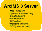 The new architecture contains many out-of-the-box application services such as mapping, querying, and geocoding but also allows users to plug in their own custom GIS service that makes use of local or distributed data sets.
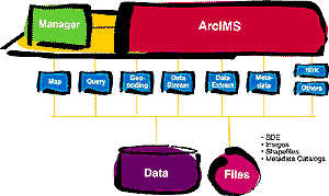 Esri users will be able to share and use each other's data anyplace, anytime. Data generated by sophisticated GIS professionals will be accessed by anyone through a simple browser interface. By increasing the accessibility to GIS-based information, organizations and society as a whole will maximize the use of their existing spatial data investments.
 ArcIMS features an out-of-the-box solution for creating, designing, and managing Internet sites that incorporate mapping and GIS capabilities. Its easy-to-use, yet powerful administration framework lets you author Web services and optimize your site. ArcIMS GIS includes everything you need from clients to servers to easily build, organize, and maintain your Internet mapping site.
 ArcIMS introduces powerful new clients in both HTML and Java versions. The ArcIMS Java clients support intelligent Internet feature streaming. This allows for true client/server interaction and lets clients work with locally cached data. Client operations no longer require a round trip to the server, and many operations are handled locally (e.g., map tips and map classification) on the client, yielding quick and efficient performance.