


|
|
||
|
|
|
|
|
|
Introducing OnPoint from Canada's Orion Technology Inc.New Application Serves GIS Your WayServing geospatial data on the Web is becoming increasingly common as IT managers realize the many benefits of the broad distribution of this valuable corporate resource.
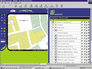
MapObjects Internet Map Server (IMS) Internet-based software uniquely comprises powerful GIS components that enhance both speed and customization. This is in sharp contrast to format-driven systems. serves your data the way you want to see it and serves it fast. This toolbox approach also allows developers to easily create applications that fully exploit software's vast capabilities. In addition, the ready-to-use Internet Starter Application templates allow users to begin immediately serving maps on the Internet. " is truly a 'best-of-both-worlds' software package," comments Jack Dangermond, Esri president. "We have brought to the market a unique software that meets both the power-user demands of the developer and the ready-set-go needs of the end user. We have successfully harnessed the power of the Web without sacrificing the unique needs of the individuals using the software. An analyst may want complete control over the display of her data. A counter clerk may want to view a simple snapshot of the same data. accommodates both quickly and efficiently." As a developer's tool, provides powerful components that can be easily customized to manage very specific tasks or provide wide-ranging capabilities. A Case in PointOrion Technology Inc. of Ontario, Canada, has created OnPoint, a -based application that takes full advantage of its GIS capabilities and adds powerful functions of its own. OnPoint provides GIS tools normally found on a desktop application to browser-level users. With a simple Web browser, the user not only has access to the corporate geospatial database, but can also customize his view of it. This feature alone provides significant impact on a corporation's decision making process by allowing the widest possible distribution of data without requiring any additional training on the part of the user. Comments Zul Jiwani, president of Orion Technology, "Our browser-based application differs from others in several significant ways. Certainly maps are currently being served up through a browser environment, but often the connection with the user is lost. For example, predefinitions may require that airports are always seen as red circles or parcels can only be seen at a scale of 1:10,000 or larger. The person that develops the application predetermines these restrictions. OnPoint is very different." With Onpoint, every browser user has total control over what he or she wants to see. So, through the browser users will get a list of all the data sets that are available within an organization. Users then choose what they want to see and what they want to label. Both of these features are independent of one another. They may want everything that is displayed also labeled, but it is not necessary. Users can also choose when they want to see it and when they want to label it. "You may say, 'I want to see a feature when the scale reaches 1:50,000, and I want to label it when the scale reaches 1:20,000,'" Jiwani continues. "You are also given the choice as to how you would like to label something. One user may want to label airports by capacity, and another user may want to label them simply by name. Now, here are two users viewing the same data with browsers at the same time, but each is able to view the map in the way that is most effective for them." OnPoint is also unique in the way that foreign languages are managed. Everything that is placed on the screen comes from a custom-designed database. This allows easy language localization of the application.
Continues Jiwani, "Once your map is in a Microsoft Word document, you have really empowered the user. You have allowed him to paste his custom-made map that comes from various databases and includes all of his customized symbology-in other words, all the specific information that he wanted included in that map-right into a Microsoft Word report." Another unique feature of OnPoint is a significant increase in speed because queries are managed by a very simple database access, as opposed to a map-based procedure. By avoiding the need to refresh the displayed map unless it is necessary, the system runs much faster. Concludes Jiwani, "I see OnPoint used to empower the average citizen. Why should I go downtown to register my child for a swimming lesson when I should be able to do it from home? With OnPoint, I can locate the nearest swimming pools, find out if there are any vacancies, and reserve a place. The average citizen is now empowered with the power of GIS." For more information, contact Zul Jiwani, president of Orion Technology (E-mail: zjiwani@orion-gis.com). |
 Unfortunately, customization and open data formats, which are commonly found in the corporate database, have often been necessarily sacrificed to standardization and proprietary file format to increase performance in these production line Web applications, forcing distinctly different departments with distinctly different needs to essentially look at the same data in the same way. "Any data, any way, as long as it fits within this template," Henry Ford may have said.
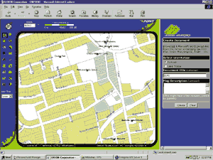 OnPoint also has unique printing capabilities. Normally, a browser allows screen capture printing only. OnPoint provides the capability to store templates in the database. Then, whatever map information is viewed is automatically placed in the template for printing. Alternatively, a Microsoft Word document can be created that includes all of the map information and related enhancements such as the index, text, legend, surround, and so on. This allows the user to edit the map in Microsoft Word. A PDF document may also be created.