


|
|
||
|
|
|
|
|
|
Esri's Professional Services Develops Internet Template Solution for Environmental ProtectionPennsylvania Protects Its Air, Land, and Water with GIS
The Pennsylvania Department of Environmental Protection (DEP) shoulders responsibility for protecting Pennsylvania's air, land, and water from pollution and for providing for the health and safety of more than 12 million citizens. This task, coupled with the above-mentioned resource management issues, prompted the DEP to look for methods with which they could leverage existing data that is scattered throughout the central, regional, and district mining offices on mainframes and local desktop computers into a State-wide data warehouse environment and make this data available for analysis and investigation over a State-wide Intranet. Esri's Professional Services Division began working with the DEP in 1998 to provide them with a State-wide environmental navigator network system. This system would maintain the functionality of the DEP's existing database infrastructure and custom applications while creating entirely new methods of viewing and analyzing the data. The question at hand was how to maintain the use of existing systems for management of data while expanding access, use and value of this data. "By utilizing Esri's state-of-the-art GIS technology and a flexible data warehousing system, the DEP has broken new ground, allowing resource managers to continue using existing investments in databases and database management applications while taking advantage of highly effective and efficient means of data distribution and use," says Peter Bottenberg, Esri project manager. These innovative uses of GIS and the Web include full exploitation of visualizing traditional information technology data in a spatial context and Web-based applications that train users on the use of the application while actually performing job tasks with interactive and consistently styled interfaces. The overall project goal was to develop an application that allowed all staff members (such as secretaries and permit reviewers) personal computer access to view and generate reports for permitting subfacilities within the State. The extended goal of the project was to provide the same information to the public via the Internet. System Architecture
Data and FunctionalityBased on the findings of an on-site assessment, Esri developed data migration procedures and loaded existing permit and GIS data provided by the DEP into an SDE database and installed the data on-site at DEP. The DEP GIS data is a State-wide database of roads, administrative features, hydrography, and other natural and cultural features. The primary goal of this effort was to perform "technology transfer" of the SDE data-loading process to DEP staff.
PFAS allows general query on any permit data as well as the resources that are available to the application (i.e., basemap data such as rivers, lakes, geology, game lands, forest lands, etc.). For example, a typical query might be phrased "find all Company X pesticide use permits within 30 feet/miles/meters of a stream." Conversely, a query might focus on a particular facility or subfacility type and work "in reverse" to find, for example, "all clients with wellheads within one mile of pesticide spray permits." Four query types are available for use with PFAS: tabular query, freehand query, simple spatial search, and permit interface query. After successful completion of the project, additional functionality of the system was added to make the data available to the general public via the Internet and to implement a Web-based educational tool (PENNLearn) to promote and assist DEP staff in learning about Pennsylvania's Web-based GIS. ArcExplorer was customized to allow any supported Web client (user) to connect with the DEP's Internet Web site to view the data. PENNLearnA Web-based learning system, PENNLearn includes practical self-assessment exercises with an emphasis on functional aspects of the DEP's Web-based GIS systems. PENNLearn is a state-of-the-art system that was designed to be expandable both in terms of user base and functionality. This smart lesson delivery system is based on a concept of practicality in teaching with computers that dictates that you only teach people exactly what they need to know and do. The result is that people become productive with technology much faster and, generally, with that productivity comes a confidence that increases the scope of learning about technology beyond the initial lessons. Since all staff do not learn at the same rate and will not enter the lessons with the same background knowledge, a user may identify a lesson from the lesson typology and then choose a level between entry, intermediate, and expert. Each higher level would assume less context is needed to perform the task. The final component is an automatic exercise evaluation system. Upon completion of an exercise, the user would submit the answers to the server. Routines on the server would evaluate the submission and notify the user by Web page with an evaluation of the exercise. For more information, contact Rodney Kelley, DEP (tel.: 717-783-4410, E-mail: kelley.rodney@dep.state.pa.us) or Peter Bottenberg, Esri project manager (tel.: 909-793-2853, ext. 1-1249; E-mail: pbottenberg@esri.com). For more information on PENNLearn, contact Boykin Witherspoon III, Esri (tel.: 909-793-2853, ext. 1-1799; E-mail: bwitherspoon@esri.com). |
 There are two main complex resource management issues facing large agencies and departments today: First, most agencies have large amounts of data often managed in different divisions on different hardware/software platforms in different physical locations. These disparate databases often are associated with large investments in infrastructure and custom data management applications. Second, most agencies are required to share all of this information with their employees and oftentimes with the public at large. Traditional methods of producing and distributing hard copies or individual users trading floppy disks of data are time-consuming and create situations where data lineage can be hard to trace. Also, end users of data compiled from various databases often do not have the tools or training to recognize and correct the inherent errors, such as data duplication, that can occur when combining data from various sources.
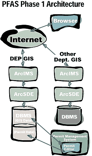 The DEP system demonstrates a system architecture based on a network-oriented distributed GIS that fulfills the demand of providing GIS functionality to a distributed set of users within the enterprise as well as on the Internet. The DEP system runs on Windows NT with Spatial Database Engine (SDE) for Oracle and ArcIMS, Esri's next generation Internet technology for serving up mapping and geographic analysis applications. As one of the first ArcIMS sites to be implemented by Esri, this site enhances the server-based architecture with software that allows users to also take advantage of client-side processing in addition to server processing. The strength of this system is realized when other GIS systems within an organization implement similar IMS systems. Thus, the information served with Esri's ArcIMS software to the Intranet or Internet can be made available to other IMS GIS applications. This eliminates the need to duplicate and maintain multiple data sets throughout an organization.
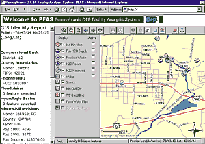 The Pennsylvania DEP Facility Analysis System (PFAS) was developed to provide customized spatial and tabular query, location, and reporting functions over a standard Intranet connection via a browser. PFAS supports the analysis of existing system subfacility data against various State-wide GIS data layers and represents the development of a spatial relationship between the data and the GIS databases.