


|
|
||
|
|
|
|
|
|
GIS Makes City Planning Management More Effective in the City of BeihaiBy Deng Weibo, Beihai Urban Information Center, Beihai, Guangxi, People's Republic of China
In 1992, with unique geographical advantages, abundant natural resources and preferential investment policies, Beihai attracted interest from around the world and became a "hot spot" for investment, and the City's construction came into a new stage of fast development. The rapid growth in City construction gave rise to severe pressure on Beihai's planning management and brought about many new problems, such as duplicated and overlapped land issuing (the same land parcel sold to two or more developers or the adjacent land parcels sold to different developers overlapped), new buildings occupying the planned road, and underground pipelines broken on construction sites from digging--all of which caused inestimable losses to the City and created potential troubles for future development of the City. City planning management basically relies on effective access to information about various aspects of the historic, present, and future situation of a city. Most of such information concerns space (including space positions and relevant attributes). So in 1993 when the Beihai City Planning Bureau (BCPB) made a decision to build the Beihai Urban Information System (BUIS), GIS-the best tool to handle spatial information-was chosen as the basic technology. BUIS is a large-scale GIS system that will command the overall basic information of the entire City. The general system design of the project was assessed and approved by a group of GIS experts headed by Professor Li Deren, a member of the National Science Academy of China, in 1993. Approved by the local government in January 1994, the Beihai Urban Information Center (BUIC) was set up to take charge of this project. In 1995, after two years' construction the Beihai Urban Planning Management Information System (BUPMIS)-the first phase project of BUIS-was completed and put into use in the BCPB, which resulted in office automation in BCPB. ArcInfo SelectedArcInfo software was selected as the basic supporting software due to its powerful capabilities of large-scale database management and spatial analysis; in addition, a Chinese version is provided, which is very critical to BUPMIS. Furthermore, it is easier to have access to ArcInfo technical support in China. The other software, including ArcView GIS, AutoCAD, Visual Basic, and FoxPro, are incorporated into the system to support the operations based on microcomputers. The hardware system consists of eight Sun SPARC workstations, 27 Compaq microcomputers, and a batch of peripherals such as color jet plotters, digitizers, scanners, and laser printers. The system is deployed among seven stories of the information building of BCPB and connected by a 10 Mbps Ethernet network so the data can be shared and office automation can be realized.
In land use and public facilities examining and approving processes, by using spatial analysis and other capabilities of ArcInfo, the user can overlap land use and other thematic data to find out the most suitable land position for the construction project according to its specific requirements, labeling the coordinates of the land boundary and making the land use redline map (land boundary map). With adequate computing accuracy, the duplicated and overlapped land issuing and narrow spaces between land parcels are prevented from happening. In City planning and construction examining and approving processes, by using the displaying, querying, mapping, and other capabilities of ArcView GIS, the user can easily display and query every spatial feature and its attributes (planning and current condition of the related parcel, related road redline, aerial and underground pipelines, planning design requirements, general layout plan, design scheme, records of previous examining and approving processes for the specific construction project, etc.). By using the designed automatic calculating tool, the user can accurately compute various planning indexes (such as floor area, usable floor area, building density, plot ratio, green coverage ratio), so as to help stipulate the planning design requirements, describe the planning index, and determine the design scheme (the facades, shapes, and layout of buildings) and construction drawings for a specific construction project; thus, the examining and approving quality is raised as efficiency increases. As a result, the examining and approving processes become more scientific and efficient and, with the data shared by the whole system, the data modified in one place will instantaneously be reflected in all the other places, so the possibility of conflicts among roads, buildings, and underground pipelines is eliminated. One chief staff member in the Public Facility Division of BCPB, when visited by a group of GIS experts who were investigating the GIS application, said, "As for my experience, the best part of the system is that the efficiency is greatly increased--about nine times that of the old system--and the mistakes minimized. Without the system I cannot imagine how we could properly cope with so many cases these last years." For more information, please contact Deng Weibo, systems analyst, Beihai Urban Information Center, Beihai, Guangxi 536000, People's Republic of China (E-mail: BUIC@ppp.nn.gx.cn or dengweibo@hotmail.com). |
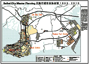 Beihai, one of the 14 Chinese coastal cities open to the outside world, has a population over 1.3 million, a total area of 3,337 square kilometers, and a coastline of 499.5 kilometers. It is situated on the northeastern bank of the Beibu Gulf at the southern tip of the Guangxi Zhuangzu autonomous region. Adjacent with Guangdong in the east, Hainan across the ocean in the south, Vietnam in the west, and the southwestern provinces of Yunnan, Guizhou, and Sichuan in the north, it is the most convenient sea gateway for southwestern China.
 After BUPMIS was put to use, the main professional work was supported by the system in BCPB. With the data related to current and City planning situations electronically digitized and stored in the system databases, ArcInfo and ArcView GIS can support the user to query information about land use, City roads, underground pipeline and their planning and construction status on the screen, which is the most frequently used and most required function in every examining and approving process. The user can either query the attributes by their graphical features or query graphical features by their attributes (e.g., query the investor by the land parcel or query the land parcel by the investor). The user can also conveniently choose to display the data stored in a different layer overlapped on the screen according to different requirements, making various comparison and comprehensive considerations, and can make various classified statistical summaries on land use, City roads, pipelines, facilities, and construction projects, providing a scientific basis for the decision making on the City's construction and development.