


|
|
||
|
|
|
|
|
|
MapObjects Provides Tools to ResearchersAfrica Country Almanac Project Assists Natural Resource Management in Sub-Saharan Africa
Inspiration for the Africa Country Almanac came from a UNIX-based ArcInfo ARC Macro Language (AML) software tool called the Spatial Characterization Tool, which was also developed by the Texas group. This system allows users to select a specific site (e.g., an agricultural experimental research station), obtain climatic information about the site, and then determine areas of similarity on a continental or even cross-continental scale. Users also can determine agro-ecological zones defined by specific climatic and environmental characteristics. The challenge for the almanac project was to take these powerful characterization tools and transfer them into a stand-alone PC format (Windows 95, 98, and NT), making them accessible to a much wider (non-GIS) user group.
The Africa Country Almanac was developed for users ranging from scientists to policy makers and offers a suite of access tools and country-level data, as well as textual information, enabling researchers to explore questions such as
A parallel role for the almanac project is that of GIS awareness building. Few agricultural researchers have previous exposure to the power of GIS. Providing researchers with direct access to spatial tools through the almanac will foster an increased understanding of this potential and lead to a greater demand for more sophisticated GIS analyses. Almanacs are already being applied to real-life research issues in sub-Saharan Africa. National agricultural program scientists in Kenya and Ethiopia have used the almanac to assess the relative importance of their maize research stations in representing the target environment for which they breed. Looking at the semiarid areas in Kenya, an almost complete coverage of the target environment was achieved with site similarity maps of existing research stations.
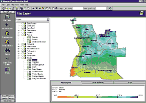
A key feature of the Country Almanac is climate surfaces, produced by interpolating data (with a splining technique) from more than 6,000 meteorological stations throughout Africa. Various climatic models have been derived from the original long-term monthly average surfaces. These models were originally targeted to the needs of agricultural researchers, as they include models such as favorable growing season and dry season, but they have also found much wider utility--they are already being applied to health-related issues, such as predicting the spread of malaria, and livestock research. Review versions of the almanac have already been demonstrated within the region and received very favorable responses from researchers covering a broad spectrum of disciplines. Upon release in September 1999, further training workshops in the region will be carried out by the CIMMYT and Texas A&M team. Jeff White, head of the GIS/Modeling Laboratory at CIMMYT, makes the following comment: "This is an entry-level package that nonetheless offers genuine GIS capabilities and will raise researchers' awareness and expectations concerning this technology." Although the almanac project has focused initially on sub-Saharan Africa, expansion to cover other parts of the world is already taking place. Funding to create an almanac for Nepal has already been secured, and a Texas almanac is nearing completion. John Corbett, the lead scientist from the Texas A&M team, reports that production of a prototype State almanac for Texas is complete. He notes that "the vast amount of data available for Texas led to considerable tool development in the almanac that can move back to the African Country Almanac as similar data (e.g., census) becomes available." For more information, contact John Corbett (tel.: 254-770-6636, fax: 254-770-6561, E-mail: corbett@brc.tamus.edu, Web: www.brc.tamus.edu/char) or Jeff White (tel.: 650-833-6625, fax: 650-833-6626, E-mail: j.white@cgiar.org). |
 Studies on agricultural and natural resource management often have limited impact because they are too site-specific. Research costs prohibit sampling a wide range of environments, yet results must be extrapolated over large regions. Tools being developed with Esri's MapObjects software are providing researchers with the means to address these issues. Agricultural scientists, natural resource managers, and policy makers working in sub-Saharan Africa are now able to access a completely new suite of spatial tools to assist them. Application developers in the Blacklands Research Center (part of the Texas Agricultural Experiment Station, Texas A&M University System) have worked in collaboration with the Natural Resources Group at the International Maize and Wheat Improvement Center (CIMMYT) to produce the Africa Country Almanac. The result is an easy-to-use, completely stand-alone system contained on CD-ROM that allows researchers in the region to visualize and understand their environments in all new ways.
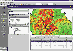 Funding for the almanac project came from the U.S. Agency for International Development (USAID) Office for Foreign Disaster Assistance, with the aim to produce country almanacs for nine sub-Saharan African countries by September 1999. (Three additional countries were completed by the Texas group prior to the collaborative work with CIMMYT.) Countries covered by the almanac project reflect the interests of both USAID (high priority for relief assistance) and CIMMYT (high importance of maize as a staple crop). These are Angola, Ethiopia, Kenya, Liberia, Malawi, Sierra Leone, Tanzania, Uganda, and Zimbabwe. (Zambia, Eritrea, and Somalia will be added in 1999.) "MapObjects and Visual Basic were chosen as the development tools because of the rich suite of functionality they provide," remarks Stewart Collis, one of the development coordinators. "Using MapObjects, we have access to a suite of spatial display and query tools. In conjunction with other ActiveX controls, this gives us the flexibility we need to deliver our analysis tools and data in an integrated, stand-alone package. Being able to customize our interfaces for particular user groups enormously increases the effective use of our GIS tools."
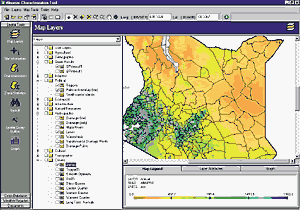 However, the relative importance of various stations proved to differ from what had been previously assumed. Marianne B�nziger and Julien de Meyer, two CIMMYT scientists based in Harare who are developing drought and low nitrogen-tolerant maize germ plasm for the southern Africa region, use the almanac to understand climatic variation in maize-producing areas. B�nziger says, "Our efforts to develop drought-tolerant maize germ plasm are yielding very promising results, and we have now reached the stage where on-farm trials are feasible. Selecting the optimal locations for these trials, for example, along different rainfall gradients, is enormously facilitated through the use of the Country Almanac."