


|
|
||
|
|
|
|
|
|
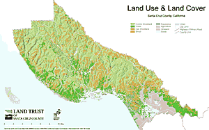
Land Trusts and Conservation Planning with GISBy Erik Schmidt, Land Trust of Santa Cruz CountyToday, many organizations and professionals employ GIS for a variety of conservation purposes. When it comes to permanent land protection, land trusts Above right: GIS is used to visualize landscape and natural resource diversity. Working almost exclusively at the implementation end of conservation, land trusts protect target sites through acquisition of fee title properties and conservation easements from willing landowners. Unlike most government land management agencies, land trusts buying or accepting property or easements do not have to contend with a time-consuming public review process or environmental impact requirements, and thus they can often move quickly and effectively to protect land. Frequently, land trusts step in where key habitat areas and other sites are threatened by development and are available for acquisition for only a short time; later, when funds can be arranged, public agencies can obtain part or all of the protected property. Such conservation partnerships have proven to be an effective way to establish and add to national and state parks, wildlife refuges, ecological reserves, and other public lands. Beneficial conservation partnerships are becoming commonplace in part because land trusts are proliferating. As of October 1998, according to the Land Trust Alliance, a national body coordinating and furthering the work of its member organizations, there were 1,213 land trusts in the United States, nearly triple the number of 15 years ago. These groups have protected more than 4.7 million acres of land--larger than the states of Connecticut and Rhode Island combined--and with public funding for land acquisition in the doldrums for more than a decade, their conservation efforts are more important than ever. Such successes notwithstanding, it is usually only the largest and best-funded organizations that have GIS expertise and technology on hand and in use. Land trusts wishing to build GIS programs face many hurdles including tight funding levels and frequent reliance on volunteer staffing. Although the need and potential applications for effective GIS data are tremendous, such technical information remains beyond the reach of most land trusts. This gap between GIS need and availability creates a perfect opportunity for partnerships and information sharing. Conservation-related data and GIS coverages that may seem fundamental to professionals and even students working for or studying at At the Land Trust of Santa Cruz County, on the central coast of California, we have been building a GIS for almost two years. Our program began with ArcView GIS software provided by Esri and a very modest investment in computer hardware. It has grown rapidly as more and more natural resource and land use data has been acquired from a variety of sources. The Land Trust's investment in GIS has complemented the organization's move toward a more proactive, science-based conservation strategy. In practical terms, this means that selection of land protection projects is now made with a GIS-generated evaluation of any potential site's fit in the County-wide and regional conservation landscape rather than on an isolated, case-by-case basis. Attempting to draw this landscape--a process that will almost certainly remain as ongoing as conservation data itself--has brought the Land Trust into close cooperation and data-sharing agreements with a number of agencies and organizations. Many of the GIS coverages we use, including parcel layers, zoning, roads, streams, and land cover, have been supplied to us in ArcView GIS shapefiles by the County Planning Department and the regional council of governments. State conservation agencies have provided additional natural resource data such as wetlands and watershed boundaries, and the local university has kindly reprocessed several GIS image coverages that the Land Trust could not otherwise have used. We are collaborating with The Nature Conservancy on an ambitious project aimed at mapping outstanding ecological sites in large portions of our County and region--again, a formidable task that our small organization could not have taken on alone. And finally, we have jointly initiated a farmland conservation program with the local farm bureau, making use of our ArcView GIS maps and their knowledge of the agricultural community. In addition to the cooperative benefits the Land Trust has reaped from its GIS efforts, we have applied digital mapping to perform outreach, fundraising, and illustration of grant proposals. In the future, we expect to advance our property and easement management program with the use of high-resolution digital aerial photos and GPS field data and to better target fundraising drives with ArcView GIS-based demographic analyses. It is an ambitious agenda that we hope and expect will make the Land Trust both more effective and more efficient at protecting land in Santa Cruz County. In just about every part of the country today, there is a land trust focused on saving the best natural and agricultural sites in its geographic region. As it has for our organization, GIS can present a range of new opportunities not only for the land trusts themselves but also for sympathetic conservationists and researchers who share their vision. Mapping and assembling any protected landscape can be accomplished only with the help of many partners and friends. A local or regional land trust working toward this goal can almost certainly use GIS assistance. With it great things can be accomplished. For more information, contact Erik Schmidt, Land Trust of Santa Cruz County (tel.: 831-429-6116, fax: 831-429-1166, E-mail: landtrst@cruzio.com). |
 are often the organizations closest to the action. Land trusts are private, nonprofit, community-supported organizations dedicated to conservation of land for ecological, agricultural, scenic, cultural, and other purposes. Their GIS needs create great opportunities for assistance and partnerships with more advanced or better-funded users. With assistance from Esri's Environmental Conservation program, a growing number of land trusts have acquired the tools to get the GIS ball rolling.
 universities, government agencies, and private firms can be of enormous use to local land trusts. More specialized data, revealing high-value habitat or wildlife sites and trends in local or regional biodiversity, can go far in helping to refine a land trust's conservation priorities and site selection criteria. Though, in many cases, land trusts do not incorporate biodiversity conservation as a stated goal, well-mapped habitat and species data in ArcView GIS shapefile format is the kind of welcome information that will often bring an organization to a new level of sophistication very quickly. Such partnerships can lead to conservation projects that benefit all who value parks, farmlands, wildlife habitat, and scenic viewpoints.