|
|
||
|
|
|
|
|
|
| Special Insert | ||
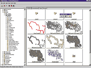
ArcCatalog: The Spatial Data Explorer and ManagerArcCatalog is a new ArcInfo application for locating, browsing, and managing spatial data. It resembles the Windows Explorer but can see down into databases and quickly view geographic data and metadata. It also hosts all data management tasks with easy-to-use interfaces and wizards. It provides the data-centric perspective to ArcInfo. ArcCatalog helps GIS database administrators maintain spatial and tabular GIS data for use by others in their organization. With ArcCatalog, GIS professionals performing spatial analysis can more easily fulfill their responsibility for metadata maintenance tasks following actual analysis and data conversion. And application users and entry-level analysts can employ ArcCatalog to discover the content and properties of core and derived GIS data.
Since it eases the complexity of geographic data management, the use of ArcCatalog results in a significant increase in user productivity. Users can select data sets with ArcCatalog and then drag and drop them into ArcMap for query and analysis. The Windows Explorer style of ArcCatalog makes it more intuitive than ever before to begin using ArcInfo software's powerful tools for data creation and manipulation. Data handled by ArcCatalog includes ArcInfo coverages, Esri shapefiles, geodatabases, SDE layers, ArcStorm layers, INFO tables, images, GRIDs, TINs, ArcSDE, CAD files, address tables, dynamic segmentation events, and other Esri data types and files.
|
|||||||||