


|
|
||
|
|
|
|
|
|
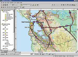
ArcGIS 8.1 Nears ReleaseArcGIS 8.1 marks a major breakthrough in the evolution of Esri software. The 8.1 release contains three key developments. First, it marks the unification of At right: ArcGIS 8.1 makes it easy to create cartographic quality maps. The term ArcGIS Desktop refers to ArcView, ArcEditor, and ArcInfo. ArcGIS OverviewThe ArcGIS software family is a scalable system for geographic data creation, management, integration, and analysis for every organization, from the individual to the global enterprise. ArcGIS consists of the following state-of-the-art software programs: ArcView, ArcEditor, ArcInfo, ArcGIS extensions, ArcSDE, and ArcIMS. At the 8.1 release, users will see a common architecture, common code base, common extension model, and single development environment for ArcView, ArcEditor, and ArcInfo. ArcGIS DesktopThe term ArcGIS Desktop refers to ArcView, ArcEditor, and ArcInfo. Although licensed separately, ArcGIS Desktop is a scalable set of software with the same All of the ArcGIS Desktop software include core functionality expected of a modern GIS. This list includes integration with Internet map and data services, geocoding, advanced editing tools, high-quality cartography, on-the-fly projection, refined support for metadata, wizard-driven menus, and direct read of more than 40 data formats. ArcView 8.1ArcView is the entry point into ArcGIS and provides core mapping and GIS functionality. ArcView 8.1 retains the same base functionality as ArcView 3.x while adding notable improvements such as ArcCatalog for browsing and managing data, on-the-fly coordinate and datum projection, customization with built-in VBA, new editor tools, support for static annotation, and much more. ArcView allows you to create and edit shapefiles and simple features in personal geodatabases. ArcEditor 8.1ArcEditor 8.1 is new software that includes all the functionality of ArcView and adds the power to edit topologically integrated features in a geodatabase or coverage. Additional functionality includes support for multiuser editing, versioning, custom feature classes, feature-linked annotation, and dimensioning. ArcEditor allows you to create and edit all Esri-supported vector data formats. ArcInfo 8.1Within the ArcGIS software family, ArcInfo is the top of the line. It includes all the functionality of ArcView and ArcEditor and adds the advanced geoprocessing capabilities that make ArcInfo the de facto standard for GIS. ArcInfo is the complete GIS data creation, update, query, mapping, and analysis system. ArcGIS 8.1 ExtensionsArcGIS 8.1 introduces a new set of functional extensions that operate with ArcView 8.1, ArcEditor 8.1, and ArcInfo 8.1. Esri reengineered the extensions to incorporate the best features of the existing ArcView and ArcInfo extensions. The list of extensions available for 8.1 include ArcGIS Spatial Analyst, ArcGIS 3D Analyst, ArcGIS Geostatistical Analyst, ArcPress for ArcGIS, ArcGIS StreetMap, and MrSID Encoder for ArcGIS. One of the key features of these extensions is that they operate with the entire line of ArcGIS Desktop software. Prior to ArcGIS 8.1, if Esri users needed to perform raster analysis they licensed different software depending on their core GIS software. They used ArcView Spatial Analyst with ArcView or ARC GRID with ArcInfo. In contrast, ArcGIS Spatial Analyst 8.1 can operate with ArcView 8.1, ArcEditor 8.1, or ArcInfo 8.1. ArcSDE 8.1ArcSDE is the gateway for storing and managing a multiuser geodatabase stored in a database management system (DBMS). By allowing joint multiuser editing and providing transacted views of a geodatabase, ArcSDE plays a fundamental role in collaborative GIS systems. ArcSDE 8.1 is tightly integrated with ArcEditor 8.1 and ArcInfo 8.1 for designing, creating, implementing, and sharing multiuser geodatabases. In a collaborative GIS environment, ArcView 8.1 acts as a client for viewing and analyzing geographic data. ArcSDE 8.1 supports Oracle, Microsoft SQL Server, IBM DB2, and Informix. ArcIMSArcIMS adds Internet mapping services to an ArcGIS system. The ArcIMS browser-based viewers and stand-alone ArcExplorer viewer are lightweight Web clients that complement the ArcGIS Desktop software. A significant new capability is that all ArcGIS desktop clients (ArcInfo, ArcEditor, ArcView, ArcExplorer, and ArcIMS Viewer) can now dynamically stream vector data across the Web from an ArcIMS server. These new layer types can be symbolized, mapped, queried, edited, and analyzed just like local data. They can also be saved locally for later use. This ability to access and publish geographic information across the globe is changing the use, scope, and impact of GIS. Geographic data providers using ArcIMS to publish live maps, downloadable data, and geoservices are registered on the Geography Network. For more information, visit www.geographynetwork.com. SummaryArcGIS 8.1 introduces a common architecture, common code base, common extension model, and single development environment for ArcView, ArcEditor, ArcInfo, and ArcGIS extensions. For more information, including the anticipated release date, call Esri at 1-800-447-9778 or visit the Esri Web site at www.esri.com/arcgis. |
 the ArcView and ArcInfo environments. Second, it introduces a new software program positioned between ArcView and ArcInfo called ArcEditor. Third, it adds a series of ArcGIS extensions that operate with the new software architecture.
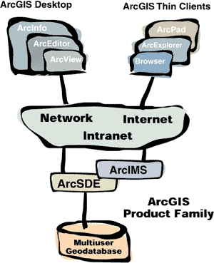 underlying executables and user interface. Additional functionality is enabled as you move from ArcView to ArcEditor to ArcInfo. This single integrated platform for geographic data creation, management, and analysis will dramatically increase usability and interoperability.