Web Sites Using Esri IMS Software
From the Baltic Sea to the Twin Cities, Internet Mapping Serves the World
Online mapping is a powerful tool, and the number of interactive mapping sites is growing. To keep you up-to-date, each issue of ArcNews discusses some of the latest Internet locations using Esri's software. If you would like to see your Web site featured in this column, please provide a description of your interactive mapping site and the URL to www.esri.com/imsregistry. Links to these and other Web sites powered by Esri technology are at www.esri.com/imssites.
Baltic Environmental Atlas
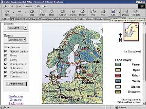 maps.grida.no/baltic
GRID-Arendal in Norway has released an environmental map server built with Esri's MapObjects Internet Map Server (IMS) for the Baltic Sea region. Users can create environmental maps of the area choosing from themes such as land use and population density and display them with other features of interest on customized maps. This new service concentrates on the issues related to the problem of eutrophication, which threatens biodiversity, reduces fish catches, and damages the recreational potential of coastal areas. Eutrophication is considered one of the most serious environmental and economic problems in the Baltic Sea. The atlas draws on data from the Baltic Sea region GIS, maps, and statistical database.
HealthQuery
www.healthquery.org
Powered by Esri's ArcIMS, HealthQuery was developed to enhance the health and health care of Californians and potentially the nation. HealthQuery is a suite of Web-based health planning tools for predictive modeling and simulation, geobased analysis, analysis of vital statistics data, and personal health risk assessment. HealthQuery tools are "public domainware" and can be used free of charge. Individuals can use HealthQuery to locate health care resources in their area or determine how healthy their community is. Organizations use the Web site's resources to view maps and tables of demographics and vital statistics and for predictive modeling and simulation. HealthQuery is being piloted in Los Angeles County with support from several local contributors including Esri.
Land Use in the Twin Cities Region
The Minnesota Metropolitan Council has updated the agency's Land Use Inventory for the seven-county metropolitan area it serves. Users can access the data through an interactive map powered by Esri's . This application shows land use geographic data and tabular data. Maps in PDF format are also available.
Official Street Finder for Rome (Stradario del Comune di Roma)
The local government of Rome, Italy, is using Esri's software to
power its Web site of interactive maps of the City. Users can view the
official street maps from the TeleAtlas StreetNet Connect database and
more than 2,000 points of interest throughout the City. This site is in
Italian.
ArcNews home page
|


