


|
|
||
|
|
|
|
|
|
Evolution to Enterprise via Cooperative Yet Autonomous DepartmentsLos Angeles City Departments Share Data for Special ApplicationsThe implementation of an enterprise GIS at the City of Los Angeles is taking shape as multiple departments develop the applications to meet their specific BackgroundWith an area of 465 square miles and a growing population of more than 3.7 million, Los Angeles is under constant pressure to expand development and to maintain and expand its services—fire and police protection, sewer and storm water pipeline maintenance, and refuse collection, among others. As a consequence, the City has consistently been open to innovation, and in the mid-1980s both the Department of City Planning and the Bureau of Engineering (BOE) started to automate their maps and Business processes. The Department of City Planning used ArcInfo to digitize its maps, creating a continuous spatial database—the first GIS database in the City. Its specific project need was to resolve inconsistencies between zoning and the City's general plan. The Bureau of Engineering used coordinate geometry to create precise map sheets containing the tracts, blocks, and lots in the City to serve as the official basemap for engineering projects. In the early 1990s, the City's information technology leadership recognized the benefits in terms of cost savings and efficiency that would result from adopting a "City-wide" approach to GIS. Central to building a City-wide GIS was applying standards wherever possible, including registering Above left: Los Angeles Fire Department's Computer-Aided Dispatch Application. At about the same time, the City began the process of selecting a standard GIS software platform. The BOE, with assistance from Psomas Engineering, ultimately settled on the Esri software platform and began the process of converting its highly accurate basemap data to ArcInfo format. BOE now maintains the basemap and distributes the files to City departments by using Esri-based tools it has largely developed in-house. Reconciling the City's data has made it possible for departments to share their data. To make this easier and also to make it possible for departments to use the vendor data available to the City, in the late-1990s the City's Information Technology Agency (ITA) began to create both a data warehouse, called the GIS Central Repository, and Intranet/Internet tools for accessing the data. The repository now contains more than 70 gigabytes of data distributed among more than 103 spatial layers, and it is continuing to grow. The Intranet/Internet tools, which are collected in an application called InfoLA and are based primarily on the MapObjects Internet Starter Kit applications, provide City departments with access to the data they need to perform daily functions; previously, obtaining the data from the source agencies was a daunting task. The Internet version of InfoLA (gis.lacity.org/infola/mainmenu.htm) also provides public access to data that can, for example, help determine the extent of floodplains relative to parcel boundaries. Expansion of the Enterprise GISLand use regulation. The Department of City Planning has continued to be active in implementing GIS. Most recently, Esri developed a database and application for the City's zoning information. Building the database required Above right: Department of City Planning's Zoning Information and Map Access System (ZIMAS), which allows planners to display zoning and other information for a property by specifying street address or other criteria. ZIMAS is based on Visual Basic, MapObjects Internet Map Server (IMS), and ArcExplorer software. It was developed and delivered incrementally by Esri Professional Services, giving City planners time to adjust the queries specified by the application's various screens. Fire ProtectionThe cooperative working relationship that developed as ZIMAS was being refined further when the City of Los Angeles sent two programmers to Esri in Redlands to learn how to use Esri software and to produce the mapping front-end application. Esri Professional Services programmers were on hand to help as the Fire Department and ITA programmers used MapObjects, SDE, and Visual Basic software to code (and enhance) the original application. The application is now complete, and the City programmers know the code inside and out, making it easy for them to upgrade and modify it. TransportationDeveloping GIS software by sending programmers to Esri was so successful that the Department of Transportation (DOT) decided to use the same strategy to develop GIS components that would enhance its existing (non-Esri) work order tracking and other applications. Among its many responsibilities, the DOT plans and operates the City's traffic control devices (including signals, signs, curb markings, and parking meters), and since Los Angeles has 6,400 miles of streets, 40,000 intersections, and 160 miles of freeway, identifying device locations quickly is important for efficient operation. To learn how to integrate GIS functionality in its applications, DOT sent two programmers to the Esri Learning Center for standard ArcIMS training and then to a weeklong application development session in the Application Development Center (ADC). There, with the support of Esri programmers, the DOT programmers developed the prototypes of spatial components for the work order tracking system. Esri then completed the software and installed it in Los Angeles. SanitationThe Solid Resources Collection Division of the Bureau of Sanitation (BOS) has also taken advantage of the enterprise GIS database. So that City residents can report missed refuse collections, dead animals, and so on, the Solid Resources Collection Division, like the Fire Department, operates a telephone hot line. To ask the right district to respond, the hot line operator must then determine which district is responsible for the caller's address. Some callers shorten their street addresses by leaving out "East," "Court," and so on, so this is not always easy. In August 2000, BOS contracted with Esri to develop an application that would make it possible to resolve address questions digitally. The resulting application, which is based on ArcLogistics software and had already been implemented by October 1999, lets operators display the data layers they specify (streets, collection districts, etc.) and returns a list of possible addresses if more than one meets the address specified. If necessary, the operator can then ask the caller for further information. ImplicationsIn Los Angeles, the number and variety of GIS applications will continue to grow at a rapid rate. The City has already implemented Internet applications that allow the public to find Census Centers and recreational facilities . For other cities, Los Angeles shows how to maximize efficiency yet satisfy different groups of users. Jon Harrison, Esri project manager, says, "Los Angeles has let each department take responsibility, which I think is a significant accomplishment, given the size and complexity of both the City and City government." For further information, please contact Mark Wolf, Information Technology Agency (tel.: 213-485-7750, e-mail: mwolf@ita). |
 Business needs while keeping the data and system resources they use consistent and coordinated.
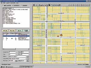 all spatial data to the official lot maps from BOE. At this time, the Department of City Planning was starting to update the detailed land use plan for each of the City's 35 community districts (the community planning revision program), and with assistance from Esri, it became one of the first departments to rework its spatial data to conform to the basemapping standard. The other City departments that have since introduced GIS into their Business processes have followed suit. In the resulting environment, the owner of each spatial data set is responsible for maintaining it and for doing so in a manner that allows the data sets to be integrated across traditional departmental lines.
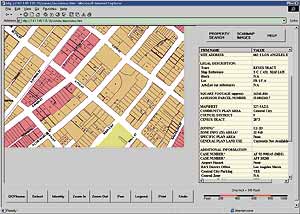 digitizing the zoning information on 1,900 cadastral map sheets and loading them into Esri's Spatial Database Engine (SDE). The application, called the Zoning Information and Map Access System (ZIMAS), allows planners to search for properties graphically or by entering addresses, street intersections, parcel numbers, cadastral map sheet numbers, and other criteria. It also allows planners to perform spatial data analyses, run series of queries about the zoning designations for parcels, and identify all of the zoning cases associated with a parcel. The application is also being used at the public counters at the City's one-stop center for planning and building permit processing. The Department of City Planning plans to integrate ZIMAS with its case-tracking system and document management in the near future.