


|
|
||
|
|
|
|
|
|
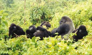
Mountain Gorilla Preservation Helps Rebuild RwandaAfrica's most densely populated country, Rwanda, is a former Belgian colony Right: Photo by Nick Faust, courtesy of the Dian Fossey Gorilla Fund International. On April 6, 1994, Hutu extremists in Rwanda murdered perhaps 800,000 people in 100 days. Many of the slaughtered were Tutsi and moderate Hutu, among them the core of the country's academic, scientific, and technology community. The carnage stopped when Tutsi rebels ousted the Hutu extremist government, launching the country into the difficult journey of rebuilding in the aftermath of war. Now, through collaboration with the Dian Fossey Gorilla Fund International and academic institutions in the United States and support from Oracle and ERDAS, an Esri Business Partner, and funding from the MacArthur, Turner, and Daniel K. Thorne foundations, the Rwandan government and scientists at the National University of Rwanda (NUR) are getting some of the critical assistance they need to build the country's first remote sensing and GIS center. The new center will become a data clearinghouse of geographic information essential to helping the country solve its social, economic, and environmental problems, as well as preserve the world's last remaining mountain gorillas. The Legacy of Dian Fossey and a New Conservation ModelFor 18 years, naturalist Dian Fossey lived in the Virunga Mountains of northern Rwanda, documenting the behavior of mountain gorillas and fighting for In 1995, the organization moved its headquarters to Atlanta, Georgia, and began working in earnest with other local researchers and scientists to use the latest geospatial technologies to advance their studies of human encroachment and gorilla habitat loss. Above right: Classifying vegetation in the Virunga Mountains using ERDAS IMAGINE and a Landsat Thematic Mapper image from 1987. Screen images on this page courtesy of the Georgia Tech Center for GIS. This collaboration resulted in the formation of the Center for Conservation Technology, a program of the Dian Fossey Gorilla Fund International. The institute unites the resources and expertise at the Georgia Institute of Technology (Georgia Tech) (see sidebar) and Zoo Atlanta with the Dian Fossey Gorilla Fund International; Clark Atlanta University's Center for Theoretical Study of Physical Systems; the Georgia Research Alliance (GRA), which is a public-private research funding organization for Georgia's universities; and the NUR. This promising new conservation model is poised to affect global conservation efforts by providing information and technology to other field scientists and governments facing similar threats to species within their borders such as pandas in China and elephants in the Congo. Using geographic imaging and GIS gives field conservation, ecosystem management, and endangered species protection a real boost, explains Clare Richardson, president of the Dian Fossey Gorilla Fund International. "Because we are a field conservation organization, it is imperative that we aggressively pursue more efficient ways to collect data, then have experts available to analyze that data, especially as it applies to habitat." Complicating matters is the fact that the existing vector-based maps are limited and in most cases extremely inaccurate, making the use of geographic imagery crucial in building an accurate GIS. According to Richardson, the use of imagery and geographic imaging tools will provide the new center with "a powerful land use planning tool." "The idea of tying GIS, geographic imaging, GPS, and communications together is a fairly new concept that we hope to explore through this collaboration," explains Nickolas Faust, principal research scientist and associate director of the Georgia Tech Center for GIS and one of the founders of ERDAS, Inc. In 1999, the newly formed institute received funding from the GRA, setting Above right: This image shows hyperspectral data collected in the Virunga Mountains highlighting the difference between natural vegetation inside the park and agricultural crops located outside and adjacent to the park. Inset: A three-dimensional view of road networks and a volcanic mountain range in Rwanda, generated using ArcView shapefiles and Landsat Thematic Mapper imagery that was draped over a digital elevation model displayed in IMAGINE VirtualGIS. "Technology transfer is very important," says Dr. Romain Murenzi, principal investigator at Clark Atlanta University's Center for Theoretical Studies of Physical Systems and chair of the Department of Physics. Dr. Murenzi believes that offering students the opportunity to learn using the latest technology gives the NUR a new advantage in recruiting college students. According to Dr. Bonfils Safari, dean of science and engineering at the National University of Rwanda, students will use the technology for applications in agriculture, social science, land use management, urban planning, climatology, and geology. "This will be very helpful for our country, especially for planners in the government ministries." Beyond Gorillas and BordersAlong with Dr. H. Dieter Steklis, chief scientist for the Dian Fossey Gorilla Fund International and a professor at Rutgers University, Faust is using ERDAS IMAGINE to combine GIS data from satellite imagery and hyperspectral data with demographic information including the database originally developed by Fossey in her studies more than 30 years ago. This information will establish a baseline for future analysis of habitat loss. "The carrying capacity of the area can be assessed by examining the quantity of preferred gorilla food," Dr. Steklis explains. "Based on that, we can determine how many gorillas the habitat can sustain." Repairing the nation's infrastructure and encouraging good land use planning Above left: Landsat 7 multispectral imagery was merged with Landsat 7 panchromatic imagery in ERDAS IMAGINE and then brought into ArcView Image Analysis for final enhancement and visualization and overlaying of the roads database. Note the park boundary on the image. The Dian Fossey Gorilla Fund International would also like to take this technology to other countries in which they work. "We want to provide the training and equipment for local universities to learn to collaborate internationally. Ultimately, we want to have centers for GIS and remote sensing dotted all around the globe," says Richardson. For more information about the Center for Conservation Technology and its work in Rwanda, contact Nickolas Faust, Electro-Optics Environment & Materials Laboratory, Georgia Tech Research Institute (tel.: 404-894-0021, fax: 404-894-6199, e-mail: nick.faust@gtri.gatech.edu). For more information about the Dian Fossey Gorilla Fund International, contact Clare Richardson (tel.: 404-624-5881, toll-free tel.: 800-851-0203, fax: 404-624-5999, e-mail: crichardson@gorillafund.org). Portions of this article are based on information reported in the Spring 2000 issue of Research Horizons, a publication of the Georgia Institute of Technology. Contact the Research News and Publications Office of the Georgia Institute for Technology for subscription information (tel.: 404-894-6986). |
 of only 26,000 square kilometers. Referred to as "the land of a thousand hills," its balmy climate and rich volcanic soil are excellent for agriculture, yielding the country's leading cash crops of sweet potatoes, coffee, and tea.
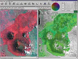 their survival until her death in 1985. In 1978, Fossey established the Dian Fossey Gorilla Fund International, and in 1992 the organization established its GIS and remote sensing program, working with researchers at Rutgers University.
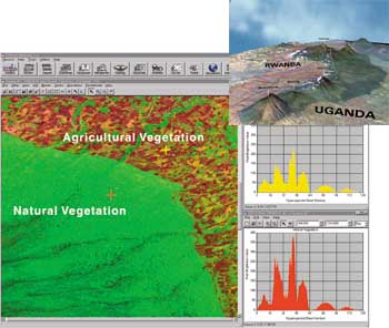 in motion the process of equipping the NUR with essential hardware and software. Using ERDAS IMAGINE, ArcView GIS, and ArcView Image Analysis, key NUR staff were trained to exploit imagery from various sources including Landsat Thematic Mapper, synthetic aperture radar, and hyperspectral data. Web-based course work designed by the Georgia Tech Center for GIS to train faculty and students will be launched some time in 2001.
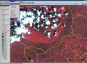 are important to the gorillas' long-term survival. It is also important to the Rwandan government given that gorilla tourism ranks second in the country's attractions for foreign investment. Beyond gorilla habitat analysis, GIS and remote sensing technology can also help the government update its maps, manage its agricultural lands, relocate refugees, and analyze the impact of their camps (areas known to suffer from deforestation due to trees being used for firewood and temporary shelters), as well as explore for minerals.