The Inaugural Worldwide Event
GIS Day a Tremendous Success!
 November 19, 1999, marked the first global GIS event in which more than 2,100 organizations using GIS technology opened their doors to schools, Businesses, and the general public to showcase their real-world GIS applications, reaching more than 2,400,000 children and adults in 91 countries. In addition, 34 U.S. states and 21 U.S. cities officially proclaimed November 19th GIS Day. November 19, 1999, marked the first global GIS event in which more than 2,100 organizations using GIS technology opened their doors to schools, Businesses, and the general public to showcase their real-world GIS applications, reaching more than 2,400,000 children and adults in 91 countries. In addition, 34 U.S. states and 21 U.S. cities officially proclaimed November 19th GIS Day.
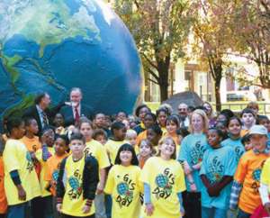
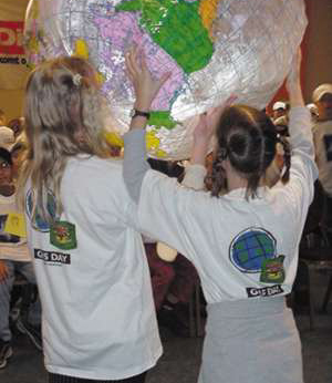
Above right: At the National Geographic Society in Washington, DC, Jack Dangermond (left) and Dr. Roger Tomlinson celebrate GIS Day with children from Murch Elementary School (Washington, DC). The globe was provided by Silicon Graphics Inc.
Here are just a few great examples of the 2,100 different events around the world as well as in different industries. Some events were as simple as decorating a bulletin board with maps or as complex as an Internet chat session with 55 schools. The point is that they were all effective ways of communicating the importance of geography and GIS.
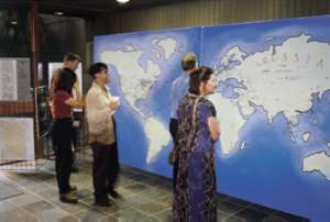
Sites Around the World
 India--During the week leading up to GIS Day, the Center for Spatial Database Management and Solutions (CSDMS) sponsored two events for professionals, a workshop for the mining industry and a conference on GIS for industrial applications. As November 14, 1999, was also Children's Day in India, CSDMS also sponsored a GIS run, GIS film festival, GIS poetry competition, and a GIS poster competition. India--During the week leading up to GIS Day, the Center for Spatial Database Management and Solutions (CSDMS) sponsored two events for professionals, a workshop for the mining industry and a conference on GIS for industrial applications. As November 14, 1999, was also Children's Day in India, CSDMS also sponsored a GIS run, GIS film festival, GIS poetry competition, and a GIS poster competition.
Romania--GEOSYSTEMS coordinated the efforts of geography teacher Steliana Miloiu and her 14-year-old pupils in an open geography lesson for grade eight using ArcView GIS software. It was the first time in Romania that GIS was brought into a school classroom at this level. The theme was "Getting to Know the Administrative Units and Natural Resources of Romania," and the pupils were also serving as field agents.
Singapore--Esri-South Asia invited all the schools in Singapore to showcase their GIS projects. The half-day event showcased projects from various schools ranging from 14-year-old students to university students. The event was open to the public. The attendance was approximately 300-500 people including representatives from the Ministry of Education.
Thailand--The Asia-Pacific Health Economics Network (APHEN), the MSc Health Economics Programme, and the MSc Environmental and Natural Resource Economics hosted a GIS exhibition on GIS applications in Environmental and Health Economics at the Faculty of Economics, Chulalongkorn University.
United States--
State and Local Government
 The City of Logan, Utah, hosted an open house and map gallery. Activities included a demonstration using new air photos to show people where their homes were along with demonstrations on how the City tracks growth and utilities. The City of Logan, Utah, hosted an open house and map gallery. Activities included a demonstration using new air photos to show people where their homes were along with demonstrations on how the City tracks growth and utilities.
The Pima Association of Governments in Tucson, Arizona, utilized their Web site to demonstrate GIS technology. The Web site had a treasure hunt theme and encouraged students to create simple spatial queries using several map layers. The object was to locate a specific label point.
The County of Orangeburg, South Carolina, showcased a teacher project entitled "Sands Across America." During her travels, this teacher collected many different types of sand and demonstrated, through the use of GIS, how sand is formed from different parent materials and transported and deposited on beaches and streams.
The State of Illinois hosted a two-day event in the State Capitol, which began on Thursday, November 18, 1999, with presentations/demos of GIS applications such as State police crime analysis, emergency management, etc. The Governor was in attendance along with the general public and many schools.
 The Massachusetts Office of GIS sponsored a map gallery at the State House where Massachusetts State organizations displayed maps of their current GIS projects. There was also an open house at the Massachusetts GIS offices where people made their own maps, went on a GIS-based scavenger hunt, or had a GPS lesson.
United States Federal Government
The U.S. Geological Survey Rocky Mountain Mapping Center, Colorado, conducted several demonstrations illustrating how GIS is applied in teaching science and geography at all levels as well as the application of GIS research in abandoned mine lands, urban growth, and infrastructure resource projects. In addition, several USGS staff conducted demonstrations of the use of GIS in Denver area schools.
The National Park Service, Hawaii, conducted presentations, discussions, and hands-on demonstrations with imagery and maps, incorporating data that is culturally significant to the community and classroom. The program was conducted in both Hawaiian and English for a second grade class in a full Hawaiian Language Immersion school. This project was jointly sponsored by other agencies in the region.
Transportation
Rutgers University, New Jersey, working with Isles, a nonprofit organization in Trenton, taught several classes about transportation/GIS-related mapping lessons prior to GIS Day. On GIS Day, the students traveled from Trenton to New Brunswick for a hands-on experience of what they had been learning in the classroom.
Environmental Management
 Montana Natural Resources Information hosted an open house at the Ray Bjork Technology Center. The event featured several activities including demos, hands-on experiences, and games. Activities were geared for school-age persons during school hours. Activities for the rest of the day (lunch hour, late afternoon, and evening) were geared toward adult interests. Map galleries were set up at different locations around town including libraries, schools, and Businesses. GIS professionals around the Helena area participated. Montana Natural Resources Information hosted an open house at the Ray Bjork Technology Center. The event featured several activities including demos, hands-on experiences, and games. Activities were geared for school-age persons during school hours. Activities for the rest of the day (lunch hour, late afternoon, and evening) were geared toward adult interests. Map galleries were set up at different locations around town including libraries, schools, and Businesses. GIS professionals around the Helena area participated.
Electric and Gas Utilities
The Boston Edison Company, Massachusetts, hosted a demonstration/workshop of a complex, completed, operational GIS system in an electric/gas/telecommunication utility environment.
Water/Wastewater Utilities
The Regional Water Authority, Connecticut, hosted an interactive workshop with upper-elementary school students. They analyzed maps using GIS and then made a city sandwich for their town.
The Montgomery Water and Sewer Board, Alabama, hosted an open house so interested citizens could visit the GIS Department. GIS analysts were available to discuss maps on display as well as demonstrate various applications.
Retail and Commercial Business
 Durham and Associates, Inc., Louisiana, hosted an open house with exhibits and presentations on GIS Day. The next day, November 20, 1999, they held a field day/educational fair with a 5K run/walk, map gallery, demonstrations, music, activities, and food. Durham and Associates, Inc., Louisiana, hosted an open house with exhibits and presentations on GIS Day. The next day, November 20, 1999, they held a field day/educational fair with a 5K run/walk, map gallery, demonstrations, music, activities, and food.
One World Mapping Co., Washington, conducted a workshop for 200+ elementary school children in the morning. In the afternoon, they conducted Business demonstrations for approximately 500 adults. Continuous informational materials were posted on their newly launched Web site.
Thanks to all the GIS organizations and users that took the opportunity to share their work with other people in their organizations as well as managers, students, visitors, and their community as a whole. It is your efforts and GIS contributions that made the first GIS Day a great success! GIS Day 2000 will be held on Wednesday, November 15, 2000. Please check the GIS Day Web site to learn more about upcoming plans and register to host a GIS Day 2000 event.
ArcNews home page
|


