


|
|
||
|
|
|
|
|
|
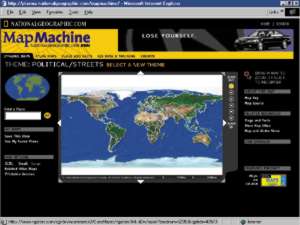
ArcIMS Powers SiteNational Geographic Launches New Generation of CartographyIn November 1999, the National Geographic Society unveiled the vastly expanded and enhanced www.nationalgeographic.com/mapmachine--the place to go on the Web to create, find, and download maps of every description. At the same time, National Geographic published the thoroughly revised and redesigned 7th edition of National Geographic's Atlas of the World.
To extend National Geographic's superb cartographic artistry and expertise to the Web, National Geographic has teamed up with Esri to produce a highly innovative Web site to access maps and geographic data online. Map Machine was built using Esri's latest Internet mapping technology, ArcIMS. The Web site--nationalgeographic.com/mapmachine--is an unlimited gateway to digital maps of value not only at home, school, and office, but also to professionals in conservation, forestry, real estate, agriculture, health care, and many other fields. The cornucopia of resources provided by National Geographic and Esri includes dynamic maps and geographic data organized by themes such as physical, cultural, and environmental. Users will find, for example, maps and information on recent earthquakes, transportation density, socioeconomic trends, political boundaries, crime statistics, ecological regions, land use zones, and natural hazards. From this online data, visitors to nationalgeographic.com/mapmachine may customize maps, viewing the data in layers. They can pan and zoom from global to local scales and search a gazetteer of two million place names. Maps may be bookmarked and e-mailed to others--all without charge. Related nationalgeographic.com features will be a mouse click away. An example of practical use of nationalgeographic.com/mapmachine could be an analysis of the recent devastating earthquake in Turkey. Users would be able to pull up a map of Turkey, zoom in on the troubled area, and overlay it with specific data such as geological fault lines, history of previous earthquakes, population density, and more. The map plates from the 7th edition of National Geographic's Atlas of the World are also available on the nationalgeographic.com/mapmachine Web site. Ensuring that the atlas will never be dated, patches will be available on the Web for downloading, printing, and pasting to the hard-copy atlas whenever there are changes in place names. nationalgeographic.com/mapmachine will be in the near future a continuously updated source of map information including not only changes to names of places as they occur but also daily updates to weather maps and even satellite images of the earth. Much of this information will be provided by the many federal agencies that maintain and update maps in the public domain including the National Oceanic and Atmospheric Administration, the National Aeronautics and Space Administration, the Jet Propulsion Laboratory, the U.S. Geological Survey, the Environmental Protection Agency, and others. Ultimately, a specific focus of nationalgeographic.com/mapmachine will be service to the conservation community. "National Geographic's new Web site will serve as a vital source of information to support informed and responsible decisions in managing our planet's resources," said Allen Carroll, chief cartographer of the Society. "Issues such as sustainability, biodiversity, livable communities, and the quest for balance between economic growth and resource conservation have become critical as population growth and global economy surge into the new millennium." 7th Edition Atlas of the WorldThe 7th edition of National Geographic's Atlas of the World makes more use of satellite imagery and digital technology than any previous National Geographic atlas. At the heart of this spectacular atlas are more than 75 political and physical maps that draw on National Geographic's new digital cartographic database to achieve the highest level of precision. A 136-page encyclopedic index of more than 140,000 entries lists every significant city and natural feature on the planet, and an improved system of map keys and locational devices makes it easy to navigate through the book's wealth of information. Information for travelers includes time zones, airline distances, temperature and rainfall statistics, maps of 243 major cities, and a glossary of important foreign terms. This atlas was created by a team of some 50 cartographers, designers, editors, researchers, indexers, and others and is a state-of-the-art reference. "Together the atlases provide the best of both the print and the Web worlds--a very powerful combination," said Carroll. "The print atlas provides convenience, unmatched detail, and scope with its big pages full of information and beauty. The interactive atlas provides up-to-date information that is easily customized as well as access to a huge and growing volume of maps, imagery, and other geographic data." For more information about nationalgeographic.com/mapmachine, contact Mike Tait, Esri (tel.: 909-793-2853, ext. 1-1764; e-mail: mtait@esri.com). For more information about the 7th edition of National Geographic's Atlas of the World (ISBN 0-7922-7528-4; $125; November 1999), contact Sarah Clark (tel.: 202-828-5664, e-mail: sclark@ngs.org). |
 "The complete overhaul of our signature atlas and the launch of a new, powerful map site on the Web harness the latest digital technology to a century of National Geographic's renowned cartographic expertise to present nothing less than map tools for a new millennium," said National Geographic Society President John Fahey.