


|
|
||
|
|
|
|
|
|
For Land Records Information SystemCook County to Implement World-Class GIS
"Two issues that led to the GIS implementation were the processing of land information and the dissemination of information to the public," says Alan Hobscheid, GIS Manager, Cook County. "As part of this effort, the County wanted to automate its tax maps, which are currently maintained manually. Once the system is up and running, we will integrate and streamline work flows to more efficiently manage information internally within the County, and to optimize how we distribute that information to the public."
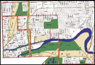
After an extensive evaluation period that included a feasibility study, a request for proposals, vendor presentations, and benchmarking, Esri was selected this year by an interagency committee representing numerous County agencies and departments. Embracing Esri's Next-Generation GIS SoftwareAt the core of the Cook County GIS initiative is the acquisition of Esri's next generation of GIS software including ArcInfo 8, the most significant release ever of ArcInfo professional software; ArcSDE; and ArcIMS. ArcView GIS and MapObjects will also be acquired. Initially there will be approximately 60 GIS users, with 20 ArcInfo users and 40 MapObjects and ArcView GIS users. However the system is being built to accommodate growth for up to several hundred users. ArcSDE 8 will run with IBM DB2 to manage the spatial data in a relational database environment. ArcIMS 3 will be used for creating, designing, and managing Cook County Web sites with mapping and GIS capabilities. With ArcInfo 8 software's new component object model and object-oriented architecture, new user interface and applications, geoprocessing server, and more, Cook County will have one of the most state-of-the-art implementations of its kind. ArcIMS will provide direct data streaming between server and client; application services such as mapping, querying, and geocoding; a simple wizard-based interface; easy customization; and powerful, intelligent HTML and Java clients. "The dissemination of information was also something the County wanted to optimize using ArcInfo," says Hobscheid. "Depending upon a user's needs there will be a variety of ways to access this data. For example, applications may be built utilizing MapObjects, and then accessed through ArcView GIS." Streamlining Work Flows, Integrating Government AgenciesOne of the major goals of the County's GIS Initiative is to automate its tax mapping procedures. With a population of more than five million, the County maintains more than 8,800 tax maps containing 1.6 million parcels encompassing almost 1,000 square miles. The processing of property tax data involves several County agencies. These agencies are the County Assessor's Office, the County Clerk, the County Recorder of Deeds, and the County Treasurer. The GIS will streamline the flow of information between these offices and ensure that each office has access to the most current data. In addition to streamlining the tax mapping process each of these agencies will see enormous benefits from the GIS in their individual day to day operations. With GIS, the County Assessor can easily access digital information related to a parcel, and then make property value assessments. "GIS will help the Assessor more accurately assess property and map this information based on their analysis," says Hobscheid. Also, the Assessor has a related project that includes the capture of image data for each parcel in the County. Through the GIS, users will be able to access image information as well as to map and access other data. In addition to replacing the manual methods for producing tax maps the County Clerk will also produce additional maps such as taxing district maps and municipal boundary maps. The County Recorder will use GIS to help in its duties of managing change of ownership and property information and land surveys for new parcels. The Treasurer will use the System to help manage the collection and distribution of property tax revenues. The result will be a reengineered workflow process. In the past, to get information from one of these offices, someone would have to go through several steps to look up index files and identification numbers to locate needed paper documents and maps. With GIS, this process is streamlined and automated. From a desktop PC a user can access a shared database and get the same information used throughout the County. "We discovered that many of our efforts were duplicated, that departments were managing the same information separately, and that these departments were unaware of what the other was doing," says Kevin Burden, Deputy Assessor, Cook County Assessor's Office. "Users in a number of departments will be able to access information on their own in a matter of minutes." Individual agencies throughout the County will be able to integrate their information with information in the Cook County GIS. For data dissemination, the County will provide information to its constituency via the Internet, where with a few button selections, a person can access land related information for parcels throughout the County. Using a County-wide Intranet, Cook County government employees can access information quickly and easily with a few key strokes rather than having to go from one department to the next to put in a request for a document, file, or paper map. According to Cook County officials, integrating data from various sources and spatial enabling that data to users across government agencies will result in decision makers having the ability to look holistically at important issues. For more information, contact Alan Hobscheid, Cook County Department of Office Technology (tel.: 312-603-1399, fax: 312-603-9904, e-mail: aahobsch@wwa.com). |
 Cook County, Illinois, under the leadership of Cook County Board President John H. Stroger, Jr. and Assessor James M. Houlihan, is embarking on one of the most ambitious and forward thinking local government GIS projects to date, using ArcInfo 8, ArcSDE, and ArcIMS to reengineer how the County manages its 1.6 million cadastral records. The multiyear, $15 million implementation will be one of the most advanced of its kind and will completely change the way a local government like Cook County integrates information from several independent departments and enhances access to that information for its citizenry. As Assessor Houlihan points out, "Our goal, first and foremost, is improved public service. That means giving taxpayers the tool necessary to access critical government information. We believe in the value of GIS because we are convinced of the value of information. It breeds the type of understanding that is essential to establishing confidence and faith in government."
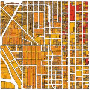 "Cook County is taking a leadership role in local government by using the latest GIS technology to improve fundamental operations and create a modern land management system that cuts across government," says Jack Dangermond, president, Esri. "The GIS at Cook County will be shared by County agencies and departments and will give both government employees and the public fast, reliable access to many types of information about property. The Cook County project is important for both Esri and the whole user community because we are using this effort to further improve the way our base technology serves land information systems."