


|
|
||
|
|
|
|
|
|
MrSID Imaging Language: Enabling Your World
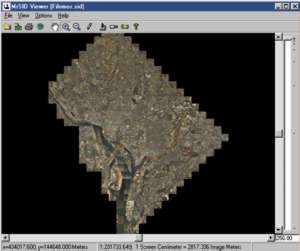
Above: At Full Extent, the data is a single, seamless image of Washington, DC, at a ground resolution of 0.2 meters. (Image Copyright © of VARGIS LLC of Herndon, Virginia.) For those of you who think a compressed image is synonymous with poor image quality, think again. Say goodbye to the days when image quality depended on the file size of the image, and say hello to MrSID.
At right: the image at Zoom Level 3. So, how does this work? Basically, there are two categories of image compression: lossless and lossy. Lossless compression generates an image identical to the original by using mathematical techniques to minimally reduce the file size without removing any data. On the other hand, lossy compression analyzes the image data and eliminates data that is not visible to the human eye. By removing the extra unnecessary data, file sizes are reduced dramatically. However, when the image is decompressed, all the values of the original image will not be restored.
Wavelet Versus Fractal CompressionFractal-based compression is another method of compressing raster imagery, which may create very small files and can produce visually acceptable results by converting an image into a representation of the original image. Compression is actually achieved by dividing the image into blocks and then comparing each one to a large number of similar blocks to determine which may be substituted for the original. The blocks are approximated separately so that the boundaries between each block may or may not be accurate. This technique is usually not acceptable within a GIS because an imprecise approximation of the original image is created. Fractally compressed imagery is not necessarily geometrically accurate. MrSID differs because it achieves compression by reducing the accuracy of the numbers that define the image data, yet maintains the relationships between the individual pixels of the original image and does not result in blocking artifacts. Geometric accuracy is completely maintained.
Above: The image at zoom Level 1. Putting MrSID into ArcView GISThe fully integrated MrSID extension in ArcView GIS enables users to have access to massive georeferenced images that, until now, have been simply too large to handle in traditional GIS software. MrSID's ability to encode enormous image files into easily manageable, high-quality MrSID files makes it ideal for compressing maps, satellite images, and aerial photographs. The MrSID Portable Image Format works similarly to other image file formats, except with faster redraw times and easier manageability. MrSID quickly creates many resolutions from the same file. From there, you have complete control to zoom, pan, and navigate through the image on the fly. And when you zoom into an image, the quality gets better with every click instead of worse. MrSID's patented selective decompression allows instant access to any part of any image. In other words, MrSID selectively decompresses and renders only the exact portion of the image requested instead of the entire file. Gone are the days of shuffling through disks of image tiles or painstakingly panning through a huge mosaicked image to focus on a particular location. MrSID's patented mosaicking feature allows multiple image tiles to be mosaicked seamlessly into a single high-resolution image that can be panned and zoomed in seconds locally or over the Internet. Viewing MrSID Imagery in Esri ApplicationsLizardTech and Esri are committed to providing viewing capabilities for the MrSID Portable Image Format in a broad range of Esri software. There is a fully integrated extension inside ArcView GIS 3.1 and 3.2 for viewing massive, georeferenced images. There is also support for MrSID in ArcInfo 8, MapObjects 2, ArcIMS 3, ArcView Image Analysis, and ArcExplorer 2. This MrSID functionality allows you to browse gigabytes of imagery that, until now, have been difficult to handle in traditional GIS software. Information About LizardTech Products
For more information contact LizardTech (tel.: 206-652-5211 or Web: www.lizardtech.com). |
 Raster imagery is rapidly becoming an essential part of any GIS. GIS professionals are using enormous images to make mission-critical decisions every day. With this imagery comes a headache. The frustration associated with viewing and transferring huge files and the extra costs of additional memory and high-power computers to display these monstrous images can be very significant.
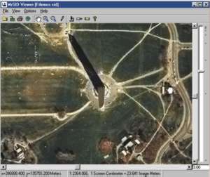 LizardTech's MrSID reduces image file sizes by at least 95 percent, without compromising image quality, while maintaining the geometric accuracy of the original image. The MrSID Portable Image Format enables true portability of massive images. More than just a compression utility, MrSID is a complete imaging language.
 MrSID from LizardTech uses a lossy compression technique in that data is purged; however, it achieves visually lossless compression even at ratios of 20 to 30:1. MrSID's patented compression technology is based on wavelet technology. Wavelet algorithms also take into account the fact that the amount of detail may vary within the image, which is perfect for geospatial images that tend to represent detailed urban areas as well as large areas of no detail within a single image. This technique transforms the bits of the image using a mathematical formula to combine the advantages of lossy and lossless compression: small file size, excellent image quality, and complete geometric accuracy. This is a very unique and powerful combination.
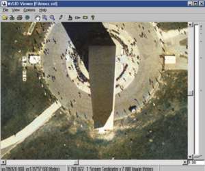 The accuracy and amount of compression achieved in a fractal-based image compression depends on how fractal-like the original image is. A fractal is a geometric shape that can be subdivided in parts, each of which is a smaller copy of the whole. Fractals are generally self-similar (parts look like the whole) and independent of scale (they look similar no matter how close you zoom in). Unless the imagery you work with fits this definition, you will achieve higher compression with better image quality by using a different type of encoding. When considering the complexity of geospatial images, fractal compression is not comparable to wavelet compression.