


|
|
||
|
|
|
|
|
|
Acquires ArcSDE, ArcFM Viewer--Plans Migration to ArcFMAlliant Energy Extends GIS Throughout Wisconsin
Out of the approximately 6,000 utilities in the country, Alliant Energy is among the top 50, making it one of the larger utilities in the country. And one of its three operating units, Wisconsin Power and Light (WP&L), is embarking on an implementation that will provide up to 300 field-workers and other employees with spatial data access for solving all types of problems, from facility replacement to service requests to property management, and more. This kind of spatial data access will change how WP&L does Business and will help them better serve customers, maintain optimum service reliability and safety, and ultimately operate in a more cost-effective manner. "We don't see the future being paper," says Terry Schmidt, manager of Geographic Information Services, Alliant Energy. "The future is electronic including our spatial data. So much of what we do is tied to a geographic location; it is important to make spatial data available to as many people as possible." Wisconsin Power and LightThrough its operating units, IES Utilities Inc., Interstate Power Co., and Wisconsin Power and Light, Alliant Energy serves more than one million customers in Iowa, Illinois, Minnesota, and Wisconsin. The company's service territory covers 54,000 square miles in the heartland of America and includes 9,700 miles of electric transmission lines and 8,000 miles of natural gas mains. Utility operations are headquartered in Cedar Rapids, Iowa. WP&L, which has been a user of Esri software for five years, serves 450,000 gas, electric, and water customers throughout the State of Wisconsin. Alliant Energy is based out of Madison, Wisconsin. Recently, the company decided to acquire ArcFM Viewer and SDE software to implement a client/server solution that will extend GIS to many new users and integrate spatial data to other information systems. "A successful GIS is not just software in place on workstation terminals or desktop PCs; it's technology, people, and methods," says Jeff Rashid, Utility Solutions Group, Esri. "Wisconsin Power and Light understands this, and they are taking the lead in implementing a GIS that empowers its employees."
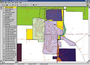
As WP&L began building its spatial database on facility assets and property records, the company began to achieve greater Business results managing information in computing environments versus paper formats. Data updates could be made quicker, data sets could be integrated and analyzed with greater efficiency, and maps could be generated faster. And with the benefits of managing information in a computerized environment came the vision of making spatial data available to more than just the centralized map group. For this, the company consulted with Esri and Miner and Miner, which resulted in the acquisition and planned implementation of a network of desktops linked to one centralized relational database management system that could serve spatial data with the same speed and efficiency as tabular data. Completed in the first quarter of 1999, Alliant Energy is providing viewing tools to field workers using ArcFM Viewer. The initial rollout included 200 engineering technicians and designers in 16 locations. SDE is used to store spatial data in Oracle DBMS software. The company will eventually migrate to ArcFM software. The reason for extending spatial data throughout WP&L, according to company officials, stems from one simple idea: better serving customers. "Paper maps are out of date the moment you print them," says Schmidt. "We want to provide the most up-to-date information to better serve our customers. If someone calls in and asks about new service or changed service, we want to be able to tell them right now what's going on." Client/Server GIS"We've come to realize that we want to keep data in one place where it can be accessed by several departments, whether it's a GIS system or some other system," says Schmidt. "That's the goal we are working toward. Since most of what we do has a geographic component to it, it makes sense to integrate data, applications, and information systems using GIS." Currently, spatial data is integrated with several other systems at WP&L. The work management system interfaces with GIS so users can bring as-built information into the GIS and automatically send back information, such as facility and switch numbers, to the work management system. Graphics from the GIS can be pasted into work management job packets as design sketches. Facility and land base information are used in the outage management system and the distribution management system for key applications such as line patrol inspections, system planning, and more. Customer transformer locations are sent from the GIS to the customer service system for customer service requests. Property data from the GIS is used to manage property accounting information.
Employees such as transmission engineering designers, real estate and right of way coordinators, customer service dispatchers, and more will use ArcFM Viewer in the future to query information from their desktops. "When we selected Esri, we felt like they had more of a corporate focus for their software, rather than a narrow one," says Schmidt. "We are pleased with the extent that we have implemented our GIS. Now we are working towards setting up the system to support many more users. This is exciting." For more information, contact Terry Schmidt, manager, Geographic Information Services, Alliant Energy (tel.: 608-252-3095, e-mail: TerrySchmidt@alliant-energy.com). |
 Utilities that have operated for decades under the staunch framework of regulatory compliance, the idea of deregulation, i.e., moving to a competitive marketplace, can be a little scary. That is why many companies are turning to technology and the potential it holds for giving decision makers the right information to make the switch from regulation to deregulation. With high-tech mania sweeping the industry, companies are also recognizing the potential for leveraging spatial data into the information mix of things.
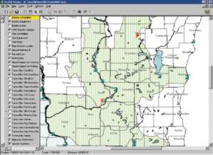 WP&L originally acquired ArcInfo professional GIS software, along with Miner and Miner PowerTools, for planning, design, and operation of its power systems. WP&L maintained a centralized mapping group that supported its Business and engineering operations. Data on the field facilities was stored and managed by the centralized mapping group, updated using Miner and Miner PowerTools and ArcInfo software, and then published in the form of hard-copy maps.
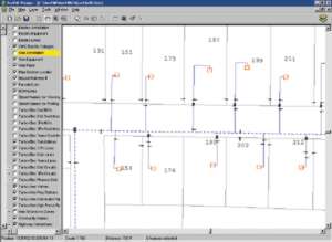 "We've been able to do things that simply have not been done before," says Schmidt. "For instance, if you start to look at gas leaks over a 10-year period, it's great to get a spreadsheet out, but until you can see that information spatially, the patterns don't jump out at you."