


|
|
||
|
|
|
|
|
|
Consortium for GIS in Water Resources to Design New Object ModelsBy David R. Maidment, Director, Center for Research in Water Resources, University of Texas at Austin
With the advent of the new object modeling and geodatabase concepts in ArcInfo 8, GIS will experience a substantial increase in power and capability over the traditional georelational model. In order to exploit the power and capabilities of this technology for water resources, a concerted research and application prototyping effort will be required to arrive at the most effective data models for water resource organizations globally. Moreover, done correctly, such an effort will create a standard for implementation and interoperability that will facilitate rapid deployment of the technology. The idea of the consortium is to provide a means for interested individuals and organizations to work together to accomplish these goals. The object model of rivers and watersheds is being built around a representation of the river network. Network routing in GIS operates on a single line representation of the system, but in water systems, reducing the river network to single lines is complicated by the presence of water bodies such as lakes and reservoirs. These are represented in the network by tracing through the center of the water bodies and connecting the water body centerlines to the regular blue lines for the rest of the river network. As part of the development of the National Hydrography Dataset (NHD), centerline files have been developed by the USGS and EPA for all the water bodies in the United States appearing in 1:100,000-scale maps. For more information about the NHD, see nhd.usgs.gov. The river network and its watersheds form a duality: for every location on a river there is a corresponding watershed; within every watershed there lies a corresponding river network. The watersheds represent the landscape view of water resources within which the effects of spatial patterns of soils, land use, land cover, and urban development are determined. Drainage direction on the land surface is defined using a digital elevation model. Maps of rainfall and climate variables are overlaid on the landscape to specify input data for hydrologic models.
Natural water flow is driven by weather events and is constantly changing through time. An object model for rivers and watersheds must be able to incorporate and display time series data, either regularly or randomly spaced in time. Fortunately, in ArcInfo 8 a time series database can be incorporated in the model template as an object class just like a set of spatial features. With ArcInfo 8, Esri supplies a collection of standardized objects and tools for customizing them into more complex forms. For a particular application such as rivers and watersheds, a template can be created that defines the various classes of customized objects, specifies their properties (including permissible ranges of property values), lists their behaviors, and describes how the object classes are linked through relationships. This template is used within ArcInfo 8 to import geospatial data into a relational database management system to fill the various components of the model. The Unified Modeling Language (UML), recently developed in the computer industry, is used to define object model templates. This language is implemented using a computer-aided software engineering (CASE) tool. Model development for the consortium is being done using the Visio Enterprise CASE tool. For more information, see www.visio.com.
A river reach can be represented as a refined version of a complex edge object. The reach has junctions at its endpoints. Interior to the reach there are different types of junctions representing gauges and dams or reservoirs. Other edges can join the complex edge at interior junctions, representing tributary reaches or other types of network features such as canals or piped drainage. Prototype models representing the stream network within the City of Austin and the Trinity River Basin, Texas, are being used to test the object model.
In order to provide focus and structure for the consortium's activities, plans have been made for three years of research and development, at the end of which the members may decide that the goals have been accomplished and terminate the consortium's activity, or they may decide to continue working together on subsequent issues. The consortium's Web site is www.crwr.utexas.edu/giswr. For further information, please contact David Maidment, CRWR (e-mail: maidment@mail.utexas.edu, tel.: 512-471-0065) or Lori Armstrong, Esri (e-mail: larmstrong@esri.com, tel.: 909-793-2853, ext. 1-2110). |
 Esri and the Center for Research in Water Resources (CRWR) at the University of Texas at Austin have established a research consortium for GIS in water resources, which other interested organizations and individuals are invited to join. The initial goal of the consortium is to design and develop a new object model for river and watershed geodatabases and associated applications for surface water hydrology. The consortium is led by the director of CRWR and supported by software development and Professional Services staff at Esri.
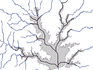 A river is not just a blue line on a map; it has a complex, three-dimensional morphology that is normally defined using cross-sections laid out along the stream centerline. These cross-sections are cut from a terrain model defined by a triangulated irregular network or a grid. Within the stream channel, ecologists define habitat zones such as pool and riffle areas. Around the stream channel is the riparian zone, which describes the transition between terrestrial and aquatic ecology. Within the landscape, the area around the rivers requires much more detailed description than the land distant from rivers.
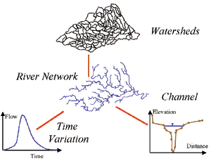 In ArcInfo 8, two new classes of features are supported for network modeling: edges and junctions. The simple versions of these features are like arcs and nodes in ArcInfo 7, but there are also complex edges, which permit interior junctions, and complex junctions, which permit several lines to meet at one location without necessarily all being joined there. Objects are arranged in a hierarchy with the simplest cases at the top and more complicated variants below. The arrows connecting the objects indicate inheritance of properties and behaviors down the hierarchy so that detail is added progressively as it is needed. Customized objects for river and watershed networks are created by adding further layers to this hierarchy.
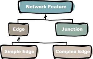 The consortium will hold two meetings per year, one being the GIS Hydro Preconference Seminar at the Esri Annual User Conference in San Diego and the other a GIS in Water Resources Conference, the first of which is planned for February 23-25, 2000, in Austin, Texas. The consortium will produce a book describing the object model for rivers and watersheds and its application in various case studies. At the back of the book, there will be a CD-ROM containing the model template that users can employ to load their river and watershed data into ArcInfo 8. Applications will be built around the object model design in this template. There is no such thing as a single model of rivers and watersheds that will serve all needs. The intent in the consortium effort is to define a base level of functionality that can be further customized and extended to fit particular user applications.