


|
|
||
|
|
|
|
|
|
Kavouras, Inc., to Launch Joint Initiative for Connecting Weather Data Systems with GISDynamic, On-the-fly Weather Information and GIS Merge
For Kavouras customers, this will provide the opportunity for additional GIS analysis and advanced visualization techniques. For GIS users, a wide variety of real-time weather information will be available for the first time in Esri format that can be used to solve a number of complex Business problems.
For instance, precision agriculture professionals will be able to more accurately determine what portions of land received precipitation and determine where best to apply agricultural chemicals. Electric utilities can better define and forecast temperature and other weather variables that affect utility assets and processes such as energy load for a transformer or electrical lines. Broadcast television can display weather information and project the movement of individual storm cells and calculate predicted time of arrival to certain communities with greater accuracy. This provides improved displays and the ability to better calculate and more successfully communicate when and where a serious storm will impact a specific area. Environmental users can take radar-derived rainfall estimates, then calculate how much water fell into a basin. This has implications for stream flow and flood models. Another use is the calculation of the proximity of lightning strikes relative to golf courses, highways, or other man-made features. "Kavouras is helping make it possible to broaden how weather information can be used by thousands of innovators in numerous markets," says Jack Dangermond, president, Esri. "They already helped provide a number of ways to take advantage of this information, and now with the availability of this information in GIS format, the next generation of smart weather information for Esri users is here." "This type of first-to-market offering can redefine an industry," says Ron Sznaider, vice president of R&D at Kavouras. "Bringing weather data to the world of GIS is going to benefit users and drive new applications. This is a new paradigm--merging high-quality, up-to-the-minute weather information with powerful GIS analysis and visualization. It will give users the ability to do things that have never before been available."
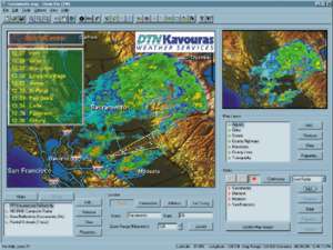
According to company officials, the impetus behind the integration of GIS with Kavouras weather information is that of supplying customers with new, powerful capabilities that have yet to reach the market and would be of tremendous value. "We work closely with our customers to do more than meet their needs; we work to anticipate future needs and to drive innovation," says Sznaider. "This dedication drives developments like this one. We have several initiatives on the board, and we are excited about our initial offering that works with MapObjects." Kavouras has developed a storm tracking system built with MapObjects called StormPro. Now used by broadcast TV stations, StormPro tracks storm systems, storm epicenters, and the areas they affect, and predicts the path of storms over time. By embedding GIS into StormPro using MapObjects, a more detailed analysis of the storm and related information can be performed, giving users a better understanding of storm impact and other storm weather patterns. The company is also working on developing ArcView GIS prototype applications. In addition, Kavouras offers a PC-based MetWork FileServer, fed by a high-speed satellite data delivery system, that will soon contain weather data in Esri format for use in GIS. Internet delivery options will also be available.
As Sznaider described it, today most users of weather information typically work with a stand-alone weather display system as a thin-client application, with limited interactivity and analysis capabilities. With the newly outlined initiative, Kavouras users will have more options as to how they manage this information. "We became an Esri Business partner several years ago and continue to work together now with this new development," says Sznaider. "We are going to gradually increase the amount and variety of weather information that will be available for the entire world. How this information is used is somewhat a function of developers and users of ArcView GIS that will tailor software to their needs. There is a tremendous amount of opportunity here." The company will also provide forecast weather data in GIS format. "The temporal factor will be very significant," adds Sznaider. "The key here is that real-time weather data, updated as often as once per second, will be available for use with new or existing GIS systems," says Toscano. "This is an information breakthrough that we at Esri are very excited about because of what it means to Kavouras users, Esri users, and to the many markets that will benefit."
|
 How important is weather information? Aviation, broadcast television, agriculture, energy Businesses, and transportation are just some of the major markets that rely on timely weather data. Kavouras, Inc., a leading supplier of value-added weather information, provides real-time data via satellite and the Internet as well as analysis and interactive graphic software programs. The company recently embarked on an ambitious campaign to provide its weather information in GIS format and to develop delivery mechanisms such as MapObjects-based applications, ArcView GIS customized applications, and the Internet for providing powerful spatial analysis capabilities.
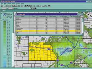 "Real-time weather data has not been readily available to GIS users to date," says Shawn Toscano, Esri. "Kavouras will not only be formatting their weather data for use in Esri software, but may also be creating applications for weather data integration including three-dimensional analysis. By bringing weather information into GIS, analysis tools can be used to solve more complex Business problems."