


|
|
||
|
|
|
|
|
|
Albania Begins Land Reform with GIS
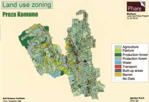
Above right: GIS technology is able to transform the vast amount of diverse geospatial data collected from various past surveys into user-friendly information products. The cornerstone for this reform is the development of a sound land use policy (LUP) plan using ArcInfo and ArcView GIS with its ArcView Spatial Analyst extension to analyze current land use in preparation for land reform measures. An important factor in deciding to use this GIS technology in the development of the LUP project is its ability to transform the vast amount of diverse geospatial data collected from various past surveys of agricultural land, water resources, forest land, and pastures into user-friendly information products needed by decision makers responsible for sustainable land management. The primary objective of the LUP is to introduce sustainable land management that will satisfy the current need for a self-sufficient agricultural program, while protecting rich cropland from land degradation that would affect future production. The current lack of sound land use policy has resulted in widespread land degradation and chaotic development, causing the loss of the best quality farmland to nonagricultural uses. In addition, the land use policy is urgently needed in view of new, large-scale development initiatives such as the planned transportation corridors traversing the whole country, rehabilitation of rural roads assuring year-round access to remote villages, and development of the country's coastal zones. The second priority is to facilitate land consolidation. In Albania, the average area of cropland is only 1.12 hectares per farm, and each farm consists, on average, of four land parcels. This high fragmentation of cropland is unique in Europe and prevents its effective use. Funded by the EU-PHARE program, the GIS-based LUP project has addressed the first task by developing a methodology for sustainable land management. Pilot project activities included the establishment of a GIS laboratory at the Soil Science Institute, the creation of the Inter-Agency Advisory Committee for the LUP project, and the design and implementation of a successful pilot project for sustainable land use management. The interim GIS products derived from the pilot project included a digital elevation model, a slope map, and the delineation of watersheds. Final products included the completion of a flood risk assessment, a soil erosion risk assessment, the delineation of protected forests, the preparation of a land use zoning map, and the creation of a land information system database. This project successfully demonstrated the potential of GIS as a decision support tool for land use managers and environmental planners in Albania, with the country's Minister of Food and Agriculture expressing great enthusiasm for the results of the study and the capabilities of GIS. For more information, contact Renato Cumani, GIS manager, Land Use Policy Project (e-mail: rcumani@hotmail.com). |
 In the midst of political and socioeconomic difficulties, Albanian decision makers are wisely charting a course of action designed to stimulate economic revival and cut the vicious cycle of social unrest and political instability that threatens the country.