


|
|
||
|
|
|
|
|
|
ArcView Spatial Analyst and ArcView Network Analyst Lend a HandGIS Takes Oregon Firefighters a Long Way from the Bucket BrigadeWith horns honking, sirens blaring, and lights flashing, fire engines hustle through streets as motorists and their vehicles scatter out of the way. Appearing out of nowhere and disappearing out of sight, we usually don't give racing fire trucks a second thought. But did you ever wonder where they come from?
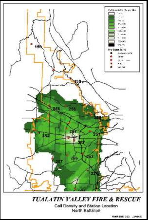
Skip Kirkwood knows all about fire station location planning. Tualatin Valley Fire and Rescue (TVF&R), which serves 10 cities in three counties in northwest Oregon, ended up with several fire stations that were not optimally located--the result of fire district consolidations and rapid growth in the area. At the time (in 1997), Kirkwood, who is manager of Infomatics and Quality Improvement for TVF&R, had just begun to implement Esri's ArcView GIS 3.1 software on his desktop PC using Windows NT. He was about to put it to good use. Developing a New Tool"Siting fire stations is a challenging task that is often oversimplified," says Kirkwood. In the past, many stations were simply located using a two-mile radius scheme. Other methods were flawed because they assumed that fire departments protected only real property, travel speeds were constant at all hours, and emergency events occurred randomly with respect to time. Analytical statistical tools have since proved that nonfire emergencies in TVF&R's service area make up a large percentage of their workload, travel time changes at various times of the day, and emergency events are predictable within certain limits. TVF&R is a consolidated, multijurisdictional fire district that operates 23 stations with 21 career engine companies, two ladder truck companies, and one heavy rescue squad. Seven volunteer companies that provide fire and EMS response as well as rehabilitation and support services augment the response workforce. TVF&R handles approximately 25,000 calls per year. Burgeoning development in that region means constant change in the street network. Consequently, it is critical for Kirkwood to be able to locate fire stations that can handle the changes brought on by these spurts in growth. Variables in speed and distance limited certain types of location testing, such as timing a fire vehicle's travel time over the street network, and this method was not possible in areas where streets were not completed or subject to change. Kirkwood turned to GIS to improve his ability to successfully site fire stations. Two ArcView GIS extensions, ArcView Spatial Analyst and ArcView Network Analyst, make the job a lot easier for him. "I use ArcView Spatial Analyst to do incident density analysis," Kirkwood says. "Of the 25,000 calls per year that we get, I can geocode about 97 percent of them, and then I do a density analysis of where the calls take place. When we're trying to figure out where to build a fire station, we want to put it in the area of highest density for calls," he says. ArcView Network Analyst also plays a part in the site selection process. Kirkwood says that it enables TVF&R to test station locations by generating response polygons using average travel speeds (observed at various times of day) with 95 percent accuracy when compared to actual driven times. In an area that was changing from rural to urban, Kirkwood was able to anticipate the growth by locating a new station that completely covered the previously undercovered rural area. There's More . . .Not only has GIS helped eliminate the guesswork when it comes to locating fire stations, but it's also a valuable resource in other areas of the TVF&R. In addition to deploying traditional 24-hour shift fire companies, the district uses peak activity units (PAUs). These units work nontraditional schedules and move from place to place responding to varying demands for service and district coverage. While the PAU concept was implemented as a cost-saving measure that reduced four million dollars from the budget, it also has enhanced performance. Where and when PAUs should be deployed is a dynamic process and of great interest to the operations staff. GIS helps by providing a means to view incident data readily, quickly query the database, and perform "what if" scenarios. Recently, the team acquired a computer projector, which enabled real-time problem solving and eliminated the wait involved to produce paper maps. Creating Response Performance ZonesThe TVF&R covers a diverse territory that ranges from large industrial facilities to dense urban residential neighborhoods to exclusive farms. With population densities ranging from 25 to 5,000 people per square mile, it is not possible to provide urban levels of coverage throughout the entire district. Using GIS, Kirkwood has developed a benchmark performance standard of coverage that is not based on patterns of development and terrain features, but rather on rational data analysis of geocoded events. Kirkwood hasn't stopped there. He is implementing GIS to assess the impact of potential annexations and urban service areas, and to do event analysis with an eye toward fire and injury prevention. He sees limitless opportunities for GIS at the TVF&R. "Mapping hazardous materials storage sites, residences with disabled people, municipal hydrants, and facility locations can become more efficient with the application of GIS technology," he says. "The next step," Kirkwood adds, "is the implementation of dynamic GIS service in the cab of emergency response apparatus. This will eliminate many of the difficulties associated with too many three-ring binders, outdated map books, transfer of personnel, and rapidly developing communities." For more information, contact Howard A. ("Skip") Kirkwood, Jr., Tualatin Valley Fire and Rescue (tel.: 503-642-0314, e-mail: kirkwoha@tvfr.com). |
 Most likely, the fire stations those trucks call home have been strategically located for optimum response time to emergencies. While feng shui, the ancient Chinese art of placement, might benefit the firemen inside stations with a positive flow of ch'i (energy), you'll be glad to know the science of locating fire stations is geared toward serving those of us in need on the outside.