


|
|
||
|
|
|
|
|
|
Innovative Summer Youth Employment ProgramTeens Become Inner City MappersBy Kate Fields, Executive Director, Greater Eastside Community AssociationThe September 1999 death of 17-year-old Jimmy Barajas may just show up as a State of Michigan statistic on the year's Rate of Teen Deaths by Accident, Homicide, and Suicide report, but for those of us working with at risk kids, his death exemplifies what the terminology really means.
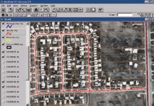
Above right and below left: Knowing the exact locations of the problem would help rid Flint, Michigan, of blight. To that end, a GIS map of data with an exterior physical inventory and building assessment was created.
Given the above conditions, plus significant high school dropout and teen pregnancy rates, the scarcity of job training opportunities, and few recreational activities, it's not surprising that teenage gangs and crime-related activities in Flint are proliferating. Inner City Mappers is a program designed to offer youth a more positive alternative. Pictured at right: CEITA instructor Gary Roth shows mappers a GPS receiver. From left to right: Gemayel Melton, Dwight Laster, David Bowers, Alan Roth. Photo by Dan Bowers.
Through this process we discovered that CEITA had utilized a National Science Foundation grant to create a program called Work/Site Alliance. Their project involved creating a curriculum for high school faculty and students in which they learned how to become proficient in GIS technologies. Luckily for us, CEITA was now in the third year, or replication phase, of this grant, and they were willing to use the Flint community in order to duplicate the program. Other community partners came onboard as we sought to combine resources and build the program. Mott Community College offered the use of their new computer labs, Esri provided ArcView GIS software and licensing rights, program funding came from the Community Foundation of Greater Flint, the Goggins Family Foundation, and Mott College Foundation. Another area nonprofit organization, the Spanish Speaking Information Center, contributed in-kind funds and assistance with youth recruitment. CEITA designed and conducted an intensive two-week Summer Science Camp with the objective of "learning how to utilize GIS in a real-world setting by mapping EPA designated Brownfield sites in the City of Flint, Michigan, using a variety of spatial analysis techniques as well as developing and applying scientific problem-solving skills in the field." GECA provided the overall program development and project management. Twenty youths (ages 14-22 years old) were recruited by flyers distributed in neighborhoods and high schools. It was a diverse group: 14 males and six females, six Hispanic, 10 African-American, and four Caucasian. Two were 14 years old, five were 15, three were 16, two were 17, four were 18, and one each, ages 19-22 years old. Several of the participants were high school dropouts. Amazingly, 14 out of the 20 had never touched a computer before. Pictured at right: Daniel Lopez in Mott Community College computer lab. Photo by Dan Bowers.
There were difficulties to overcome (deficits in basic literacy skills and [non]established work ethics such as punctuality), but the teenagers' pride in their work and sense of accomplishment was self-evident. Three of the dropouts returned to school in the fall including Jimmy Barajas. No one really knows whether the bullet that killed Jimmy was the result of an accident, suicide, or gang-related homicide, but the other "Mappers" and community still mourn the tragic loss of this at risk young man. For more information, please contact Kate Fields, executive director, Greater Eastside Community Association (tel.: 810-233-0507, e-mail: KateFields@aol.com). |
 Jimmy was a participant in an innovative summer youth employment program called Inner City Mappers. Initiated by the Greater Eastside Community Association, this unique, collaborative GIS project had three basic objectives. The first objective was to provide summer employment for inner-city youth; the second was to teach them marketable job skills; and the third was to have them provide a service for their community by mapping Brownfields in Flint and Genesee County, Michigan. The ultimate goal, of course, was to help these young folks envision what a positive, productive life they could have and give them a beginning means of achieving this future for themselves and their own families.
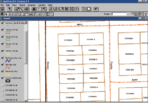 Flint, Michigan, is a classic example of growing inner-city blight and urban distress. Factors such as the loss (since 1978) of close to 50,000 General Motors jobs and the subsequent out-county population migration has left the core city with many problems such as a proliferation of abandoned buildings and the highest child poverty rates in Michigan. A very large percentage of the City's children (and their well-being) are deemed at risk by indicators such as health, educational attainment, family structures, and adequacy of income. According to the Annie E. Casey Foundation (from their annual national report, "Kids Count"), a child is at high risk if they live in a family with four or more of the following characteristics:
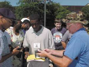 The idea for the program grew out of an earlier connection between the Center for Environmental Information and Technology Applications (CEITA-Eastern Michigan University) and the Greater Eastside Community Association (GECA). As a newly formed community, nonprofit GECA easily identified neighborhood revitalization as a priority. How to go about that goal, however, was a bit more complicated. It was decided that in order to get rid of blight, we needed to know the exact locations and extent of the problem. We decided to create a multilayer GIS map of data (at the parcel level) with an exterior physical inventory and assessment of buildings and property. After designing an assessment tool and conducting the inventory, we then created a database of property conditions and contracted with CEITA to provide the digitized maps and link our data to the maps.
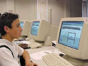 From the first day, we had difficulty getting them to leave the labs at the end of the workday. At the start of the third day they were so proficient on the Internet that we had to stop and explain lab policy of "only educational sites allowed." In addition to the conceptual and scientific learning modules, they gained basic proficiency in Microsoft Office (Word, Access, and PowerPoint) and ArcView GIS software. Lessons were interspersed with field trips designed to show them real-world entities utilizing GIS technologies (Genesee County Treasurer's Office, State of Michigan-MI Information Center, a private company, and land and air surveys). By the third week of the program, they were creating databases of recorded Brownfield sites by downloading information from the Michigan Department of Environmental Quality and the U.S. Environmental Protection Agency. The final, and sixth, week of the program culminated in a public demonstration, complete with handouts and PowerPoint presentations they had created.