ArcUser Online
 |
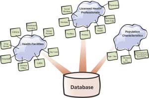
Currently, most community data sharing is situational, not systematic, which limits the data available. Adopting data sharing agreements make a CHSS work effectively. For data sharing to work, databases must be created and maintained in conformance with metadata, data security, and access-and-use standards. ArcIMS, the Esri solution for disseminating GIS and mapping services via the Internet, ensures a very high level of control and security. Not only can departmental databases maintained by government agencies be linked but data from community-based organizations can also be integrated. Using a common platform for dissemination is one way to assure community data sharing. Without a common data dissemination technology, data sharing is difficult, expensive, and problematic. Standardizing on a data dissemination technology can bring together an entire community of data creators and users. The Technology Needed for CHSSCHSS requires appropriate technology. At a minimum, this means high-performance computers, high-speed Internet access, and robust analytical software. CHSS staff should be trained in the use of GIS as well as epidemiological and health risk analysis software. Because a CHSS must be geographically centric, data creation and dissemination tools should conform to federal geographic data standards. The use of GIS software that incorporates these standards ensures that data created can be shared automatically with other cooperating agencies within the larger community. Agencies must also recognize the importance of adopting Internet communication and security standards compatible with existing systems such as the CDC's National Electronic Disease Surveillance System (NEDSS) and Health Alert Network (HAN). CHSS responsibilities are continuous. This means operating surveillance 24/7 with full redundancy and off-site backup. While this level of monitoring is not typical of health departments, it will be required. The days of snapshot analyses and annual report cards are numbered. These methods are no longer sufficiently useful in identifying risks and anticipating hazards to public health. Health and human service agencies must build a secure and integrated GIS that directly links health assets. Private Secured Geography NetworksA geography network, built on geoservers, is capable of analyzing geographic queries and distributing information with geographic relevance. A private secured geography network (PSGN) is simply a collection of geoservers connected in a secured fashion. A single department within a large public health agency can have its own PSGN and directly control information content and access by internal and external entities. The geoserver technology is in conformance with the Health Insurance Portability and Accountability Act (HIPAA) which protects all information concerning a health encounter including the patient's street address and any subsequent geocoding. This health information must be guarded at every turn with automatic capabilities. Public health agencies will be required to put systems in place that will disassociate personal identifiable information from the patient to ensure confidentiality. However, in the event of outbreak or epidemic, this association needs to be quickly restored and made available to responders and caregivers. Organizations participating in a CHSS will create data and distribute it over a secured network. Each organization will operate a geoserver behind its firewall. The data distributed will be completely controlled by each organization. The geoserver, running 24/7, maintains a constantly updated, near real-time copy of the master patient history file. Patient addresses are georeferenced by the point of service address management system and GIS. The CHSS could access geoservers maintained by professional licensing boards for medical, nursing, dental, and other allied health professions that contain the locations and skill sets for medical professionals in the area. Public health agencies, with their own geoservers, could pool data from geoservers of participating organizations and redistribute the results of analyses to agencies when appropriate. Key health and human service resources and consumption information data for the entire area served by the CHSS would be immediately available to every participant. While each participating organization maintains its data securely, perhaps holding different classes of data at a variety of security levels, all data can be automatically integrated when required. Write It DownThe first and most important resource for a health facility considering participation in a CHSS is a written plan. This plan sets forth technological standards along with guidelines for participation in the CHSS. A GIS consultant can prepare a plan that will provide guidance on what, how, and how much such a system will cost. The CHSS plan spells out the data to be generated, who is responsible for its maintenance, the standards to which data will be maintained, and how the data will be accessed and used in emergency and nonemergency situations. Information on assets such as hospitals, clinics, physician offices, blood banks, and laboratories and personnel such as nurses, technicians, and administrators must be kept current. ConclusionGIS is a powerful tool for responding to outbreaks of disease. Its value is well documented in public health literature. In response to the threat of biological weapons, a new health strategy, CHSS, is being developed and GIS is its enabling technology. Using ArcGIS, disparate datasets can be integrated to detect and manage disease outbreaks in ways not previously possible while letting CHSS participants control access to datasets and maintain the confidentiality of health records. For more information, contact |