ArcUser Online
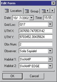
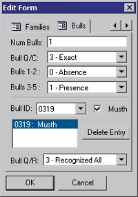
Until 1999, researchers had no GPS capability and used a one-kilometer grid system to estimate the location of observations made in the park. Two years ago, researchers began using GPS units mounted on the dashboards of their jeeps to record sighting locations. Often these GPS readings were nearly as inaccurate as locations derived using the grid system. This was because the animals are often hundreds of meters away from the vehicle, and hence the GPS. The rugged, easy-to-use handheld GPS units have greatly improved the accuracy of location data recorded for each observation. When a field researcher sees an elephant herd, she opens an ArcPad project file on the GPS handheld. It automatically displays a map of the park with her location noted at center. If the researcher is able to drive near the elephants, she collects the GPS location of the sighting, and the unit records the actual elephant location to within 10 meters. If the researcher is not able to get near the elephants, she can look at landmarks on the map display and determine where the elephants are located relative to her position and touch that point on the screen. The unit records the location of the herd's estimated position. Once the GPS handheld records this location, the observer tabs through the edit screens to quickly and easily enter the same information that had been collected manually for 30 years, but now with the added bonus of GPS records. AERP sees another substantial benefit from using mobile GIS. Rather than transferring the data from paper records to the Access database via manual data entry in a process that can take more than an hour, a field staff member merely attaches the handheld to the PC and uploads new observations to the database. This prevents errors that inevitably occur during manual data entry. AERP staff also appreciate the ruggedness of the units. Built for field work in extreme conditions, these devices perform to specification despite the dusty Amboseli environment and the harsh treatment they receive during the off-road observation trips. In addition, the batteries last for an entire day and can be recharged at the Amboseli base camp each night. All agreed that ArcPad running on the Trimble GeoXT is a great solution for the Amboseli research project. Integrating mapping software and GPS in one device has facilitated data collection, and customizing the mapping application specifically to the Amboseli researchers' needs has improved the accuracy of data collection. About the AuthorKevin Corbley is the principal in Corbley Communications Inc., and he may be reached at kcorbley@aol.com. |